This waterfall on the headwaters of Wayah Creek is marked on the topo map, but its very small and overgrown. And there was probably only much water flow due to yesterday's storm.
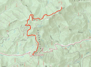
Right past here, we parked at Wayah Gap and started hiking the AT northbound to Wayah Bald. Although the views were somewhat blocked, there was a nice view from the trail looking down towards Franklin under the clouds.
In about 2.5 miles, the trail met up with Bartram Trail for a short ways. A spur led up to Wine Spring Bald. There's a communication tower here, but no views. Continuing on, it was about another mile or so to Wayah Bald and the lookout tower.
There's parking up here, but we enjoyed the hike up. From the top of the lookout tower, we had great panoramic views.
We had lunch up here and enjoyed the clear weather.
Soon, more people showed up, so we started making our way back down the mountain.
Heading back to Franklin, we made a stop at the Wallace Branch Trailhead for Bartram Trail just west of town. It was a just a short ways to a footbridge over a tributary at the base of Ray Cove Falls.
We stopped here for a few minutes to enjoy the falls and get some pictures.
Turning around, we could see Wallace Branch Falls from the trail, but the view was not great. We scrambled down to the upper portion first.
A little further down, we could see more of the falls, but there was nowhere for a good view.
Near Ray Cove Falls, an old overgrown road split from the trail. Taking this, we could make it to the base of the falls, but the view wasn't great here either.


No comments:
Post a Comment