Saturday, October 26, 2019

Boone Fork & Tanawha Trail

Saturday, I left early for a fall foliage hike in the mountains.  It was forecast for light rain, but nothing heavy.  I took US-421 north towards Boone and got on the Blue Ridge Parkway southbound right at 7.  It was still completely dark at this point.  As I drove southbound, the first rays of light were visible.  I stopped at Yadkin Valley Overlook about 10 minutes before sunrise and could see the first rays of light.


The twilight views of the Piedmont were great.


Then I drove a little further to Thunder Hill Overlook to watch the sunrise.


More great views over the foothills and Piedmont.


It was a perfect view from here and the parking area was full, so I was not the only one who woke up early for a beautiful sunrise.  I continued on to Julian Price Memorial Park and parked at the picnic area.  After getting my stuff together, I set out on Boone Fork Trail, going right to hike the loop counterclockwise.  The trail followed Boone Fork downstream and there was some nice fall color showing despite the foggy weather.  A little over a mile, the Mountains to Sea Trail crossed the creek on a new footbridge.


Shortly past here, a steep path led down to the base of Hebron Colony Falls.  It's hard to see much of the waterfall from the base as it flows under and around the rock colony.


So I climbed up the boulders for a nice view of the main drop.


Fall colors along the creek bank framed the falls nicely and the view downstream was beautiful.


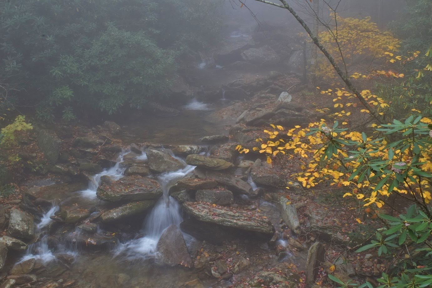
Continuing on the trail, there were some more nice spots along the creek.


I also found another waterfall downstream on Boone Fork Creek, about 15 feet high.  It was a steep scramble down, but a scenic little unnamed waterfall.


The trail followed Boone Fork Creek through one last scenic section.


Then it started following Bee Tree Creek upstream.  There were some rocky sections along the trail.


As it approached the parkway, I turned onto Tanawha Trail and headed west.


Foggy weather prevented sweeping views but the fall color was beautiful, even in the clouds.


I took the short spur to Cold Prong Pond Overlook.


At Cold Prong, I did a short loop around the pond, but it was dried out.


Continuing on, I went as far as Daniel Boone Scout Trail and stopped for a lunch break.  There were some nice cascades on the headwaters of Boone Fork here.


Then I made the long hike back to Price Park.


On the drive home, I made a stop at Grandview Overlook for one last view of fall colors from the parkway.


Tuesday, October 15, 2019

Eagle Rock

Tuesday morning, we broke camp and left Lazy J's.  We headed towards Hendersonville and drove Big Hungry Road into Green River Gamelands.  Our first stop was off Gallimore Road by the Narrows put in.  A gated road led down along a tributary of Hungry River.  There was a scenic little cascade right at the start.


Where the old road curved left, we bushwhacked right and down to the tributary at the base of Case Falls.


It was a pretty nice waterfall for such a small tributary but there was a lot of downfall over it.  Probably a little nicer in high water.  After a couple pictures, we headed back and continued driving down Big Hungry Road to the Long Ridge Trailhead parking area.  We inadvertently started hiking Long Ridge Trail, but realized our mistake and backtracked to the parking area.  We then took the gated road to the right through a couple fields to Bishop Branch Trail.  Turning left here, we soon passed the top of Emily Falls and a short scramble path led to the base.


Emily Falls is only 12 feet high, but very scenic.  Heading back, we made a stop just across the bridge over Hungry River.  A scramble path led down to the river next to some cascades.


But upstream of the bridge was Upper Waterfall on Hungry River.


It's a long cascade just below a dam.  I understand that the dam will be removed some time in the future.  After a couple pictures, we left and headed to towards Lake Lure.


We first stopped at the visitor center at Chimney Rock State Park to get Alex's passport stamped.


Then we drove to the Eagle Rock access.  I had gotten a parking permit so we could visit this new area of the park.  We hiked the Weed Patch Mountain Trail up to Eagle Rock in just a half-mile.  Climbing up the rocks, there were fantastic views all around.


From here, the trail started heading down the mountain.  Just about a mile from the trailhead, the Tunnel Trail split to the right and we followed this short trail towards the base of Eagle Rock.  Right at the end, the trail goes through natural tunnel in the rock.


It was cool to see Eagle Rock from the base.


We continued on Weed Patch Mountain for about another mile and stopped at a creek crossing for a break.


The trail continues for over 8 miles to Buffalo Creek Park in Lake Lure, but we weren't going that far.  After our break, we headed back to the car and started making the drive home.


We stopped in Burlington for dinner at Cancun Mexican Restaurant, one of the few Mexican restaurants with outdoor seating so we could dine with Alex.  The fajitas were great!  It was less than an hour from here to get home.

Monday, October 14, 2019

Salt Gap Waterfalls

Monday morning, we headed to the Salt Gap side of Panthertown Valley.  It was our first visit to this part of the area.  And the weather was looking a lot more favorable today.  After parking, we took the Blackrock Spur.  There was a nice view of Panthertown Valley from here and our first fall color sighting.


We turned in Blackrock Trail and got on Overlook Trail near the summit of Blackrock Mountain.  There were no views from the top, but the trail descended to an open cliff area with stunning views.


This spot may have the best views in Panthertown Valley.


At high elevation, the leaves were really starting to change but not quite peak yet.


Continuing down into the valley, we got on Granny Burrell Falls Trail to the small sliding waterfall.


Beautiful fall colors along Panthertown Creek here.


The waterfall would make a nice slide in warmer weather.


Next, we turned on Great Wall Trail along Big Green Mountain.  The wall was pretty cool but hard to get an unobstructed view.


Where the trail turned left and started to head up, we got off the trail and bushwhacked towards Panthertown Creek Falls.  The woods were open at first, then more overgrown.  As we approached the waterfall, a steep scramble path led to the base.


I climbed up the rocks for a good view and then we had lunch on the rocks.  Heading back, we went left on Granny Burrell Falls Trail to Deep Gap Trail and Frolictown Falls.


I rock hopped across the creek for a straight on view of the falls.


Then we got on Wilderness Falls Trail and began the climb back up.  Shortly, we came to the waterfall and climbed to the base.


A little further on the trail was a path down to the base of the upper drop.


From here, it was just a short ways back to the parking area.


We headed into Cashiers and had dinner at Ugly Dog Taproom.  But before heading back to camp, we had to get one more waterfall.  Driving down NC-107, we parked at the trailhead for Silver Run Falls.  We got a couple pictures of the waterfall, but more people were showing up.


So we climbed up and went to Upper Silver Run Falls.


It's smaller than the main waterfall, but the steep climb up means few people venture this far.


We enjoyed the falls for a bit then headed back down.


Then we headed back to the car and to camp for one more campfire.

Sunday, October 13, 2019

Gorges Waterfalls

Sunday was a rainy morning.  We ate breakfast in the car and then drove to the Frozen Creek access of Gorges State Park.  Our plan was to hit Upper Wintergreen Falls.  We hiked Auger Hole Road about 3 miles to Wintergreen Trail and followed that to the campsite.  After the campsite, the trail was extremely hard to follow, with tons of downed trees over what semblance there was of a path.  Alex was really having trouble and the rain picked up so we decided to head back.  Right past the turn for Wintergreen, Augur Hole Trail was closed due to a landslide.


Turning around, we went back on Augur Hole Trail and got off the road to go down to the waterfalls at the confluence of Auger Fork Creek and Maple Spring Branch.  It was a real steep climb down to the base.  Augur Fork Falls flows down on one side and Maple Spring Branch Falls on the other.


There was a nice view of Augur Fork Falls from the base, but hard to see Maple Spring Branch Falls.  I had to climb up the lower section of the waterfall for a good view.


Such a cool spot with dual waterfalls - there was a great view of Augur Fork Falls looking back.


This area reminds me of a tropical rainforest.  After a lunch break, we climbed back up to Augur Hole Trail and continued back.  In just under a mile, we got off the trail and bushwhacked down to Double Drop Falls.


The bushwhack was pretty steep, but it was short at least.  We got a couple pictures and then finished the hike back.


Before heading back to camp, we went right on Frozen Creek Road for about a mile to see Frozen Creek Shoals.  It's on private property and the view from the road was poor.


On the way back, we stopped again at Headwaters.  The food truck tonight was Tex Mex Barbeque.  I had a pork taco and Sandy had a smoked sausage sandwich.  We got some dry wood from Lazy J and made a fire since it had finally dried out.

Saturday, October 12, 2019

Gorgeous Gorges

Saturday, we left early to take Alex to the mountains for a long weekend of camping and waterfalls.  Our first stop was the visitor center at Gorges State Park to get Alex's passport stamped.


Then we parked at the Rainbow Falls trailhead and began our hike along Horsepasture River.  The trail leaves Gorges State Park and enters Pisgah National Forest in under a mile and begins to follow the river more closely.  Soon we made it to Rainbow Falls.  Even in low water, the waterfall is spectacular.


We climbed down to the base for a good view of this magnificent waterfall.  There was a little rainbow at the base.


Continuing along the trail, next up was Turtleback Falls.


In the summer, it's too crowded with swimmers but today it was looking nice.


From here, we followed the trail to the end of the national forest property.  Drift Falls is on private property but can be seen from the property line.


This was our turnaround point.  Just past Rainbow Falls, I scrambled down to the river for Hidden Falls.


And shortly before we got back to Gorges State Park, we took a side path down to Stairway Falls.


In low water, it didn't look as much like stairs.  After a break, we headed back up to the trailhead.


Heading back on US64, we parked immediately across the bridge over Toxaway Falls.  Carefully crossing the highway, we got behind the guardrail and went east to an old gated road.  The road petered out after a bit but it was pretty easy following the path.  Flagging tape helped us stay on the path down to Toxaway River.  Following the river downstream, we came out at the top of Twin Falls.  A rope assisted with the climb down to the base.


Twin Falls is a really nice waterfall, I was impressed.


And Toxaway River was really scenic going downstream.  After some pictures we made the climb back up.  Before crossing US64, I scrambled down to Toxaway Falls.  I made it to the top of the big drop.


With condos across the gorge, it wasn't a great view.  Getting further down would have been tough, especially for Alex so we headed back to the car.


From here, we drove to Lazy J's and set up camp.  Sandy spotted a food truck at Headwaters outfitters to save us the drive to Brevard.  We had barbeque from the food truck and drinks from the taproom with Alex.  Before returning to camp, we made a short detour on Diamond Creek Road.  Diamond Creek Falls is a roadside waterfall a mile and a half up the road.


It was obscured by rhododendron and wasn't much of a view from the road.  We headed back to camp and built a campfire for a bit before going to bed.