Monday, May 26, 2014

Burnthouse Branch Falls Attempt

Monday morning, we woke up and broke camp. When we had everything packed up, we got on NC-181 and started heading south about 12 miles past the Blue Ridge Parkway. Here, we turned left onto FR 982 and went about a mile and a half, turning left on another forest road (not sure the number of this one) and went about 2 miles upstream alongside Upper Creek. There are several great primitive campsites along this road and not surprisingly, all were occupied on this holiday weekend. We stopped at the end of the road before a big jeep mound and started our hike. We were headed to the Waterfall on Burnthouse Branch, a tributary of Upper Creek. According to Kevin Adams’ book, the waterfall was a little over 2 miles from the trailhead and at the end we’d have to go down steeply to the creek and then rock-hop upstream a bit to see the waterfall. The trail was easy at first, continuing along the gravel road for a little bit over a half-mile. Then it became more of a hiking trail, somewhat overgrown, but easy to follow. After a mile or so, the trail become more narrow and steep as it hugged the ridgeline above Upper Creek. It was still pretty easy to follow though and there was some marking tape along the way. When we had gone about 2 miles, the trail mostly ended and the flagging tape indicated that we needed to go down. This bushwhack down to the base was extremely difficult, steep, and overgrown, but soon we made it down to creek level.


I was a little confused as I thought we were on Upper Creek, not Burnthouse Branch, but we had followed the marking tape, had gone about the right distance, and had to rock-hop upstream a bit to see a not-so-impressive waterfall. Kevin Adams had rated it a 2, so I wasn’t really expecting much.


We relaxed a bit down here, got some photos, and saw some a cute lizard sunning himself on the rocks.


When we were ready, we had to make the tremendously difficult bushwhack back up to the trail. After much trial and error and a few slips, we finally made it back to the trail, which seemed so much easier hiking back. We stopped a few times to go down to the creek and get some shots of some cascades and small falls along Upper Creek and then made it back to the car. We were so tired from the bushwhacking earlier, we decided to finish up and start heading home. Once we got to cell reception area, I checked on a picture of Waterfall on Burnthouse Branch and sure enough, we had gotten the wrong waterfall. All that effort and we didn’t even get it. Well, I guess that means we’ll just have to come back. In Morganton, we had a late lunch/early dinner at Las Salsas, my favorite Mexican restaurant, and then headed home after a great holiday weekend.

Sunday, May 25, 2014

More Wilson Creek Waterfalls

Sunday morning, we were determined to go back and get the waterfalls on Gragg Prong, but today we would be heading in from the other side. We drove to the Blue Ridge Parkway and spotted a turkey in the road. We stopped briefly for a picture then got off the parkway at Roseboro Road to head into the Wilson Creek area. This gravel road eventually becomes FR 981 and leads to a parking area for Lost Cove Trail (#262). There were quite a few cars here as this is another very popular area with many great primitive camping spots.


We hiked along Lost Cove Trail heading downstream along Gragg Prong. In about a half-mile, there was an easy creek crossing and in about a mile, there was a more difficult one that we had to wade. Fortunately, there were big rocks on the other side to sit down and dry off our feet. There was another easy creek crossing just past this one and soon we came out at the top of Upper Waterfall on Gragg Prong.


A large area of exposed bedrock provided a path to walk out next to the waterfall. Although not a large waterfall, the exposed bedrock provided great photo opportunities.


There were a lot of people here, including some camping next to the large pool at the base and quite a few swimming. The waterfall had a few pools in between cascades and a big one at the base.  As one man got out of the water, I inquired about how cold it was. He said it was freezing, but his daughter didn’t seem to think so and she was jumping in and out of the pools.


We headed back up to the trail and went down to view the waterfall from across the pool where some folks had set up camp, although the view wasn’t the best from here as much of the waterfall was hidden behind the bedrock.


After this, we continued on the trail stopping at a couple of smaller cascades between the upper and lower waterfalls.


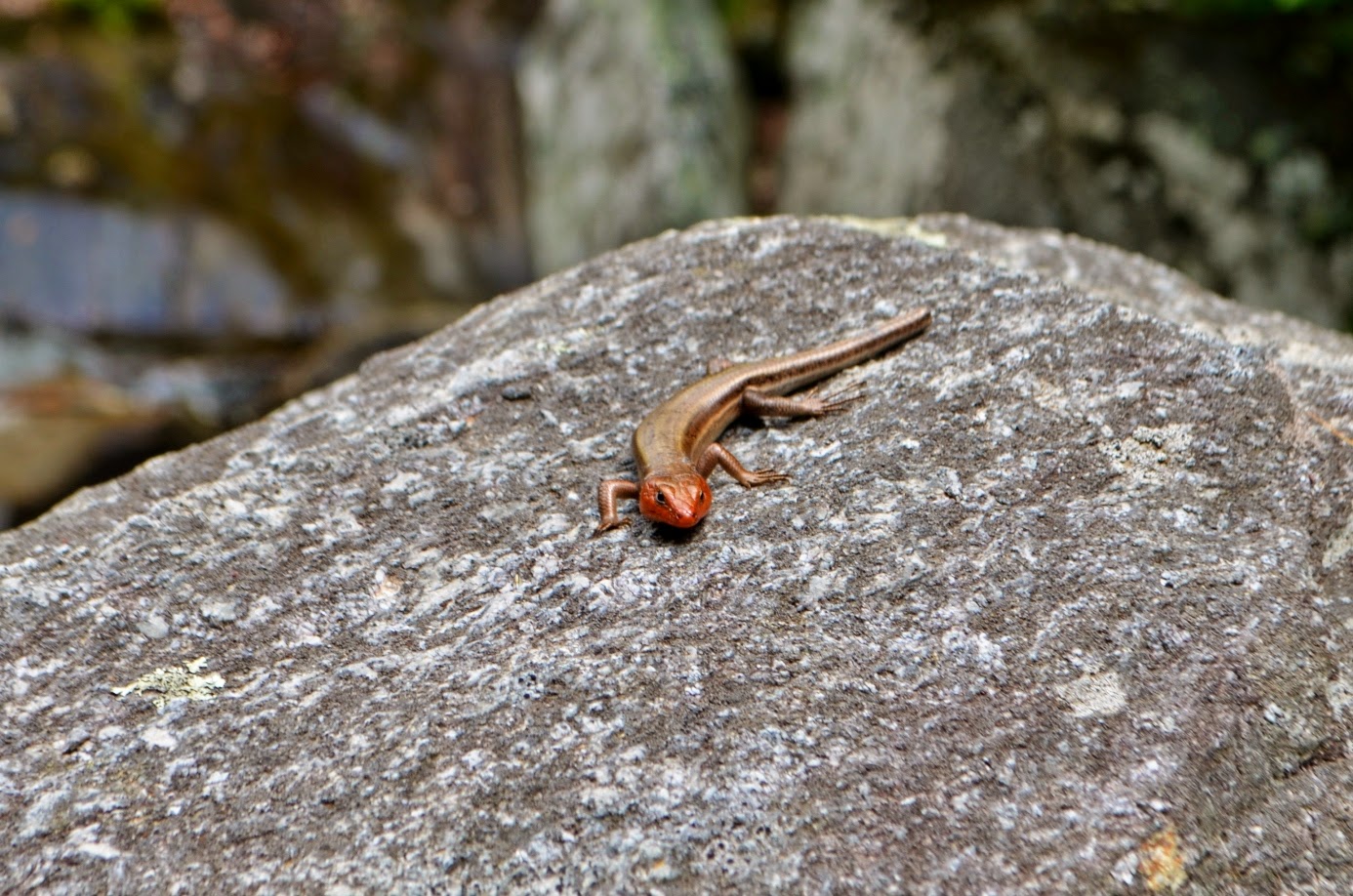
At one spot, there was an area of wet rocks where a large number of Eastern Tiger Swallowtail butterflies had congregated.


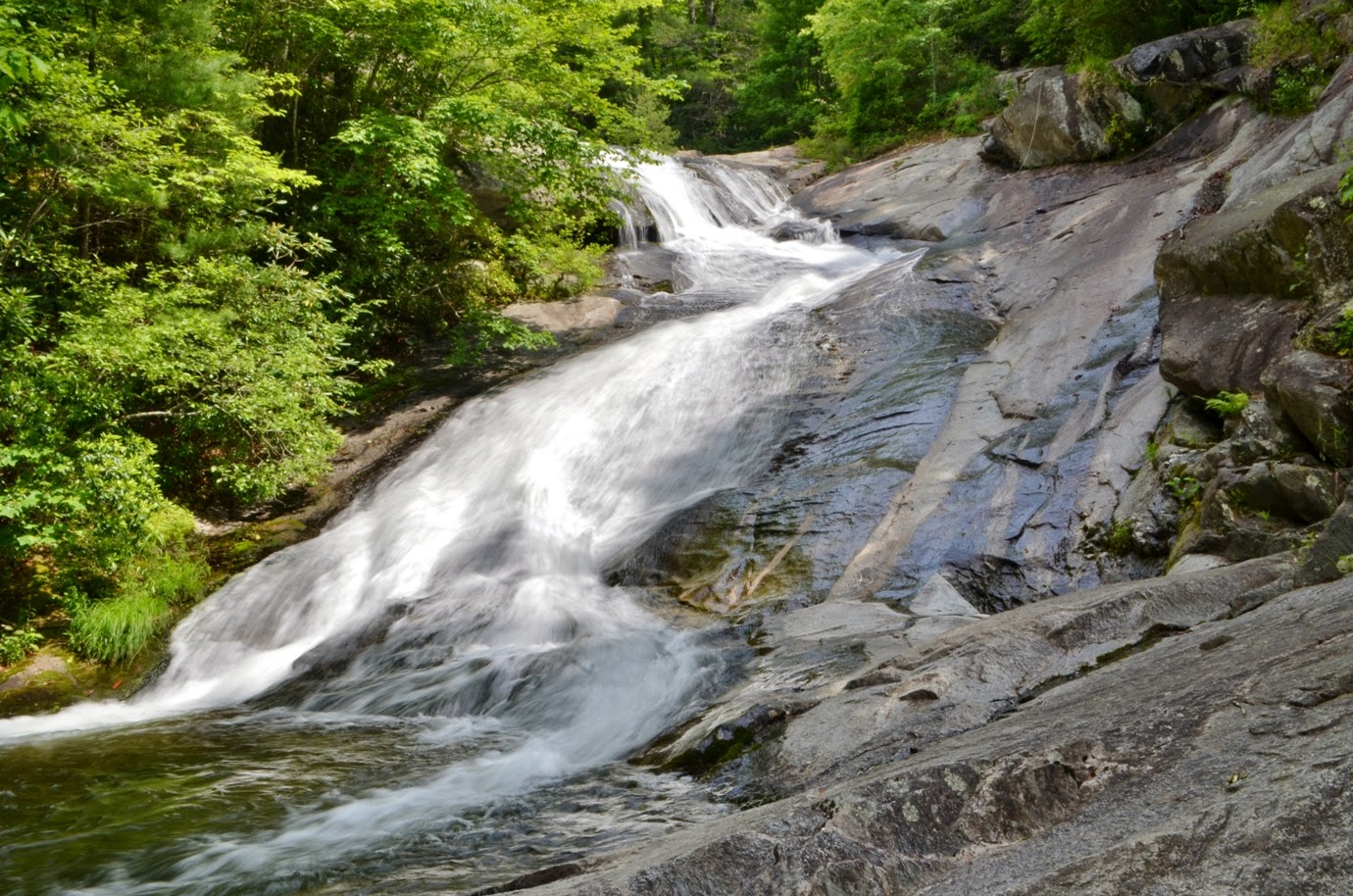
I guess they were drinking from the wet rock or perhaps there was some food there that I couldn’t see. About a quarter-mile from the Upper Waterfall, we came out at the top of the Lower Waterfall.


Usually, you can’t see much from the top of a waterfall, but this one has a gradual enough slope that the view is quite nice as the water slides down the rock into the gorge below. Sandy thought it would be possible to get down to the base from here. I really wouldn’t recommend that anyone try this, although she did make it to the bottom safely by holding onto a rope. Realizing she would never be able to get back up however, I headed back to the trail and continued a short ways and found a very steep and difficult path to bushwhack down to her at the base of the falls.


We got some pictures from here and then bushwhacked back up to the trail and then made our way back to the car. From here, we continued on the forest road to NC-90 in Edgemont and then got on Brown Mountain Beech Road at Mortimer and drove to the trailhead for Harper Creek Trail (#260). The small roadside parking lot was almost completely full with cars parked along the road as well, but we were able to find a spot and started hiking along the trail. It’s quite steep at first as it leads up to a ridgeline and then levels off when it hits the ridgeline. It’s about about a mile and a half to Harper Creek Falls and we passed Yellow Buck Trail and Raider Camp Trail on the way. Towards the end, the trail follows Harper Creek upstream, passing several great backpacking camping spots. As we approached the waterfall, the main trail split to the right and we took a left on a spur trail that leads to the falls. First we went down a steep section to the base, assisted down the final part by a rope.


There were a lot of people here swimming in the water and hanging out on the rocks. Sandy and I ate lunch and then I waded into the pool to get some pictures. Not surprisingly, the water was extremely cold and although the water looked inviting, I didn’t have a swimsuit or a towel, and the water was too cold for me anyways. After that, we climbed back up to the trail and went towards the top. A thick rope allows visitors to rappel down to the middle of the waterfall. As we were getting ready to go down, another couple with a boxer were also getting ready to go down. The woman went down first and the dog wasted no time, hopped onto the steep rock and somehow managed to get down. After that, Sandy and I headed down.


We got some pictures from the middle portion of the waterfall and then headed back up. I do wonder how that dog managed to get back up as its really steep. We hiked back along the trail and then drove out of the forest to NC-181. We drove south for a few miles to the parking area for Upper Creek Falls, our last waterfall for the day. It started raining, heavily for a minute or two, as we were driving here, but by the time we parked, the rain had stopped. We donned our rain jackets just to be safe and then started hiking down the Upper Creek Falls Trail (#268B). The trail is moderately steep as it descends down via switchbacks to the top of Upper Creek Falls, where we could see over the waterfall and looking upstream, could see some cascades above the falls with rhododendron blooming along the creek.


We rock-hopped across the creek and headed down to the base on the trail.


The water level was fairly high and the rocks were wet, so we couldn’t get too far out in the creek, but still managed to get some good photos from the base as well as a couple other points heading back up.


We then rock-hopped back across and returned to the car, making our way back to the campground for the night.

Saturday, May 24, 2014

Wilson Creek Waterfalls

Saturday morning, we headed back to Wilson Creek for more waterfalls. We headed into the area on FR 464 for about four miles to FR 464A and parked at the top of this road. We probably could have driven this road, but decided to just hike down since the RAV4 is not 4WD. The road heads down into the gorge along Little Lost Cove Creek, fording the creek about a half-mile from the start and ends at a primitive campsite. Not surprising on a holiday weekend, there were several tents set up at the campsite. From here, we picked up the hiking trail that runs along the ridgeline above the creek. Along this trail I saw a guy hiking back and asked if he had come from the waterfalls. He indicated that he had and was even nice enough to leave a pile of rocks and some sticks in the shape of an arrow pointing where to get off the trail. The side trail leading down to the falls is not at all obvious, so this was very helpful. He also warned that the trail down is very steep. In about a half-mile from the forest road, we saw the pile of rocks and arrow and started making our way down towards the waterfalls. He wasn’t kidding that this trail was steep. We slowly made our way down, holding on to the many rhododendron along this “trail” to help us get down.


Eventually, we made it to the bottom and climbed out on the rocks to get some pictures of the Upper Waterfall on Little Lost Cove Creek.


From here, we headed up a bit and then followed a very faint trail downstream. Almost immediately we could see the top of the Lower Falls, but we continued following the trail towards the base. The Lower Waterfall on Little Lost Cove Creek was quite impressive, but the late morning sun was shining right on it, making photography difficult.


I tried to get out into the creek below the falls to shoot from a different angle, but the higher water level and slippery rocks made that impossible. So I did the best I could and then we made the steep climb up back to the main trail and backtracked on the trail and forest road to car. Our next stop was Bard Falls. We drove a little further up FR 464 and parked at the trailhead for North Harper Shortcut Trail (266A). Bard Falls is more well-known and popular and as such, there were several cars parked here. We followed the one-mile trail down to North Harper Creek Trail and turned left to follow the creek downstream. Soon, the trail crossed the creek and there was no getting across this one dry. After wading the creek, we followed it downstream about a half-mile to Bard Falls.


We had lunch at the base of the falls while some guys were fishing in the river. After lunch, I climbed out onto the rocks at the base of the falls for some pictures.


There’s an interesting “pothole” in the rock next to the waterfall.


When we finished lunch, we headed back up to the trail, stopping to see some nice cascades along the creek, and then backtracked to the car and made the short drive further up FR 464 to the trailhead for Hunt Fish Falls. There were a lot of cars here as this is one of the most popular hiking, camping, and swimming areas. We followed Hunt Fish Falls Trail (263) for about a mile down to Lost Cove Trail (262) right above the waterfall and got out on the exposed bedrock.


There were a lot of people here swimming, sunbathing, and enjoying the falls.


All of the primitive campsites around here were full as well.


Hunt Fish Falls is two relatively small drops that end in a huge pool. Although not the most impressive waterfall in the area, the ease of access and abundance of recreational activities make it extremely popular.  Above the exposed bedrock, another waterfall tumbled down parallel to Hunt Fish Falls Trail. Although it was very high, the water flow was very light on this one. After we got some pictures from various spots, we continued on Lost Cove Trail heading west for about another mile to a creek crossing. Our plan was to continue on this trail to the waterfalls on Gragg Prong, but it was not meant to be. First, we inadvertently got on Timber Ridge Trail after the creek crossing and hiked a bit before we realized we had gotten on the wrong trail. Then we got back on Lost Cove Trail to where it met up with Gragg Prong and started heading upstream, eventually reaching a creek crossing over Gragg Prong. By this time, we had run out of water and it was getting late. We were both exhausted, so decided to come back tomorrow to get these waterfalls. We made our way back to the cars, stopping for a couple more pictures of Hunt Fish Falls with fewer people around and better light conditions.


Then, the hike back up to the parking area. We decided to get Chinese takeout and have it for dinner back at the campground.

Friday, May 23, 2014

North Harper Creek Falls

We would be staying at Down by the River Campground in Pineola. I generally tend to avoid private campgrounds as they tend to be more crowded, but being a holiday weekend, this was the only one in the area that I could reserve. From Price Park, we headed south on the Blue Ridge Parkway and made a couple of quick stops along the way. First, we stopped at the Wilson Creek Valley Overlook.


The valley is almost 2000 feet in elevation below the overlook and it was interesting to see where we would be spending much of the weekend from this lofty perspective. Then we stopped at the Stack Rock Overlook, where we had nice views of the valley below as well as Grandfather Mountain.


The overlook is close enough to the peak that we could see the mile-high swinging bridge.


Soon, we got off the parkway and checked in and got our tent set up. Then we made the short drive to the Wilson Creek area of Pisgah National Forest, where the majority of our planned waterfalls for the trip were located. We continued south on NC-181 to Pittman Gap Road. At the church, we turned right on FR 464 and went about 2 miles and then turned right on FR 58. The trailhead for North Harper Creek Trail (266) was about a quarter mile down this road. We parked at the trailhead and started hiking down the scenic trail as it followed North Harper Creek downstream.


There were three creek crossings between the trailhead and the waterfall, but we had no trouble getting across by rock hopping. At the top of the waterfall, some rhododendron were blooming and butterflies danced about the blooms.


We crossed the creek at the top of the falls and followed the switchbacks down to the base, where a beautiful backpacking campsite is located.


Sandy is not so keen on getting her feet wet, but I took of my boots and waded around a bit at the base of the beautiful waterfall.


Another smaller, though quite high waterfall was visible just to the right of the falls. After spending some time taking pictures and enjoying the falls, we hiked back up to the car, stopping a few times to see some nice cascades on the creek above the falls.


It was getting late by now and we were both getting hungry, so we headed to Banner Elk and Sandy bought dinner for my birthday at Puerto Nuevo, a very good Mexican restaurant. Then we headed back to camp and built a fire before retiring for the night.

Elk Falls and Blue Ridge Parkway

This year, my birthday was perfectly timed on the Friday before Memorial Day weekend. So I decided to take the day off of work and make the weekend a little longer. Sandy and I left very early in the morning from Raleigh and made our way west to visit some waterfalls in the northwest portion of North Carolina. Our first stop was Elk Falls, also called Elk River Falls or Big Falls, located just north of the small town of Elk Park. We took I-85S/I-40W to Winston-Salem and then US-421N towards Boone. In Boone, we took NC-105S to NC-184N to NC-194S to US-19E to Elk Park. From US-19, we turned Little Elk Road, immediately turned left on Old Mill Road and then an immediate right Elk River Road. This road followed the river about four miles to the parking area in the Appalachian Ranger District of Pisgah National Forest. Although this is a popular area, we arrived early enough that no other people were here. A brief thunderstorm on the way may have helped in keeping the crowds away. From the parking area, we followed the short Big Falls Trail (172) less than half a mile down past the top of the waterfall to the base of the falls.


Elk Falls is a very scenic 65-foot waterfall with a huge pool at the base - a perfect swim hole. It was a little too cold for swimming, in my opinion anyway. I understand that this is also a popular place for cliff jumping. 65 feet is a long drop, even if landing in water and any miscalculations or slips would almost certainly be fatal. The Forest Service strongly discourages such behavior.


Without jumping or anything dangerous, we were able to climb out on the rocks and get some nice pictures and videos of the falls. Elk Falls is certainly a very beautiful waterfall, especially given the ease of access. After a few minutes, we headed back up the trail and stopped at the top for a nice view over the waterfall to the pool below. It certainly looked to me like a mighty long drop from up here. Shortly, we made it back to the car and headed towards our next stop.  We drove east through Newland and Linville and then took US-221 north. Not sure why the GPS directed us to take this route instead of the Blue Ridge Parkway, but it was quite scenic nonetheless. We could see the Blue Ridge Parkway above at several points, including a brief view of the Linn Cove Viaduct from below. We also stopped for a couple of roadside waterfalls along the way.


One, right at the county line between Caldwell and Watauga counties was actually a pretty decent waterfall on Green Mountain Creek, I believe.


We parked right at the county line and walked down to a tunnel under the highway for a good view of this waterfall.


It appeared the waterfall continued below the road, but there was no way to get down for a view. We then got on the Blue Ridge Parkway and stopped at Julian Price Memorial Park for our next real waterfall - Hebron Colony Falls. Although we had visited this waterfall before, I had forgotten my camera so this would be a good opportunity to go back and get some pictures. Previously, the waterfall could be accessed from a short trail off Old Turnpike Road, which was the way we had come in the last time. However, this was a small road with no good spot to park and so parking anywhere on this road is now prohibited (and strictly enforced by state troopers and sheriff’s deputies I understand, although not from experience). So we parked at the picnic area at Price Park and hiked to the falls along Boone Fork Trail. The entire trail makes a five-mile loop, but we were just hiking the first 1.5 miles to the falls and back. Initially, the trail goes through an open meadow where flowers were blooming and numerous butterflies fluttered about.


After this open area, the trail follows Boone Fork downstream, reaching the falls is about another mile. Approaching the falls, there were several nice cascades on the creek.


A short spur trail leads from the trail to the rock colony. The recent rain had made some of the rocks slick, but we slowly made our way our to the boulder field just below the main drop.


Hebron Colony Falls is an interesting waterfall - there’s no huge drop, but rather a countless number of small cascades over, under, and around massive boulders in the creek.


The opportunities for rock scrambling and photography are endless.


We climbed out onto some big boulders at the base of the main drop and had lunch and then spent some time climbing around on various boulders.


Although difficult to see or photograph, the small cascades that form under giant rocks were really cool and probably my favorite part of this waterfall.


After having some fun scrambling around on the rocks, we started hiking back. By the time we made it back to the parking lot, it was getting into the afternoon and we wanted to get checked in to our campsite for the weekend.