Tuesday, we were heading back towards the Dawsonville area, but with only one stop here, though it would be a long one. Our destination was the Wildcat Tract of Dawson Forest. From Steve Tate Highway, we entered the forest at the Wildcat Campground. Originally, we had planned to hike a 12-mile loop, but had a late start, so we decided we would do a shorter 10-mile up and back hike to maximize the number of waterfalls we could get. From the campground, we got on the Wildcat Creek Trail and followed the creek upstream for about a mile. The stream is pretty calm in this section and the trail flat and easy, except for a couple of rock outcrops to climb over and around. There was some fencing to help navigate over the wet rocks. Despite the wilderness feel and the fact that we were likely the only people in this tract of forest, the trails were pretty well maintained and blazed and easy to follow.
After about 1.5 miles, we passed the footbridge over Wildcat Creek and then headed up and then down to the terminus of the Wildcat Creek Trail. Wildcat Creek Trail becomes Fall Creek Trail and almost immediately had to cross Wildcat Creek. There were ropes to aid in fording the creek, but Sandy didn’t want to get her feet wet and found a giant downed tree across the creek and managed to climb across. I followed her; it was rather treacherous and I vowed to return via wading. Right after the crossing, we took a short spur trail that led to the Fourth Waterfall on Fall Creek. For good views of the falls, I had to wade across just below the falls.
Sandy made it across on a log, but after the last one, I just stuck with wading. We got a couple of pictures and then headed back, turning right onto Fall Creek Trail. Almost immediately, the trail starting going uphill steeply and we started to see flurries of snow, though nothing significant and no accumulation. We passed the intersection with Tobacco Pouch Trail and then headed down a bit to a cove and then up again. We could hear the Third Waterfall on Fall Creek, but had to bushwhack from the cove, so we decided to get this one on the way back. Shortly, we came to another creek crossing, but were able to rock-hop this one and after a bit more uphill, we came to the spur trail to Second Waterfall on Fall Creek, the biggest and most spectacular waterfall in the forest.
We spent a bit of time here, taking pictures, relaxing, and eating lunch. The waterfall itself is close to 100 feet and there was a cute little cascade next to it. I used the GoPro to get a wide angle shot with both waterfalls.
When we were finished, we started making our way back. After passing the Third Waterfall on Fall Creek, we got off the trail in the cove and bushwhacked our way back to the falls. There were some logs in the way and I had to wade across the creek to get a good picture.
At one point, I was standing in the frigid water and a flurry of snow came down. I couldn’t help but think that perhaps I was a bit crazy for standing ankle deep in cold water in the snow. Sandy climbed out on to one of the logs, as she was was not fond of getting her feet wet, but I was done climbing logs for the day. When we were finished, we bushwhacked back to the trail and continued on towards Wildcat Creek. Sandy climbed up onto the log again and crossed dry, while I took my shoes off to wade across. Thankfully, it would be the last time I would have to do that for the day. We took Wildcat Creek Trail a little ways back and got on Turner Trail across the footbridge. We followed this for about a quarter-mile and then turned right on Rocky Ford Trail. We only had less than a half-mile to go, but this section was quite steep. It finally leveled off near the intersection with Windy Ridge Trail near the First and Second Waterfalls on Rocky Ford Creek.
We had to bushwhack a little to get down and view these falls.
After a few pictures and video, we started making our way back.
We followed Rocky Ford Trail back to Turner Trail and then followed Wildcat Creek Trail back to the campground to finish our day. By the time we got back to the hotel, it was getting late and we were both very tired. We had leftovers for dinner and got to bed early.
Tuesday, March 25, 2014
Monday, March 24, 2014
Amicalola Falls
Monday morning, after we woke up, we asked the hotel staff for recommendations for breakfast and they suggested Hofer’s. This was just a short walk from the hotel so we gave it a shot and really enjoyed their breakfast. So much so that we ended up eating breakfast here every morning of our trip. After breakfast, we got ready and headed towards Dawsonville for Amicalola Falls State Park, home to Georgia’s largest waterfall. We started by driving all the way up to the top and making the short stroll to the bridge at the top of the waterfall.
The views looking out from this point were great, but we couldn’t see much of the falls. So we started making our way down the West Ridge Staircase. Down many, many steps - more than 400. And going down meant we would have to go back up afterwards. But going down was the easy part and we enjoyed the stroll down alongside the mighty waterfall.
At the base of the stairs, the trail runs across a footbridge over the middle of the falls and then down even more stairs to the lower observation platform for a view of the entire 700-foot waterfall.
We stopped for a while to get some pictures and then slowly made our way back up.
Near the top of the stairs, we talked to an older gentleman who was clearly an experienced hiker in the region. He told us to check out the archway for the Appalachian Trail just behind the visitor center. So after we finished the climb and made it back to the car, we made a quick stop at the visitor center to get a picture of the AT archway.
Then we left the park and headed into Chattahoochee National Forest. We took GA-52E to Nimblewill Church Road and turned left at the church to the gravel Nimblewill Gap Road. After about 4 miles, we pulled into a primitive campsite and hiked upstream along Nimblewill and Bearden Creek. There was no official trail, but we could follow old roads up most of the way. We had several stream crossings along the way, but only one near the beginning at Nimblewill Creek where we had to wade.
About half way up the trail, there was a nice waterslide along Bearden Creek and another small waterfall on a feeder stream, although this was very hard to see through the dense foliage.
As we approached the waterfall, the trail became much more steep and narrow. Although we could see the falls through the trees as we climbed up, there were no views where the trail ended. So I climbed down a precarious wet rock and waded across a small pool to a big rock where I had spectacular views of the waterfall.
Although not well-known, this was a really fantastic waterfall.
After a few pictures I had to make the extremely challenging climb back up to the trail. After that, however, it was really an easy and relaxing hike back downstream to the car. And one more stream crossing at Nimblewill Creek near the end. From here, we went back on Nimblewill Gap Road to Nimblewill Church Road, but soon turned off the paved road onto FS-28-1 for a long drive on windy forest roads. At the fork, we went left on FS-77 (Winding Stair Gap Road) and then turned on FS-77A. We were planning to drive down to Jones Creek for Falls Branch Falls, but the road was partially washed out and we didn’t want to risk getting stuck. However, the drive was not totally in vain as we could stop and see a couple of smaller waterfalls on Upper East Fork of Jones Creek. There was no trail, but they were close to a pulloff on the road.
We bushwhacked down to the third waterfall and then made our way back upstream to view the second and first.
Then we drove back to FS-28-1 and followed that to Hightower Church Road (FS-28). We followed this past a couple of military vehicles and Camp Wahsega and stopped at the US Army Ranger Camp Frank D. Merrill. Although this training ground for the elite Army Rangers is restricted at times, they are nice enough to allow public access to the waterfalls when training is not ongoing. From the pull-off, we hiked down the small hiking trail and soon could hear Lower Falls and found a spot where we could bushwhack down to the base. Surprisingly, there was another couple here, but they were just getting ready to go, so we spent a few minutes taking pictures and enjoying the falls.
When we were done, we climbed back up to the trail and followed it a little further to yet another stream crossing. The water level was high and there was no rock-hopping so we had to wade again. From here, we followed a trail upstream along the river until we got close to the training grounds and crossed on a log. As it turns out, we didn’t really need to cross the stream and could have just backtracked from Lower Falls. Just past the training area was Black Falls.
There is a conveniently placed bridge across the river just in front of the falls that allows for good photos. When we were done, we hiked back up the road to the parking area. It was getting late by this time, so we started heading back to Helen. Along the way, we stopped for Mexican at El Campesino in Cleveland, and then headed back to the hotel.
The views looking out from this point were great, but we couldn’t see much of the falls. So we started making our way down the West Ridge Staircase. Down many, many steps - more than 400. And going down meant we would have to go back up afterwards. But going down was the easy part and we enjoyed the stroll down alongside the mighty waterfall.
At the base of the stairs, the trail runs across a footbridge over the middle of the falls and then down even more stairs to the lower observation platform for a view of the entire 700-foot waterfall.
We stopped for a while to get some pictures and then slowly made our way back up.
Near the top of the stairs, we talked to an older gentleman who was clearly an experienced hiker in the region. He told us to check out the archway for the Appalachian Trail just behind the visitor center. So after we finished the climb and made it back to the car, we made a quick stop at the visitor center to get a picture of the AT archway.
Then we left the park and headed into Chattahoochee National Forest. We took GA-52E to Nimblewill Church Road and turned left at the church to the gravel Nimblewill Gap Road. After about 4 miles, we pulled into a primitive campsite and hiked upstream along Nimblewill and Bearden Creek. There was no official trail, but we could follow old roads up most of the way. We had several stream crossings along the way, but only one near the beginning at Nimblewill Creek where we had to wade.
About half way up the trail, there was a nice waterslide along Bearden Creek and another small waterfall on a feeder stream, although this was very hard to see through the dense foliage.
As we approached the waterfall, the trail became much more steep and narrow. Although we could see the falls through the trees as we climbed up, there were no views where the trail ended. So I climbed down a precarious wet rock and waded across a small pool to a big rock where I had spectacular views of the waterfall.
Although not well-known, this was a really fantastic waterfall.
After a few pictures I had to make the extremely challenging climb back up to the trail. After that, however, it was really an easy and relaxing hike back downstream to the car. And one more stream crossing at Nimblewill Creek near the end. From here, we went back on Nimblewill Gap Road to Nimblewill Church Road, but soon turned off the paved road onto FS-28-1 for a long drive on windy forest roads. At the fork, we went left on FS-77 (Winding Stair Gap Road) and then turned on FS-77A. We were planning to drive down to Jones Creek for Falls Branch Falls, but the road was partially washed out and we didn’t want to risk getting stuck. However, the drive was not totally in vain as we could stop and see a couple of smaller waterfalls on Upper East Fork of Jones Creek. There was no trail, but they were close to a pulloff on the road.
We bushwhacked down to the third waterfall and then made our way back upstream to view the second and first.
Then we drove back to FS-28-1 and followed that to Hightower Church Road (FS-28). We followed this past a couple of military vehicles and Camp Wahsega and stopped at the US Army Ranger Camp Frank D. Merrill. Although this training ground for the elite Army Rangers is restricted at times, they are nice enough to allow public access to the waterfalls when training is not ongoing. From the pull-off, we hiked down the small hiking trail and soon could hear Lower Falls and found a spot where we could bushwhack down to the base. Surprisingly, there was another couple here, but they were just getting ready to go, so we spent a few minutes taking pictures and enjoying the falls.
When we were done, we climbed back up to the trail and followed it a little further to yet another stream crossing. The water level was high and there was no rock-hopping so we had to wade again. From here, we followed a trail upstream along the river until we got close to the training grounds and crossed on a log. As it turns out, we didn’t really need to cross the stream and could have just backtracked from Lower Falls. Just past the training area was Black Falls.
There is a conveniently placed bridge across the river just in front of the falls that allows for good photos. When we were done, we hiked back up the road to the parking area. It was getting late by this time, so we started heading back to Helen. Along the way, we stopped for Mexican at El Campesino in Cleveland, and then headed back to the hotel.
Sunday, March 23, 2014
Lake Rabun Waterfalls
It was getting around lunch time, so we stopped for fast food in Walhalla. When we finished lunch, we got on US-76 and followed that into Georgia as we crossed the Chattooga River. In Clayton, we followed US-441 south to Lake Rabun and got on Lake Rabun Road to our first waterfall in Georgia - Angel Falls in the Lake Rabun Beach Recreation Area in Chattahoochee National Forest. This camping and recreation area was closed, so we parked at the Angel Falls Trailhead, just up the road from campground 2. The trail lead through a wooded area to the back of the campground and then headed up following Joe Creek. Right at the campground, we could see the First Waterfall on Joe Creek from a footbridge.
This one is a small, 15-foot stairstep waterfall, and was our first Georgia waterfall of the trip. From here, we followed the Angel Falls Trail upstream. Near the start of the trail, we saw a figure of a person made of stones surrounding a tree stump.
In about a half-mile, we reached Panther Falls, a larger tiered waterfall along Joe Creek.
From this point, the trail became much steeper, heading up past Panther Falls via switchbacks to another waterfall, Middle Falls on Joe Creek, above Panther Falls.
Finally, after a little over a mile, we got to the top of the trail, where a wooden platform provided opportunities to view Angel Falls. Despite it still being winter and there being little foliage, Angel Falls was difficult to view.
A thick canopy of rhododendron almost completely blocked our view and a downed tree further blocked the falls. We could tell it would be a nice waterfall if only we could actually see it.
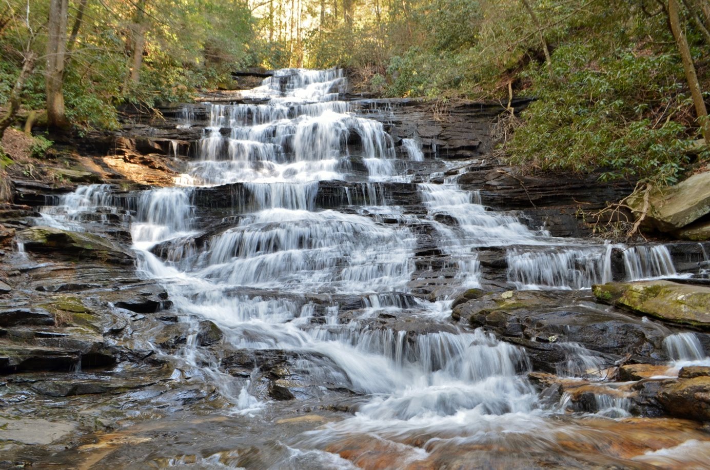
We tried from different vantage points, but really couldn’t get much of a view, so we headed back to the car. Our next waterfall was only a short ways away. We continued on Lake Rabun Road to the Lake Seed Dam and crossed to get on Bear Gap Road. After about 1.5 miles, we pulled over to park at the trailhead for Minnehaha Falls. The trail to the falls is short, less than a half-mile, but steep. But the rewards were well worth it. This waterfall was very scenic and there was no foliage blocking our views.
We spent about 10 minutes here, enjoying the falls and taking pictures, having the falls to ourselves.
As we were getting ready to go, another couple arrived, with the man giving the young lady a piggyback ride. The trail was muddy and I guess she didn’t want to get her shoes dirty. So, we left and let them have the falls to themselves. Back at the car, we made our way to Helen and checked in to our hotel - Riverbend Motel & Cabins. After getting checked in, we strolled around the cute Alpine village and had dinner at Cowboys & Angels. After dinner, we were tired and went to bed early.
This one is a small, 15-foot stairstep waterfall, and was our first Georgia waterfall of the trip. From here, we followed the Angel Falls Trail upstream. Near the start of the trail, we saw a figure of a person made of stones surrounding a tree stump.
In about a half-mile, we reached Panther Falls, a larger tiered waterfall along Joe Creek.
From this point, the trail became much steeper, heading up past Panther Falls via switchbacks to another waterfall, Middle Falls on Joe Creek, above Panther Falls.
Finally, after a little over a mile, we got to the top of the trail, where a wooden platform provided opportunities to view Angel Falls. Despite it still being winter and there being little foliage, Angel Falls was difficult to view.
A thick canopy of rhododendron almost completely blocked our view and a downed tree further blocked the falls. We could tell it would be a nice waterfall if only we could actually see it.
We tried from different vantage points, but really couldn’t get much of a view, so we headed back to the car. Our next waterfall was only a short ways away. We continued on Lake Rabun Road to the Lake Seed Dam and crossed to get on Bear Gap Road. After about 1.5 miles, we pulled over to park at the trailhead for Minnehaha Falls. The trail to the falls is short, less than a half-mile, but steep. But the rewards were well worth it. This waterfall was very scenic and there was no foliage blocking our views.
We spent about 10 minutes here, enjoying the falls and taking pictures, having the falls to ourselves.
As we were getting ready to go, another couple arrived, with the man giving the young lady a piggyback ride. The trail was muddy and I guess she didn’t want to get her shoes dirty. So, we left and let them have the falls to themselves. Back at the car, we made our way to Helen and checked in to our hotel - Riverbend Motel & Cabins. After getting checked in, we strolled around the cute Alpine village and had dinner at Cowboys & Angels. After dinner, we were tired and went to bed early.
Saturday, March 22, 2014
Jones Gap Waterfalls
After lunch, we continued on into South Carolina to Jones Gap State Park. It was a busy day and the parking lots were full. Luckily, we had a reserved campsite, so we were able to head to the camper parking lot. After checking in, we set up our tent at Site 1 along the Hospital Rock Trail. Once we were set up, we went for an evening hike up to Rainbow Falls. I had been to this waterfall before, but Sandy had not, and since it was one of my favorites in South Carolina, I wanted her to see it. The first half-mile or so along Jones Gap Trail is pretty easy as it meanders along the Middle Saluda River. When Rainbow Falls trails splits off, however, it gets a bit more strenuous.
At first, its not too bad as the trail gradually heads up following Cox Camp Creek upstream, but then departs from the creek and gets quite steep. After a lot of stairs and switchbacks, the trail levels off before reaching Rainbow Falls, a spectacular 100-foot plunge over a cliff face.
The last time I was here, the water levels were higher and I couldn’t get near the falls due to the wind and spray. This time, it was a little calmer and I was able to climb up on the rocks a bit to get some more pictures. We spent a few minutes here enjoying the waterfall, before heading back down.
We stopped by the car to grab dinner and then headed back to the campsite, built a fire, and ate dinner. It was a very early start to our day, so it wasn’t long after sunset that we fell fast asleep. Sunday morning, we woke up at daybreak and quickly broke camp. There was a threat of rain; I don’t mind hiking in the rain, but breaking camp in the rain is no fun. We got the car all packed up and then headed back out on the Jones Gap Trail.
This time, we headed about a mile down the trail to see Jones Gap Falls. This is a nice 50-foot waterfall, although the water flow is not particularly good.
We visited during a wet March; I would imagine that in the drier times, there’s not much of a waterfall to see. When we were done here, we hiked back to the parking area and and left. Our next waterfall was also in Jones Gap State Park, but we had to drive a short ways to get to the trailhead. We left the park and turned left on Duckworth Road and then right on Falls Creek Road and parked at the kiosk at the trailhead. By this time, it started drizzling a bit, but not heavy rain. We donned our rain gear and started out, hiking up the steep trail following an old road. After climbing up for a while, the trail leveled off a bit and we crossed Little Falls Creek. But soon, the trail got steep again as we approached the waterfall. When we got to the falls, we were both really impressed with this spectacular waterfall. It’s much less well-known and popular than Rainbow Falls, but just as beautiful. Unfortunately, the rain had picked up a bit and that interfered a bit with taking pictures and video, but I did the best I could.
First I climbed down to the lower section; there were rocks across the pool at the base that allowed connecting to the Hospital Rock Trail on the other side, but it was too slippery in the rain to attempt a crossing. Then I headed up to see the upper section.
Either section by itself would have been an impressive waterfall, but together they made a truly spectacular sight. We might have spent a bit more time here, but given the rain, we decided to head back down. Back at the car, we drove back to the main road and then turned right on US-276/SC-11, the Cherokee Foothills Scenic Highway, and headed west towards Georgia. But before leaving the Mountain Bridge Wilderness Area, we stopped quickly at Wildcat Wayside for one more waterfall - Wildcat Branch Falls. This one is right on the side of the road and made for an easy stop.
We got a couple pictures of the waterfall and hiked back a short ways on the trail to see an old chimney.
Then we continued along the scenic highway towards Georgia.
At first, its not too bad as the trail gradually heads up following Cox Camp Creek upstream, but then departs from the creek and gets quite steep. After a lot of stairs and switchbacks, the trail levels off before reaching Rainbow Falls, a spectacular 100-foot plunge over a cliff face.
The last time I was here, the water levels were higher and I couldn’t get near the falls due to the wind and spray. This time, it was a little calmer and I was able to climb up on the rocks a bit to get some more pictures. We spent a few minutes here enjoying the waterfall, before heading back down.
We stopped by the car to grab dinner and then headed back to the campsite, built a fire, and ate dinner. It was a very early start to our day, so it wasn’t long after sunset that we fell fast asleep. Sunday morning, we woke up at daybreak and quickly broke camp. There was a threat of rain; I don’t mind hiking in the rain, but breaking camp in the rain is no fun. We got the car all packed up and then headed back out on the Jones Gap Trail.
This time, we headed about a mile down the trail to see Jones Gap Falls. This is a nice 50-foot waterfall, although the water flow is not particularly good.
We visited during a wet March; I would imagine that in the drier times, there’s not much of a waterfall to see. When we were done here, we hiked back to the parking area and and left. Our next waterfall was also in Jones Gap State Park, but we had to drive a short ways to get to the trailhead. We left the park and turned left on Duckworth Road and then right on Falls Creek Road and parked at the kiosk at the trailhead. By this time, it started drizzling a bit, but not heavy rain. We donned our rain gear and started out, hiking up the steep trail following an old road. After climbing up for a while, the trail leveled off a bit and we crossed Little Falls Creek. But soon, the trail got steep again as we approached the waterfall. When we got to the falls, we were both really impressed with this spectacular waterfall. It’s much less well-known and popular than Rainbow Falls, but just as beautiful. Unfortunately, the rain had picked up a bit and that interfered a bit with taking pictures and video, but I did the best I could.
First I climbed down to the lower section; there were rocks across the pool at the base that allowed connecting to the Hospital Rock Trail on the other side, but it was too slippery in the rain to attempt a crossing. Then I headed up to see the upper section.
Either section by itself would have been an impressive waterfall, but together they made a truly spectacular sight. We might have spent a bit more time here, but given the rain, we decided to head back down. Back at the car, we drove back to the main road and then turned right on US-276/SC-11, the Cherokee Foothills Scenic Highway, and headed west towards Georgia. But before leaving the Mountain Bridge Wilderness Area, we stopped quickly at Wildcat Wayside for one more waterfall - Wildcat Branch Falls. This one is right on the side of the road and made for an easy stop.
We got a couple pictures of the waterfall and hiked back a short ways on the trail to see an old chimney.
Then we continued along the scenic highway towards Georgia.
Green River Waterfalls
For the last week of March, Sandy and I headed to the mountains of North Georgia for a “spring break” trip to hunt waterfalls in a new state. We had gotten Waterfall Hikes of North Georgia by Jim Parham as a guide and our goal was a total of 50 waterfalls! Saturday morning, we left early to get a start on our waterfall hunting. We were camping the night at Jones Gap State Park in South Carolina and stopped in Saluda, NC on the way to get a start on our waterfalls. From I-26/US-74 west of Charlotte, we took exit 59 and turned right on Holbert Cove Road. From the exit, it was about 3.2 miles to a pull-off on the side of the road, just before the road crosses Cove Creek. When we arrived, there was only one other car at the pull-off. We would hit two waterfalls from here, both in the Green River Game Land. Our first waterfall was Bradley Falls. From the parking area, we followed the blue-blazed trail through an open field and then into the woods. Shortly, we had our first stream crossing, with Creekside Falls flowing down the side of the cliff face into Cove Creek.
Not really a waterfall, but rather pretty nonetheless. Something to distract us from the cold water. The water level at the creek was high enough that there was no way to cross dry. So we took our boots and socks off and waded across the creek. This would be the first of many times getting our feet wet on this trip. Once across the creek, we put our shoes and socks back on and continued along the trail. At first, the trail was pretty easy to follow with blue blazes on the trees to mark the way. As we got closer to the falls, however, the blazes disappeared and the trail became a bit harder to follow. I followed one side trail down to the top of the falls, but there was no good view here, so I headed back up. There were several splits in the trail, so it was a bit tricky to follow. After a couple of wrong turns, we followed the correct trail past several downed trees to a rock outcrop on the cliff overlooking the waterfall. From here, we had a decent view across the gorge to the waterfall, but trees were partially obscuring the view.
The waterfall has two plunges on the left and right sides. From the cliff overlook, the smaller left stream is visible, but the larger right is partially blocked by trees. It is possible to get down to the base for better views, but that requires rappelling down a steep cliff. We saw a couple of people in full climbing gear making the trip down, but considering that we’re not experienced climbers and didn’t have gear, we had to be content with views from the cliff overlook. There was another spot along the cliff back just a bit where we could see the right side better, but it was still partially blocked by trees.
After a few pictures, we started heading back. Some more people were heading to the area as we were leaving, including several at the creek crossing. They were desperately trying to find a way across without getting wet, but were having no luck. We waded across and headed back to the car. The start of our hike to the next waterfall was conveniently right across the road. The trail to Little Bradley Falls starts on the opposite site of the road, just across the bridge over Cove Creek. This trail is blazed red and runs about a mile to the falls.
About half-way through, there was another stream crossing. There was an extended family here, with the men about half-way across the creek, rearranging the rocks to try and provide an easy crossing for the women and children in the group. The crossing they made, however, looked a little treacherous. We saw a couple coming back who crossed at some downed trees; this looked like a much easier route, so we went the way they had come. Shortly after the stream crossing, we passed the ruins of some old structure with a couple of mostly-collapsed chimneys and then soon made it to the waterfall. Little Bradley Falls is a very scenic 35-foot tiered waterfall.
We had beat the family here, so had the falls to ourselves for a few minutes to get some pictures and videos. Soon, more and more people were arriving, so we started making our way back. By the time we got back to our car, there were at least a dozen cars parked along both sides of the road - clearly this was a popular destination in the area and we were glad that we arrived early. From here, we headed toward Saluda and took US-176 east for about 3 miles to Pearsons Falls Road. Pearson’s Falls was our next waterfall for the day. Although located on private property owned by the Tryon Garden Club, the falls are open to the public for a fee of $5 per person. We paid at the gate and then made the short stroll up the trail to the waterfall.
It was a beautiful walk along Colt Creek to this spectacular waterfall.
We got a few pictures and videos and then made our way back, stopping a few times to view the first signs of spring wildflowers along trail on the way back.
By the time we were done, it was getting into the afternoon and we were getting hungry. There was a Subway near I-26 and we stopped here to get lunch. We both got foot-long subs, eating half and saving the other half for dinner at camp. In hindsight, we should have gotten lunch first and had a picnic at Pearson’s Falls.
Not really a waterfall, but rather pretty nonetheless. Something to distract us from the cold water. The water level at the creek was high enough that there was no way to cross dry. So we took our boots and socks off and waded across the creek. This would be the first of many times getting our feet wet on this trip. Once across the creek, we put our shoes and socks back on and continued along the trail. At first, the trail was pretty easy to follow with blue blazes on the trees to mark the way. As we got closer to the falls, however, the blazes disappeared and the trail became a bit harder to follow. I followed one side trail down to the top of the falls, but there was no good view here, so I headed back up. There were several splits in the trail, so it was a bit tricky to follow. After a couple of wrong turns, we followed the correct trail past several downed trees to a rock outcrop on the cliff overlooking the waterfall. From here, we had a decent view across the gorge to the waterfall, but trees were partially obscuring the view.
The waterfall has two plunges on the left and right sides. From the cliff overlook, the smaller left stream is visible, but the larger right is partially blocked by trees. It is possible to get down to the base for better views, but that requires rappelling down a steep cliff. We saw a couple of people in full climbing gear making the trip down, but considering that we’re not experienced climbers and didn’t have gear, we had to be content with views from the cliff overlook. There was another spot along the cliff back just a bit where we could see the right side better, but it was still partially blocked by trees.
After a few pictures, we started heading back. Some more people were heading to the area as we were leaving, including several at the creek crossing. They were desperately trying to find a way across without getting wet, but were having no luck. We waded across and headed back to the car. The start of our hike to the next waterfall was conveniently right across the road. The trail to Little Bradley Falls starts on the opposite site of the road, just across the bridge over Cove Creek. This trail is blazed red and runs about a mile to the falls.
About half-way through, there was another stream crossing. There was an extended family here, with the men about half-way across the creek, rearranging the rocks to try and provide an easy crossing for the women and children in the group. The crossing they made, however, looked a little treacherous. We saw a couple coming back who crossed at some downed trees; this looked like a much easier route, so we went the way they had come. Shortly after the stream crossing, we passed the ruins of some old structure with a couple of mostly-collapsed chimneys and then soon made it to the waterfall. Little Bradley Falls is a very scenic 35-foot tiered waterfall.
We had beat the family here, so had the falls to ourselves for a few minutes to get some pictures and videos. Soon, more and more people were arriving, so we started making our way back. By the time we got back to our car, there were at least a dozen cars parked along both sides of the road - clearly this was a popular destination in the area and we were glad that we arrived early. From here, we headed toward Saluda and took US-176 east for about 3 miles to Pearsons Falls Road. Pearson’s Falls was our next waterfall for the day. Although located on private property owned by the Tryon Garden Club, the falls are open to the public for a fee of $5 per person. We paid at the gate and then made the short stroll up the trail to the waterfall.
It was a beautiful walk along Colt Creek to this spectacular waterfall.
We got a few pictures and videos and then made our way back, stopping a few times to view the first signs of spring wildflowers along trail on the way back.
By the time we were done, it was getting into the afternoon and we were getting hungry. There was a Subway near I-26 and we stopped here to get lunch. We both got foot-long subs, eating half and saving the other half for dinner at camp. In hindsight, we should have gotten lunch first and had a picnic at Pearson’s Falls.
Subscribe to:
Posts (Atom)