The last week of October, Sandy and I headed to the US southwest for a week in Zion. We flew out Saturday morning from RDU on Frontier Airlines. It was our first time flying them, but everything went smoothly and the flight attendants were very friendly. Even after paying for bags and seat upgrades, it was a lot cheaper than other airlines and we got direct flights. Our flights even arrived a bit early to Las Vegas at about 930. After getting our luggage, we headed to the rental car center. Avis upgraded our reservation and we got a convertible Mustang for the week. From Las Vegas, we got on I15 north for about 30 minutes and got off for Valley of Fire Road. The road heads through some remote desert terrain before entering Valley of Fire State Park after about 15 miles. After paying the admission fee, we continued east and turned left on White Domes Road at the visitor center. We drove almost to the end, parking at the third parking area after Fire Canyon Road at the trailhead for Fire Wave Trail. After getting our stuff together, we crossed the street to pick up the trail. Right at the start, the desert views here were just great with gorgeous red rock mountains all around.

It was a totally different environment than what we're used to hiking in. No trees and sparse plant life, though there were many cacti, creosote bushes and other desert flora.

The sandy trail descended down towards the base of Gibraltar Rock then south and east around the mountain. Gibraltar Rock stood out like a monolith and was visible along the entire hike.

After passing around the mountain, the trail then headed southeast across open desert and the rocks began to show the red and white stripes of Fire Wave.

Soon we made it to the Fire Wave, a beautiful area of candy-striped white and red rock that resembled a fiery wave.

It was just amazing that the rocks could naturally be so colorful.

Sandy found a small cave where we could relax in for a few minutes to avoid the desert sun - no trees means no shade. After a break, we started heading back.

Back at the car, we drove the rest of the way to the end of White Domes Road and the trailhead for White Domes Loop. From the trailhead, we hiked south to do the loop in the clockwise direction. The trail initially descended down a gorge between the colorful mountains.

The rocks and mountains here were so colorful and the Aztec sandstone had eroded into some amazing formations.

Soon we came to the site where the ruins of a rock wall were visible - part of the set from the 1966 movie The Professionals.

Valley of Fire is a very popular filming location. The trail then turned west and led through a dry slot canyon on Kaolin Wash, known as the Narrows.

True to its name, it was very narrow. The trail then turned north passing by more interesting rock formations.

We started to hike through more open desert with White Domes to our right. The rocks became more eroded as we continued.

Soon, we began to spot some rock windows that we could see completely through.

One of these windows was quite large - eventually this will erode into an arch.

Finally, the trail started to loop back around, passing a small cave in the mountain.

Past here the trail came back out at the road and we made our way back to the car.

From here, we drove back down White Domes Road, making a quick stop at the visitor center. While Sandy used the facilities and bought some drinks, I hiked out to the Balancing Rock for some pictures.

The trail is only about a tenth of a mile. I walked around a bit to view the Balancing Rock from different angles.

From the far side, it doesn't appear to be balancing, but the rock had a bunch of holes eroded in it. Hiking back, I could see the half-moon over Valley of Fire.

It was a beautiful scene. We met back up at the visitor center and continued heading east. We made a quick stop at Seven Sisters, seven large rock monoliths.

I couldn't find a good spot to view all of them and there were many people here picnicking. The picnic shelters here distracted from the scene and it didn't seem appropriate to have them. Continuing east, we made one last stop just before the east entrance to the park. As we got on the Elephant Rock Trail, I spotted a rock that resembled a dragon.

The light was in just the right angle to illuminate the "mouth" and look like it was breathing fire. Just past here, we went left to hike the loop in the clockwise direction. We passed Elephant Rock shortly but the view from the trail wasn't great.

I did find a cool view spot between two rocks.

From there, the trail ran right next to the road for a while before looping back through the desert. The sun was getting lower in the sky and the moon was clearly visible.

The rocks around here were really eroded with many holes and small caves.

This part of the loop trail was also the Old Arrowhead Road Trail and was quite scenic.

After completing the loop, I went back to Elephant Rock and managed to find a better view.
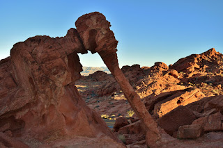
It was just amazing how much this rock arch resembled an elephant. It was getting late, close to sunset so we found a nice spot to watch the sun dip below the mountains.

But the park closes at official sunset, so we headed back to the car and left the park.

Driving into Overton, we checked into the North Shore Inn and had dinner across the street at La Fonda. It was a long day, so went to bed shortly after dinner.

It was a totally different environment than what we're used to hiking in. No trees and sparse plant life, though there were many cacti, creosote bushes and other desert flora.

The sandy trail descended down towards the base of Gibraltar Rock then south and east around the mountain. Gibraltar Rock stood out like a monolith and was visible along the entire hike.

After passing around the mountain, the trail then headed southeast across open desert and the rocks began to show the red and white stripes of Fire Wave.

Soon we made it to the Fire Wave, a beautiful area of candy-striped white and red rock that resembled a fiery wave.

It was just amazing that the rocks could naturally be so colorful.

Sandy found a small cave where we could relax in for a few minutes to avoid the desert sun - no trees means no shade. After a break, we started heading back.

Back at the car, we drove the rest of the way to the end of White Domes Road and the trailhead for White Domes Loop. From the trailhead, we hiked south to do the loop in the clockwise direction. The trail initially descended down a gorge between the colorful mountains.

The rocks and mountains here were so colorful and the Aztec sandstone had eroded into some amazing formations.

Soon we came to the site where the ruins of a rock wall were visible - part of the set from the 1966 movie The Professionals.

Valley of Fire is a very popular filming location. The trail then turned west and led through a dry slot canyon on Kaolin Wash, known as the Narrows.

True to its name, it was very narrow. The trail then turned north passing by more interesting rock formations.

We started to hike through more open desert with White Domes to our right. The rocks became more eroded as we continued.

Soon, we began to spot some rock windows that we could see completely through.

One of these windows was quite large - eventually this will erode into an arch.

Finally, the trail started to loop back around, passing a small cave in the mountain.

Past here the trail came back out at the road and we made our way back to the car.

From here, we drove back down White Domes Road, making a quick stop at the visitor center. While Sandy used the facilities and bought some drinks, I hiked out to the Balancing Rock for some pictures.

The trail is only about a tenth of a mile. I walked around a bit to view the Balancing Rock from different angles.

From the far side, it doesn't appear to be balancing, but the rock had a bunch of holes eroded in it. Hiking back, I could see the half-moon over Valley of Fire.

It was a beautiful scene. We met back up at the visitor center and continued heading east. We made a quick stop at Seven Sisters, seven large rock monoliths.

I couldn't find a good spot to view all of them and there were many people here picnicking. The picnic shelters here distracted from the scene and it didn't seem appropriate to have them. Continuing east, we made one last stop just before the east entrance to the park. As we got on the Elephant Rock Trail, I spotted a rock that resembled a dragon.

The light was in just the right angle to illuminate the "mouth" and look like it was breathing fire. Just past here, we went left to hike the loop in the clockwise direction. We passed Elephant Rock shortly but the view from the trail wasn't great.

I did find a cool view spot between two rocks.

From there, the trail ran right next to the road for a while before looping back through the desert. The sun was getting lower in the sky and the moon was clearly visible.

The rocks around here were really eroded with many holes and small caves.

This part of the loop trail was also the Old Arrowhead Road Trail and was quite scenic.

After completing the loop, I went back to Elephant Rock and managed to find a better view.

It was just amazing how much this rock arch resembled an elephant. It was getting late, close to sunset so we found a nice spot to watch the sun dip below the mountains.

But the park closes at official sunset, so we headed back to the car and left the park.

Driving into Overton, we checked into the North Shore Inn and had dinner across the street at La Fonda. It was a long day, so went to bed shortly after dinner.