This past weekend was our annual Big Brevard trip. Having taken a lot of time off of work, I couldn’t take any more, so I left after work Friday evening. I met up with Bill and we drove out, arriving at Kuykendall campground a little bit before 9. There was still just enough daylight left to get our tents set up before dark and then we spent a little while socializing around the campfire before going to sleep. In the morning, we woke up and got started early for a day of waterfall hunting. Right at 8, we took a group shot of the entire group before breaking up into smaller groups for the day’s activities. Right after the picture, it started raining and it turned out my tent was leaking. I threw all my stuff in my car and covered it with a tarp, hoping for the best. Then we took off, heading west on US-64 to NC-215 north. It was about 20 miles to our first destination - Lower Waterfall on Sam Branch and Waterfall in Wash Hollow. We parked along the side of NC-215 in a sharp left-hand curve, about four miles north of the Blue Ridge Parkway. We followed a steep path up a bank then the trail leveled off, following what looked like an overgrown old logging road. It was only ten minutes or so to the Lower Waterfall on Sam Branch, a scenic cascading waterfall.
There are a lot more waterfalls on Sam Branch going upstream, but its extremely challenging, so we only planned to hit this easily accessible one. After a few minutes here, we crossed the creek and could already see the next waterfall - Waterfall in Wash Hollow. This was another long, sliding waterfall.
The sun actually poked out from behind the clouds, about the only time we'd see the sun today, and made photography a bit more difficult. We spent a few minutes here, then started heading back. Before we got to the first waterfall, we bushwhacked down a bit and came out below some more cascades below the waterfall.
From here, we could see the Lower Waterfall on Sam Branch more completely and a big log near the base made for some good pictures.
Once we were finished here, we made the short hike back to the car and then a very short drive up NC-215 to a pulloff just past the bridge over West Fork Pigeon River.
Here, we could see the roadside Waterfall on West Fork Pigeon River as it flowed under the road.
We climbed out onto the rocks on the south side of the bridge for some pictures and to enjoy the falls and then went to the other side of the bridge and scrambled down a steep hill to the base of the waterfall.
Here, we could see the waterfall flowing under the High Arch Bridge on NC-215. Normally, I would think a road would be a distraction and take away from the view of a waterfall. But this lovely stone bridge, built by the Civilian Conservation Corps in the 1930s, really added something to the scenery. When we were finished, we climbed back up to the road and started driving back south on NC-215. We had initially planned to hit up the waterfalls on Bubbling Spring Branch, but decided to skip these at it had started to rain and we had several other waterfalls to hit today. Instead, we continued past the Blue Ridge Parkway and turned onto Forest Road 4663. In about 2 miles, there is a turn for 4663-B and we parked here, not sure of the condition of this second road. The Forest Service recommends 4WD, though hiking the road, it seemed doable for a 2WD vehicle. It was about 0.6 miles to the end of the forest road, where three paths split off.
First, we took the one to the right that lead steeply up a hill and then leveled off. Along here, we saw some Indian Pipe alongside the trail.
This interesting plant is all white - no green - and is not photosynthetic, but rather parasitic, deriving energy from a forest fungus. Shortly after the trail leveled off, a side path marked by flagging tape led down to the base of Upper Dill Falls, a very scenic 25-foot waterfall.
In total, it may be even higher, but it was difficult to see the upper portions. And the recent rain made climbing too far up on the rocks dangerous.
After a few minutes, we headed back to the end of the forest road and then took the middle path that led down to Dill Falls.
Dill Falls is a really beautiful waterfall, probably my favorite of the weekend. In total, it’s about a 50-foot drop on Tanasee Creek with a short freefall followed by a long slide.
The area around the falls is pretty clear so there were great photo opportunities. We took turns climbing out on the rocks and downed trees in the creek in front of the falls getting pictures of this beautiful waterfall.
Then we started making our way back to the car. As we were driving back along FS-4663, Grace’s car in front of us slid off the side of the road. We all stopped and could see that it wouldn’t be easy to get the car back on the road. So Betsy and Leslie drove to the end of the forest road where there was a house. Fortunately, the nice gentleman and his wife came back with a truck and chains and saved the day, pulling Grace’s car safely back onto the road. He certainly knew what he was doing; this was not the first time he had to rescue some tourists. We thanked him and gave him some money and gasoline for helping us, then continued on our way. We drove a little further down NC-215 and parked along the road at Living Waters Ministry. It had started raining heavily at this point, so we waited in the cars for a little while, hoping the rain would clear. After ten minutes or so, it was looking as though the rain has not intention of quitting. So, despite the rain, we hiked down to Bird Rock Fall. Although the weather made for miserable hiking, it also made for much more powerful waterfalls.
As we approached Bird Rock Falls, there were two narrow waterfalls flowing down the side of the huge cliff above the falls. I don’t think these normally exist, except after a good rain.
I've visited this waterfall before and never seen the water pouring down the cliff face. And Bird Rock Falls itself was flowing much more powerfully than when I had seen it in the past.
The water, however, was very brown and muddy; I guess the heavy rains had stirred up mud and sediment upstream. From here, we hiked back up to the trail to see Mill Shoals - two waterfalls in one.
French Broad Falls on North Fork French Broad River and Shoal Creek Falls on its namesake creek come together to form two 15-foot waterfalls in a semi-circle. It’s tricky to get a picture of both without a very wide-angle lens and especially in the heavy rain.
Here the water was again very brown and muddy. A couple of people in bathing suits came down to the falls and were planning to swim, but decided against it due to the mud. We headed back to the cars and several people were tired of the rain and wanted to go back to camp. So I hopped in the car with Justine, Grace, Isabel, and Monica and we continued on for more waterfalls. We got on Shoal Creek Road, which turns into Forest Road 475 entering Pisgah National Forest and followed this to the Pisgah Center for Wildlife Education. Behind the center, we got on the orange-blazed Cat Gap Trail (#120) and followed this for less than a mile to a short spur leading to Waterfall on Cedar Rock Creek.
Although only about 20 feet high, this was a very scenic waterfall with the main flow coming down to the left and a smaller flow on the right. I’m not sure if this would have two distinct flows in drier times.
There were also some beautiful rhododendron blooming near the falls, adding some color to the scenery. We then hiked back to the car and drove a short ways back on Forest Road 475 to the gated FR-5095. It was about a mile down this closed forest road to our last waterfall of the day - Waterfall on Long Branch. Despite walking on a gravel road, the heavy and consistent rain all day made this a bit more like walking through a swamp. But we were already soaked, so what difference did a little more water make. Where the road crossed Long Branch, we followed a steep side trail up to the base of the waterfall.
This waterfall is a 15-foot freefall, followed by a wide slide fanning out over down a large rock face. The water flow was so high that the upper drop looked like the water was exploding out of the cliff face.
Unfortunately, the high water also prevented us from getting out into the middle of the base where we could have gotten better pictures. A lot of tree branches and foliage were in the way, partially obscuring the views of the falls. Nonetheless, it was quite a waterfall. When we were done, we hiked back to the car and then made our way into Brevard for dinner at El Ranchero. Nothing like some good Mexican food and beer after a long day of hiking and exploring. We made it back to camp a little bit before dark and socialized around the campfire before getting to bed.
Saturday, June 28, 2014
Friday, June 13, 2014
A Visit to Waterford
We woke up Friday morning, groggy from being woken up so early. And to make matters worse, the elevators were down. We talked to the guy at the front desk and he got our luggage on a cart and brought it down in the service elevator. He even offered us some coffee and breakfast even though it wasn’t open yet. We took a cab to the train station and took and train back to Dublin and then another to Waterford. Paul and Eleanor picked us up at the train station and we went back to their house for a visit. The house was a beautiful cottage along the hillside with a great view of Waterford across the river. And the gardens were fabulous; they even had a pond with a small waterfall. We had a great dinner of steak, chicken, potatoes, sausage, and salad. It was the best we had eaten all week! After dinner we socialized and walked around a bit through the gardens. A path led down through thick flowers and vegetation and led to a gate to the road leading up to their house. Unfortunately, the last train to Dublin left at 630, so we had to catch that one and then a cab to our last hotel - Dublin Airport Manor. After checking in, we had some pizza and took a shower before bed. It was going to be a long day. I went for a short walk in the morning around a neighborhood across the street to stretch my legs. Then we headed to the airport and had a pretty uneventful flight back. There was no line at all to clear US Customs in Toronto and soon we were back in Raleigh.
Thursday, June 12, 2014
Connemara
Thursday morning, Sandy still wasn’t feeling great, so she stayed and rested at the hotel, while the rest of us went on the Connemara and Cong Tour with Galway Tour Company again. We were picked up at our hotel, and after picking up other guests, our tour guide Ken dropped off those who were doing Cliffs of Moher at the coach station and the rest of us stayed on the bus. We headed north on N84 and made our first stop at Ross Errilly Friary near the County Galway/County Mayo line. This 14th century friary was a lot of fun to explore.
Although the roof was gone, there were lots of narrow doorways to duck through to navigate between rooms.
The friary included an old church and bell tower, living quarters for the monks, and an open cloister. There were also a number of grave sites, both standing up and along the floor.
After about 15 minutes or so, we headed back to the bus and continued on towards Cong. Just outside the village, we made a quick detour to see Glebe Stone Circle, just from the bus, as there was no good place to park.
Then we headed into the village of Cong and had some time to explore around this town that was the setting for the movie The Quiet Man.
Ken told us that this movie from the 1950s played a big part in opening Ireland up to tourism.
In Cong, I walked around a little bit in Cong Woods just outside the village, stopping to see the Monk’s Fishing House.
The Cong-Clonbur Trail leads from here to Clonbur Woods, essentially providing a hiking trail between Loughs Corrib and Mask.
But I didn't have enough time for thorough exploring so just got some pictures near the trailhead. However, the forest was very beautiful here with big old trees and an open patch full of wildflowers.
After a few minutes in the woods, I headed back to the town to see some other points of interest, including the beautiful runs of Cong Abbey and the Quiet Man Statue, commemorating the movie that had put Cong on the map.
When we were finished in Cong, we continued west into the mountainous Connemara area. The bus got on R300 and crossed Lough Mask. Along the way, Ken told us some Irish history and the poor conditions that the Irish lived in under British landlords. Much of the hunger and famine was due to the British shipping food back to Britain for sale so that there wasn't enough left in Ireland. We saw the ruins of a tiny little house that may have been home for a family of ten or more. Then, we made a quick photo stop at Lough Nafooey, a beautiful glacial lake on the border between County Mayo and County Galway. After this stop, we got off the main road and continued heading west on L1601 along the lough. On the west side of the lake, we got on L1301 and made another short photo stop in the Connemara mountains. Looking east, we had nice views of Lough Nafooey from here. After a short stop, we continued heading west, getting on N59 and making another short stop at Killary Harbour. Although often called Killary Fjord, it is actually a fjard as the the cliffs are shorter and less steep than a fjord. In the dark waters here of the harbor, we could see many mussel farms. There was also a fairy tree here. According to legend, fairies live under and around these trees and misfortune will befall those who disturb it, while good luck will come to those who hang a bit of fabric. The tree was just about covered in ribbons and other small pieces of fabric. From here, we drove just a short ways further to Kylemore Abbey and Victorian Walled Garden.
Admission to the abbey and grounds was not included in the tour, but we did get a discounted group rate of €8 by buying them from Ken. This was our longest stop and we got a full 2 hours here, but there was a lot to see. Ken recommended taking the shuttle from the entrance to the gardens to save time, but I decided to walk and ended up beating the shuttle anyway. It was a pleasant hike along the Woodland Walk with ancient trees and blooming rhododendron along the way. The Victorian Walled Gardens were absolutely beautiful and so perfectly manicured.
I walked around for a bit getting shots of the beautiful grounds and flowers.
On the hills overlooking the garden, the rhododendron were in full bloom, which complimented the grounds nicely. Once I had walked around the whole garden, I stopped at the tea room to get lunch. There was a line and I didn't want to waste a lot of time, so I passed, and took the shuttle back to the entrance area (which probably took longer than walking it). Back at the entrance, I headed over to the Abbey. Kylemore Castle was originally built in the 19th century as a private residence for Mitchell Henry, a wealthy doctor from London. In 1920, the castle was purchased by the Benedictine Nuns and has been an abbey since. Although not particularly old by Irish standards, this was one of the most beautiful buildings we had seen on our trip.
It is truly a fairy tale castle. And not only was the castle gorgeous, it was in a most beautiful setting, with the calm waters of Pollacappul Lough in front of the abbey and rhododendron covered mountains behind it.
Only a few rooms are open to the public for touring as the nuns still live here, but it was beautifully decorated and a delight to walk through.
Although the abbey had been damaged by fire, much of the interior had been restored to its original glory. Once done in the abbey, I continued on towards the Gothic Church, walking along beautiful Pollacappul Lough. More rhododendron were blooming along the lake's calm waters. The Gothic Church was a small cathedral built by Mitchell Henry in memory of his wife Margaret.
Mrs. Henry had dies of dysentery and her husband wanted a suitable memorial built at her beloved Kylemore. Although small, it was beautiful inside and out.
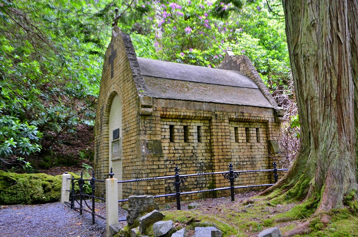
There were two more quick spots I wanted to check out on the way back just past the church. The first was the mausoleum where Mr. and Mrs. Henry are buried.
Despite the extravagance of the castle and church, the mausoleum was not show showy. Right past here was the ironing stone, a large iron-shaped rock.
According to legend, it was thrown by the giants Cú Chulainn and Fionn Machuail on the surrounding mountains. Those who can successfully stand with their backs to the stone and throw a pebble over the top will be granted a wish! There were five pillars sticking out of the ground near the stone that kind of looked like giant's fingers sticking up out of the ground. I got a couple pictures, but was starting to run out of time. I swung by the cafe and grabbed a sandwich and drink to have on the bus ride back. We turned off the main road onto R344 to make our way back to Galway. We had to stop once for some sheep that had gotten into the road and then made our last stop of the tour at Inagh Valley near Lough Inagh. It was a beautiful little spot, nestled among the Twelve Bens Mountains whose summits were covered in clouds. There was even a scenic little cascade right along the road. From here, it was a little bit over an hour back to Galway and the last part between Salthill and downtown Galway took the longest as the traffic was bad. Ken dropped us off at the coach station and we headed to the King’s Head Pub to have a drink on our last night in Galway. The 800 year old pub gets its name from a former resident - Peter Stubbers, an English colonel under Cromwell who is suspected to be the executioner who beheaded King Charles I. After a beer, I headed back to the hotel to check on Sandy. She had rested all day, but was a little hungry, so we walked down to Salthill and got Chinese. She had a wonton soup, which was good for her stomach, and I had spicy chicken. Then we headed back to the hotel and got our stuff packed up. Before going to bed, I headed out to the beach to get some pictures of the almost-full moon over Galway Bay. There was a rather rowdy Irish wedding reception at the hotel, but I can usually sleep through loud drunk people. But not through a fire alarm. Apparently, some idiot smoked a cigarette in his room and set off the fire alarm at 2 in the morning. Not a pleasant way to wake.
Although the roof was gone, there were lots of narrow doorways to duck through to navigate between rooms.
The friary included an old church and bell tower, living quarters for the monks, and an open cloister. There were also a number of grave sites, both standing up and along the floor.
After about 15 minutes or so, we headed back to the bus and continued on towards Cong. Just outside the village, we made a quick detour to see Glebe Stone Circle, just from the bus, as there was no good place to park.
Then we headed into the village of Cong and had some time to explore around this town that was the setting for the movie The Quiet Man.
Ken told us that this movie from the 1950s played a big part in opening Ireland up to tourism.
In Cong, I walked around a little bit in Cong Woods just outside the village, stopping to see the Monk’s Fishing House.
The Cong-Clonbur Trail leads from here to Clonbur Woods, essentially providing a hiking trail between Loughs Corrib and Mask.
But I didn't have enough time for thorough exploring so just got some pictures near the trailhead. However, the forest was very beautiful here with big old trees and an open patch full of wildflowers.
After a few minutes in the woods, I headed back to the town to see some other points of interest, including the beautiful runs of Cong Abbey and the Quiet Man Statue, commemorating the movie that had put Cong on the map.
When we were finished in Cong, we continued west into the mountainous Connemara area. The bus got on R300 and crossed Lough Mask. Along the way, Ken told us some Irish history and the poor conditions that the Irish lived in under British landlords. Much of the hunger and famine was due to the British shipping food back to Britain for sale so that there wasn't enough left in Ireland. We saw the ruins of a tiny little house that may have been home for a family of ten or more. Then, we made a quick photo stop at Lough Nafooey, a beautiful glacial lake on the border between County Mayo and County Galway. After this stop, we got off the main road and continued heading west on L1601 along the lough. On the west side of the lake, we got on L1301 and made another short photo stop in the Connemara mountains. Looking east, we had nice views of Lough Nafooey from here. After a short stop, we continued heading west, getting on N59 and making another short stop at Killary Harbour. Although often called Killary Fjord, it is actually a fjard as the the cliffs are shorter and less steep than a fjord. In the dark waters here of the harbor, we could see many mussel farms. There was also a fairy tree here. According to legend, fairies live under and around these trees and misfortune will befall those who disturb it, while good luck will come to those who hang a bit of fabric. The tree was just about covered in ribbons and other small pieces of fabric. From here, we drove just a short ways further to Kylemore Abbey and Victorian Walled Garden.
Admission to the abbey and grounds was not included in the tour, but we did get a discounted group rate of €8 by buying them from Ken. This was our longest stop and we got a full 2 hours here, but there was a lot to see. Ken recommended taking the shuttle from the entrance to the gardens to save time, but I decided to walk and ended up beating the shuttle anyway. It was a pleasant hike along the Woodland Walk with ancient trees and blooming rhododendron along the way. The Victorian Walled Gardens were absolutely beautiful and so perfectly manicured.
I walked around for a bit getting shots of the beautiful grounds and flowers.
On the hills overlooking the garden, the rhododendron were in full bloom, which complimented the grounds nicely. Once I had walked around the whole garden, I stopped at the tea room to get lunch. There was a line and I didn't want to waste a lot of time, so I passed, and took the shuttle back to the entrance area (which probably took longer than walking it). Back at the entrance, I headed over to the Abbey. Kylemore Castle was originally built in the 19th century as a private residence for Mitchell Henry, a wealthy doctor from London. In 1920, the castle was purchased by the Benedictine Nuns and has been an abbey since. Although not particularly old by Irish standards, this was one of the most beautiful buildings we had seen on our trip.
It is truly a fairy tale castle. And not only was the castle gorgeous, it was in a most beautiful setting, with the calm waters of Pollacappul Lough in front of the abbey and rhododendron covered mountains behind it.
Only a few rooms are open to the public for touring as the nuns still live here, but it was beautifully decorated and a delight to walk through.
Although the abbey had been damaged by fire, much of the interior had been restored to its original glory. Once done in the abbey, I continued on towards the Gothic Church, walking along beautiful Pollacappul Lough. More rhododendron were blooming along the lake's calm waters. The Gothic Church was a small cathedral built by Mitchell Henry in memory of his wife Margaret.
Mrs. Henry had dies of dysentery and her husband wanted a suitable memorial built at her beloved Kylemore. Although small, it was beautiful inside and out.
There were two more quick spots I wanted to check out on the way back just past the church. The first was the mausoleum where Mr. and Mrs. Henry are buried.
Despite the extravagance of the castle and church, the mausoleum was not show showy. Right past here was the ironing stone, a large iron-shaped rock.
According to legend, it was thrown by the giants Cú Chulainn and Fionn Machuail on the surrounding mountains. Those who can successfully stand with their backs to the stone and throw a pebble over the top will be granted a wish! There were five pillars sticking out of the ground near the stone that kind of looked like giant's fingers sticking up out of the ground. I got a couple pictures, but was starting to run out of time. I swung by the cafe and grabbed a sandwich and drink to have on the bus ride back. We turned off the main road onto R344 to make our way back to Galway. We had to stop once for some sheep that had gotten into the road and then made our last stop of the tour at Inagh Valley near Lough Inagh. It was a beautiful little spot, nestled among the Twelve Bens Mountains whose summits were covered in clouds. There was even a scenic little cascade right along the road. From here, it was a little bit over an hour back to Galway and the last part between Salthill and downtown Galway took the longest as the traffic was bad. Ken dropped us off at the coach station and we headed to the King’s Head Pub to have a drink on our last night in Galway. The 800 year old pub gets its name from a former resident - Peter Stubbers, an English colonel under Cromwell who is suspected to be the executioner who beheaded King Charles I. After a beer, I headed back to the hotel to check on Sandy. She had rested all day, but was a little hungry, so we walked down to Salthill and got Chinese. She had a wonton soup, which was good for her stomach, and I had spicy chicken. Then we headed back to the hotel and got our stuff packed up. Before going to bed, I headed out to the beach to get some pictures of the almost-full moon over Galway Bay. There was a rather rowdy Irish wedding reception at the hotel, but I can usually sleep through loud drunk people. But not through a fire alarm. Apparently, some idiot smoked a cigarette in his room and set off the fire alarm at 2 in the morning. Not a pleasant way to wake.
Wednesday, June 11, 2014
The Burren
Wednesday, we were doing a tour with Galway Tour Company to the Burren and Cliffs of Moher. I had contacted the tour operator before we left and they picked us up at our hotel, rather than having to get back to downtown Galway first thing in the morning. We switched buses at the coach station and headed south around the bay to begin our tour. As we were leaving County Galway, we made a quick photo stop at Dunguaire Castle and then crossed into County Clare. Our first stop to get out of the bus was at Corcomroe Abbey.
For about 15 minutes, we walked around the 13th century monastery ruins, viewing the ancient graves and structures.
There was a tomb effigy of Conor na Siudane Ua Briain, an early king of Ireland, that looked like something out of a movie.
The doorways between rooms in the monastery were very small and I had to duck to fit through, but had fun scrambling around in the ancient ruins. Outside the abbey itself were a number of old gravestones, some ancient and some more recent, but it made a very beautiful setting. Leaving the abbey, our next stop was in the village of Ballyvaughan, right on Galway Bay. It was primarily a bathroom and coffee stop, but I walked around a bit on the docks and got some pictures of the bay. There was a sign showing a car falling off the end of the dock; I guess some people thought it was a bridge? Well, I had no intention of driving off the dock, but did enjoy the views of beautiful Galway Bay. Looking out across the bay, our hotel in Salthill was somewhere on the other side, but too far away to discern. Leaving Ballyvaughan, we got off main roads and onto a very bumpy road heading into the Burren.
We made a short stop at the Ballyalban Ring Fort and took the opportunity to walk the ancient site.
There wasn't much of a fort left but we could see the raised circular path around the enclosed area.
Back at the bus, we headed a little further into the Burren and stopped at Poulnabrone Dolmen, a 6000-year old neolithic structure, consisting of two portal stones supporting a horizontal capstone across the top.
From the right angle, it kind of resembled the Greek letter pi or Stonehenge.
I walked all around to get pictures of it from various angles as well as the surrounding landscape.
This was a great area to see the karst landscape of the Burren. Limestone pavement stretched out all around with vegetation growing in the clints between the grikes.
After twenty minutes or so here, we headed back for the bus and started driving further into the Burren. We passed a couple interesting ruins shortly after leaving, including Carran Medieval Church and Leamaneh Castle. Unfortunately, Sandy got really sick at this point and we had to leave the tour prematurely. Back in Galway, she took a cab back to the hotel to rest and I walked back for the chance to see more of the city. I passed Galway Cathedral and Eyre Park before leaving the city towards Salthill.
The Salthill Promenade was a particularly nice walk right along Galway Bay and the weather was lovely.
Along the way, I stopped at a grocery store and got some bottled water and crackers for Sandy. When the rest of my family got back from the tour, we regrouped. Sandy was tired so she stayed in bed and the rest of us went to eat. We walked down to Salthill and had a nice dinner at The Galleon Restaurant. I even had the chance to try a local craft beer - Galway Bay IPA, which was very good. After dinner, we made our way back. In the evening, Sandy and I headed over to the promenade and view the bay as darkness was falling.
I played around with long exposures on the camera in the low light. By the time it truly got dark, we headed to bed.
For about 15 minutes, we walked around the 13th century monastery ruins, viewing the ancient graves and structures.
There was a tomb effigy of Conor na Siudane Ua Briain, an early king of Ireland, that looked like something out of a movie.
The doorways between rooms in the monastery were very small and I had to duck to fit through, but had fun scrambling around in the ancient ruins. Outside the abbey itself were a number of old gravestones, some ancient and some more recent, but it made a very beautiful setting. Leaving the abbey, our next stop was in the village of Ballyvaughan, right on Galway Bay. It was primarily a bathroom and coffee stop, but I walked around a bit on the docks and got some pictures of the bay. There was a sign showing a car falling off the end of the dock; I guess some people thought it was a bridge? Well, I had no intention of driving off the dock, but did enjoy the views of beautiful Galway Bay. Looking out across the bay, our hotel in Salthill was somewhere on the other side, but too far away to discern. Leaving Ballyvaughan, we got off main roads and onto a very bumpy road heading into the Burren.
We made a short stop at the Ballyalban Ring Fort and took the opportunity to walk the ancient site.
There wasn't much of a fort left but we could see the raised circular path around the enclosed area.
Back at the bus, we headed a little further into the Burren and stopped at Poulnabrone Dolmen, a 6000-year old neolithic structure, consisting of two portal stones supporting a horizontal capstone across the top.
From the right angle, it kind of resembled the Greek letter pi or Stonehenge.
I walked all around to get pictures of it from various angles as well as the surrounding landscape.
This was a great area to see the karst landscape of the Burren. Limestone pavement stretched out all around with vegetation growing in the clints between the grikes.
After twenty minutes or so here, we headed back for the bus and started driving further into the Burren. We passed a couple interesting ruins shortly after leaving, including Carran Medieval Church and Leamaneh Castle. Unfortunately, Sandy got really sick at this point and we had to leave the tour prematurely. Back in Galway, she took a cab back to the hotel to rest and I walked back for the chance to see more of the city. I passed Galway Cathedral and Eyre Park before leaving the city towards Salthill.
The Salthill Promenade was a particularly nice walk right along Galway Bay and the weather was lovely.
Along the way, I stopped at a grocery store and got some bottled water and crackers for Sandy. When the rest of my family got back from the tour, we regrouped. Sandy was tired so she stayed in bed and the rest of us went to eat. We walked down to Salthill and had a nice dinner at The Galleon Restaurant. I even had the chance to try a local craft beer - Galway Bay IPA, which was very good. After dinner, we made our way back. In the evening, Sandy and I headed over to the promenade and view the bay as darkness was falling.
I played around with long exposures on the camera in the low light. By the time it truly got dark, we headed to bed.
Tuesday, June 10, 2014
Dublin to Galway
Tuesday was our last day in Dublin. We slept in a little later and then had a full Irish breakfast at the hotel before checking out. The hotel staff were kind enough to store our luggage so we could enjoy some more sightseeing in the city before we left. Sandy really wanted to see the Library at Trinity College so we headed there, while my mom went to Glasnevin Cemetery and my uncle and cousin went to Abbey Theater. When we arrived at Trinity College, there was a huge line to get into the library. I talked to a student tour guide and he said that the line looked a lot longer that it actually would be and suggested that we do a tour with him. It was only an extra €2 more than the library entrance fee and the line would be shorter by then. So that’s what we did. Our tour guide was Ross and he did a great job telling us the history and stories of Trinity College. We started off at Parliament Square near the Campanile and saw the statue of George Salmon, the provost at the turn of the 20th Century, who reluctantly withdrew his veto against the decision to allow women to attend the college. He died right after the first women attended, but the male students are forever grateful to him.
We walked through Library Square and saw the largest Oregon Maples in Europe and then headed to New Square and saw Berkeley Library and Museum Building.
Carvings of flowers around the building represent the native species of Ireland. He also pointed out the Pomodoro Sphere within a Sphere in front of the library. Today, students referred to it as the Golden Snitch, but in the past, students had referred to it as the Death Star. Neil said he was showing us his age with the Death Star reference.
When the tour was over, we headed to the library. Sure enough, the line was shorter and it only took us about five minutes to get in. First we saw the Book of Kells, a beautiful illuminated Gospel manuscript. It was absolutely beautiful and amazing that a manuscript could be kept in such perfect condition for such a long time. Then we headed upstairs to see the Long Room.
This room houses many of the college’s oldest books and rows of marble busts line the ends.
We saw the busts of some famous people including Shakespeare, Boyle, Newton, and Cicero, as well as many important people in the college’s history.
And the Long Room itself was absolutely beautiful with a high wooden arched ceiling.
When we were finished here, we headed down to the gift shop. I saw a nice Glendalough Celtic Cross, but unfortunately, it was out of stock. The cashier said I could probably find one online, since coming back in a week wasn’t feasible. As we left the college, we saw my mom on Grafton Street and she joined us as we walked down to see Christ Church Cathedral. We had spent a lot of time at Trinity College and would need to get back soon, but we wanted to at least see the cathedral from the outside.
It’s a truly gorgeous building and worth the walk down to see. And since we were so close, we also made a stop at St. Patrick’s Cathedral for a couple quick pictures.
Then we started making our way back to the hotel.
Along the way, we stopped quickly in Merrion Square Park for a picture of the Oscar Wilde statue and then headed back to the hotel.
After getting our luggage, we got a cab to the Heuston train station and boarded the train to Galway. It took about two hours to cross Ireland, but at least the ride was comfortable. They even have free WiFi on board, so we were able to get online during the trip. In Galway, we got a cab to our hotel - Salthill Hotel on the Salthill Promenade. It was a beautiful evening and the nearly-full moon was shining over Galway Bay as the sun began to set.
But like most of our evenings in Ireland, we went to sleep before it really became dark.
We walked through Library Square and saw the largest Oregon Maples in Europe and then headed to New Square and saw Berkeley Library and Museum Building.
Carvings of flowers around the building represent the native species of Ireland. He also pointed out the Pomodoro Sphere within a Sphere in front of the library. Today, students referred to it as the Golden Snitch, but in the past, students had referred to it as the Death Star. Neil said he was showing us his age with the Death Star reference.
When the tour was over, we headed to the library. Sure enough, the line was shorter and it only took us about five minutes to get in. First we saw the Book of Kells, a beautiful illuminated Gospel manuscript. It was absolutely beautiful and amazing that a manuscript could be kept in such perfect condition for such a long time. Then we headed upstairs to see the Long Room.
This room houses many of the college’s oldest books and rows of marble busts line the ends.
We saw the busts of some famous people including Shakespeare, Boyle, Newton, and Cicero, as well as many important people in the college’s history.
And the Long Room itself was absolutely beautiful with a high wooden arched ceiling.
When we were finished here, we headed down to the gift shop. I saw a nice Glendalough Celtic Cross, but unfortunately, it was out of stock. The cashier said I could probably find one online, since coming back in a week wasn’t feasible. As we left the college, we saw my mom on Grafton Street and she joined us as we walked down to see Christ Church Cathedral. We had spent a lot of time at Trinity College and would need to get back soon, but we wanted to at least see the cathedral from the outside.
It’s a truly gorgeous building and worth the walk down to see. And since we were so close, we also made a stop at St. Patrick’s Cathedral for a couple quick pictures.
Then we started making our way back to the hotel.
Along the way, we stopped quickly in Merrion Square Park for a picture of the Oscar Wilde statue and then headed back to the hotel.
After getting our luggage, we got a cab to the Heuston train station and boarded the train to Galway. It took about two hours to cross Ireland, but at least the ride was comfortable. They even have free WiFi on board, so we were able to get online during the trip. In Galway, we got a cab to our hotel - Salthill Hotel on the Salthill Promenade. It was a beautiful evening and the nearly-full moon was shining over Galway Bay as the sun began to set.
But like most of our evenings in Ireland, we went to sleep before it really became dark.
Subscribe to:
Posts (Atom)