Showing posts with label Tusquitee Ranger District. Show all posts

Tuesday, December 28, 2021

Turtletown Falls

Tuesday, we headed west towards Murphy on US-64.  Our first stop was the Panther Top Lookout Tower.  Driving into Nantahala National Forest on FR-85 and drove to where it was gated at FR-85A.  We parked here and hiked up the rest of FR-85.


It was about three-quarters of a mile to the lookout tower at summit.


Even with the clouds, we still had nice views.


To the south, the sun's rays were shining through an opening in the clouds.  The top of the lookout tower is locked but I climbed part of the way up the stairs for some views.


Then we headed back down.


From here, we crossed Hiwassee Dam and turned on Prospect Road.  In about 0.6 miles from the paved road, where the road enters Nantahala National Forest, we parked and bushwhacked down towards Apalachia Lake.  It was a little steep, but fairly open and not too bad.  Once down near the lake, we could follow some semblance of a trail up to North Shoal Creek Falls.


It's a really scenic waterfall but very far away from just about anything.


After a short break, we headed back.


From here, we made the short drive into Tennessee and drove into Cherokee National Forest, parking at the trailhead for Turtletown Falls.  There is an auto ford right before the end of the road, it looked a little sketchy, so we parked before and rock-hopped the creek.  Then we got on Turtletown Falls Trail (#185).  In about 0.7 miles, there was a split where the loop portion of the hiked started.  We went left to stay close to the creek.  In about a mile, we reached the Upper Falls.


A short spur path led to the base of these really scenic twin falls.


After some pictures, we continued on for about another mile to the other end of the loop.  We went left again and headed down to the base of the Lower Falls.


The lower one is really unique in how the cascades fan out.


We took a break down here to enjoy the view and eat a snack, then started making our way back.  For a loop, we went straight at the first split and climbed up Shinbone Ridge.  We could see Hiwassee River far below, but even in winter, too much trees in the way for a good view.  After crossing the ridge, the trail descended back down and closed the loop.


From here, we started making our way back to Franklin.  In Hayesville, we stopped at Rib Country to get some barbecue for dinner.  Continuing east on US-64, we made a quick stop at the Shooting Creek Overlook for a nice view of sunset.


Then we continued back to Franklin for the evening.

Monday, November 2, 2020

Tellico Falls

Monday, we headed to one of the most remote waterfalls in North Carolina.  We had to come in from Tennessee.  From Robbinsville, we got on Cherohala Skyway and made a quick stop at Big Junction for a beautiful morning view looking down into Tennessee.


Then we continued to FR-81 and took North River Road down into Tennessee.  It was a long, winding gravel road following the river downstream.  At Tellico River, we turned left and followed the road up back into North Carolina.  In a half-mile, we parked at a gated gravel road.  Hiking up this road, it was about a mile to a bridge over Tellico River and a campsite.  Right past there was a ford of Tellico River, but in high water, there was no safe way across.  We tried a couple different spots then tried buswhacking up river left side to an easier place to cross.  There was some semblance of an old logging road but it started getting away from the creek so we bushwhacked back down following a tributary.  The river level was still high, but we found a reasonable place to cross.  But it was all dense rhododendron where we got out of the river on the river right side.  We crawled through the rhododendron until we picked up the road and followed that to Tellico Falls.


First we went to the upper section, which was a very scenic cascade.


Then the lower section where we had a snack and took a rest to recover after the very strenuous trek to get here.


On the way back, we followed the road to the ford then bushwhacked to stay on the river right side of the river.  It was a very difficult bushwhack but short to get back to the road.


After this, we followed Tellico River Road back into Tennessee and made a stop at Baby Falls Day Use Area.


The waterfall was just down the road from the parking area.


We scrambled down from the road for a good view of the falls.


Tellico River was really flowing.  Then we continued to Bald River Falls parking.  On a weekday, it wasn't too crowded.


We walked along the bridge for some beautiful views of the massive waterfall.


Then we picked up Bald River Trail (#88) and climbed up to the top.


There was a scenic cascade right above that's not visible from the base.


Continuing on the trail, we entered into Bald River Gorge Wilderness.  There were lots more beautiful cascades along the river.


In under a mile, we climbed out onto a rock outcrop for a view of Middle Bald River Falls.


There was an upper cascades and then a tiered drop.


The rock outcrop was right above the lower section and there didn't appear to be a way down.


A little further on the trail was a scramble path to the upper section.


We went a little further to a campsite with a small cave next to it.


We turned around at this point and hiked back to car.


We drove a little further on FR-210 and took Turkey Creek Road up to Cherohala Skyway.  We made one stop at Turkey Creek Overlook that had great panoramic views.


Then we continued to Unicoi Crest just across the state line to wait for sunset.


In a few minutes, the sun dipped behind the horizon, a gorgeous sunset and the perfect spot for viewing.


Then we continued on back towards Robbinsville as darkness fell over the mountains.  We were leaving in the morning so we started to get packed up.

Sunday, May 28, 2017

Murphy Area Waterfalls

Sunday, we headed to the far western part of North Carolina to visit some waterfalls in the area.  We headed west from Franklin on US-64 to Hayesville and headed into the Fires Creek area of Nantahala National Forest.  Our first stop was at the picnic area, where we could see Leatherwood Falls across Fires Creek.  The view from across the creek was rather poor as there was a lot of foliage in the way.


The water level was way up, so no safe way to cross Fires Creek for a better view.  There was a bridge across the creek that led to a picnic area, but no way to get to the base of Leatherwood Falls.  So we gave up and continued down FR-340 following Fires Creek upstream to the split with FR-340C where the road was gated.  After parking, we continued hiking down FR-340 past the gate, crossing a bridge over Long Branch and continuing about a mile to the point where Bald Springs Branch flows into Fires Creek.  It was a steep, but short scramble down to Fires Creek.  Since the water level was up, there was no dry way to cross, but the crossing wasn't too bad.  At this point, the hike got really difficult.  Lower Bald Springs Falls was just a short was upstream and it was easiest to creek walk to this one.


It's a real scenic waterfall even with a lot of deadfall covering it.  Then we had to make an excruciating bushwhack up the side through dense rhododendron to get above the waterfall and then headed back down to creek level to get to Bald Springs Falls.


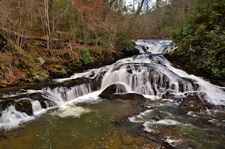
This is a really cool waterfall with a lot steps.  We climbed up a little ways along the waterfall until it got to steep and overgrown with rhododendron and then bushwhack up the side.  It was just a short ways further to the last waterfall on this creek, but incredibly difficult.  We could hear the waterfall from high above, but it was very tough to get back down to creek level.  Backtracking a bit, we finally found a safe way to get back down to the base of Rain Forest Falls.


At only 15 feet, it's the smallest falls on Bald Springs Branch, but really scenic, even with several huge trees fallen down on it.  After a couple pictures, we bushwhacked back up and found some semblance of an old logging road that we could follow back down to Fires Creek.  After crossing the creek and climbing back up to the forest road, it was just a mile back to the car.  Hiking back on the road, I spotted two trees near Fires Creek with shelf fungi growing out of them.


The one tree had purple fungi and the other had orange fungi.


Back at the car, we continued driving west past Murphy and Hiwassee Dam to Appalachia Lake.  We turned on the unpaved Prospect Road and drove to the property line to park on National Forest property and made an easy bushwhack down to lake level.  From here, there was a trail following North Shoal Creek up to the beautiful North Shoal Creek Falls.


In high water, this was a really beautiful waterfall.


There were also some really nice cascades on the creek downstream of the waterfall.


After a few pictures, we headed back.


We had planned to go to Tellico Falls as well while we were way out here, but with the high water level, we knew we'd never make it so headed back towards Franklin.  As we got towards Standing Indian, we got off the highway and took FR-67 past the campground for about 6 miles to the trailhead for Mooney Falls.  After the really tough hikes today, it was nice to visit an easy waterfall.  Mooney Falls is in two sections, though you can't see both from one point.


First we went to the upper section which is a long cascade with some mountain laurels blooming near the top.


Then we went down to the lower main section, a 20-foot drop.


Throughout the area, there were a lot of mountain laurel blooming.  So before heading back to Franklin, we made a quick stop at Big Laurel Falls, just a short ways back on FR-67.  From the parking area, we got on Big Laurel Falls Trail (#29) and crossed Mooney Creek on a footbridge.


Across the creek, we turned right to stay on Big Laurel Falls Trail.  We soon entered Southern Nantahala Wilderness and followed Nantahala River upstream towards its headwaters.


The Nantahala is formed at the confluence of Big Laurel Branch, Gulf Fork, and Kilby Creek.  We followed Big Laurel Branch just a short ways to the falls.


A better name would be Big Rhodo Falls as there were no mountain laurel here, just rhododendron.


It's still a beautiful waterfall and worth the easy hike since we were in the area.  After a couple pictures, we quickly hiked back as it was getting late.


After that, we headed back to Franklin.  Since it was late on a Sunday, most places were closed so we had dinner at Fatz before heading back to the hotel.