
Contact Information:
3042 Frank Parkway
Roaring Gap, NC 28668
Phone: (336) 957-8185
Email: stone.mountain@ncparks.gov
GPS Coordinates: 36.3873, -81.0273
Directions:
From points east, take I-77 north to exit 83. Follow US-21 north for about 13 miles and turn left on Traphill Road (SR 1002). After about 4 miles, turn right on John P Frank Parkway and follow to the park. From points west, take US-421 to NC-18 east to North Wilkesboro. Turn right on NC-268 and after about 3 miles, turn left on Airport Road. In about 4 miles, turn left onto Traphill Road (SR 1002). Follow Traphill Road for about 11 miles and turn left on John P Frank Parkway and follow to the park.
Map:
Trails:
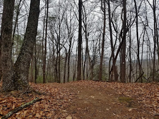
There are more than twenty miles of hiking trails and more than ten miles of equestrian trails in the park, taking in the many natural and historical attractions within the park.
Blackjack Ridge Trail:
Length: 1.5 miles (partial loop)
Difficulty: Moderate
Blaze: White Square
Black Jack Ridge Trail begins at the three-way intersection with Wolf Rock trail and Cedar Rock Trail. From here, the trail follows the ridge then loops back towards Cedar Rock. Especially in winter, when the leaves are down, there are nice views of Stone Mountain and Cedar Rock from the trail. The trail ends at Cedar Rock Trail near the intersection with Stone Mountain Loop Trail.
Bridle Loop Trail:
Length: 2 miles (loop)
Difficulty: Moderate
Blaze: Red Triangle
Bridle Loop Trail starts from the equestrian parking and makes a 2-mile loop. The Bridle Out and Back Trail splits off half way through.

Bridle Out and Back Trail:
Length: 4 miles (one way)
Difficulty: Moderate
Blaze: Red Triangles
Bridle Trail splits from the loop trail and runs with Middle Falls/Lower Falls Trail for a short ways, then runs concurrently with Mountains-to-Sea Trail to the park boundary. Near the eastern end, a spur trail leads out to an overlook an Combs Knob.

Cedar Rock Trail:
Length: 1.0 miles (one-way)
Difficulty: Moderate
Blaze: Red Circle
Cedar Rock is a short trail that runs from Wolf Rock Trail just east of Wolf Rock to Stone Mountain Loop Trail just east of the Hutchinson Homestead. Along the way, the trail crosses Cedar Rock, another large granite outcrop with excellent views of Stone Mountain.

Middle & Lower Falls Trail:
Length: 1.0 mile (one-way)
Difficulty: Moderate
Blaze: Blue Circle
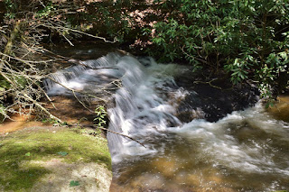
The Middle & Lower Falls Trail is a one-mile out-and-back trail that takes in two of the park's smaller waterfalls. The trailhead is off the Stone Mountain Loop Trail just west of Stone Mountain Falls. Immediately, the trail crosses a tributary of Big Sandy Creek. In just under a half-mile, a spur to the right leads to Middle Falls. There is a crossing of Big Sandy Creek right past the spur. The trail then heads up and down a ridge to the third creek crossing. At the point, the trail is also a bridle trail. The foot trail ends at Lower Falls, while the bridle trail continues.
Mountains-to-Sea Trail:
Length: 11.3 miles (one-way, length within park)
Difficulty: Strenuous
Blaze: White Circle
Segment 6 of the statewide Mountains-to-Sea Trail runs through Stone Mountain State Park. This section starts at Devil's Garden Overlook on the Blue Ridge Parkway and heads down into the park. The trail meets up with the Widow's Creek Trail near the backcountry campsites and continues down to Stone Mountain Road. The trail then climbs up to Wolf Rock Trail and Cedar Rock Trail and descends to Stone Mountain Loop. MST turns onto Middle Falls/Lower Falls Trail to the second creek crossing then follows the Bridle Out and Back Trail to the park boundary.
Stone Mountain Loop Trail:
Length: 4.5 miles (loop)
Difficulty: Strenuous
Blaze: Orange Circle
Stone Mountain Loop Trail is the most popular trail in the park, taking in many of the park's attractions along the way. There are two trailheads - the Upper Trailhead lot near the Visitor Center and the Lower Trailhead lot near the Hutchinson Homestead. From the Upper Trailhead lot, there is a short connector that leads up to an old chimney and a split in the trail, with left going to the falls and right going to Stone Mountain. Going right and following the trail in a counterclockwise loop, the trail heads towards the summit of Stone Mountain, crossing a few granite outcrops with views of Stone Mountain from the side. There are a couple switchbacks for the final ascent to the summit of Stone Mountain. The trail then heads back down the other side, passing over another rocky outcrop with open views before heading into the woods and descending via switchbacks. Near the bottom, the trail crosses the road that provides disabled access to Hutchinson Homestead and then passes near the Lower Trailhead. From this trailhead, the trail passes Wolf Rock Trail and moderately ascends along a tributary to Hutchinson Homestead, a restored 19th century farm typical to the area. For the next 3/4 of a mile, the trail follows a tributary downstream to the intersection with Lower Falls & Middle Falls Trail. Staying on the main trail, it follows Big Sandy Creek upstream to Stone Mountain Falls, the highest in the park. You'll need to climb around 300 stairs to get to the top of the waterfall and then just a short distance to the old chimney at the start of the loop.

Widow's Creek Trail:
Length: 2.5 miles (one-way)
Difficulty: Strenuous
Blaze: Orange Square
The Widow's Creek Trail follows Widow's Creek from the backcountry camping parking lot on the western end of the park up to the campsites. The trail runs with the Mountains-to-Sea Trail for most of its length, splitting as the Widow's Creek Trail heads to the campsites and the MST continues up the mountain.

Wolf Rock Trail:
Length: 1.5 miles (one-way)
Difficulty: Moderate
Blaze: Red Square
Wolf Rock Trail leads from the Stone Mountain Loop Trail near the Lower Trailhead parking lot to the intersection with Cedar Rock and Black Jack Ridge Trails. From Stone Mountain Trail, Wolf Rock Trail climbs up for a while then eventually levels off. A spur to the right leads out to an outcrop on Wolf Rock. This outcrop provides great views of the Blue Ridge Escarpment to the west and the ridges dividing the three main creeks running down from the Blue Ridge Parkway - Garden Creek, Widow's Creek, and Bullhead Creek. Past the spur, the trail descends to the remains of an old hunting shack. Shortly after this point, the trail ends at Cedar Rock and Blackjack Ridge Trails.

Points of Interest:
Besides the park's namesake, there are several other overlooks, waterfalls and other points of interest in the park.
Bullhead Creek Waterfall:
Bullhead Creek Waterfall is a small waterfall on the creek just upstream of the road.

Cedar Rock:
Cedar Rock is a scenic overlook with great views of Stone Mountain.

Hutchinson Homestead:
Hutchinson Homestead is a replica 19th century farm at the base of Stone Mountain.

Lower Falls:
Lower Falls is the lowest waterfall on Big Sandy Creek and can be accessed from Lower Falls & Middle Falls Trail.

Middle Falls:
Middle Falls is located on Big Sandy Creek downstream from Stone Mountain Falls.

Stone Mountain:
Stone Mountain, the park's namesake, is a granite monadnock on the edge of the Blue Ridge Escarpment.

Stone Mountain Falls:
Stone Mountain Falls, also called Little Falls, is the highest waterfall in the park.

Widow's Creek Falls:
Widow's Creek Falls is located near the western end of the park and is a popular swimming hole in the warmer months.

Widows Creek Upper Falls:
Upper Widows Creek Falls is a small, but scenic waterfall near the backcountry campsites.

Wolf Rock:
Wolf Rock is a granite outcrop with views looking west towards the Blue Ridge Mountains.

Wildlife:
Dimpled trout lily (Erythronium umbilicatum)

Sulphur shelf fungi (Laetiporus sulphureus) is an edible mushroom sometimes called "chicken of the woods" because it tastes like chicken.

Blog Entries:
04-Mar-2023: Elkin Waterfalls
18-Sep-2022: Stone Mountain Bridle Trails
17-Sep-2022: Stone Mountain Hike to the Parkway
06-Nov-2021: Fall Hike at Stone Mountain
02-Jun-2018: Stone Mountain Trails
14-Jan-2017: Winter Hike at Stone Mountain
15-Dec-2012: Winter Hike at Stone Mountain
12-May-2012: Widows Creek Trail
23-Oct-2011: Short Hike at Stone Mountain
External Links:
NC State Parks website: https://www.ncparks.gov/state-parks/stone-mountain-state-park
No comments:
Post a Comment