Hike Length: 4.2 miles
Estimated Time: 2 to 3 hours
Difficulty: Moderate
Location: Central District of Shenandoah National Park
Trail Users: Hiking only
Dogs: Yes
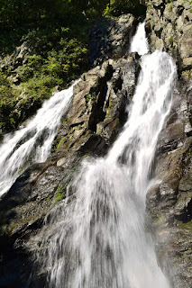
Features: Waterfalls (1)
Crowds: Moderate
Warnings: The rocks around waterfalls are very slippery.
Trailhead GPS: 38.38095,-78.51724
Waterfall GPS: 38.37942,-78.50052
Directions:
From Charlottesville, head north on US-29 for about 12 miles and turn left on US-33. Drive 14 miles and turn right to Skyline Drive. The park admission gate is here. Turn left onto Skyline Drive northbound and go 2.7 miles to the South River Picnic Area on the right at milepost 62.8. Drive around the loop and park near the restrooms and the trailhead for South River Falls Trail.
Map:

Hike Description:
South River Falls Trail crosses the Appalachian Trail in about 0.1 miles and then descends into the South River drainage. There are a few switchbacks before the trail crosses a tributary. In about 1.25 miles from the start, the trail leads to an overlook of the falls.

There's a lot of trees in the way so the view isn't great from here. To reach the base, continue a short ways to South River Falls Road and turn right. The old gravel road leads down to South River below the falls. A rocky path leads upstream to the base.

Blog Entries:
24-Aug-2018: South River Falls
External Links:
National Park Service website: https://www.nps.gov/thingstodo/south-river-falls.htm
No comments:
Post a Comment