
Map:
Trails:
Cedar Run Trail:
Length: 3 miles
Blaze: Blue (hiking only)
Difficulty: Difficult
Cedar Run Trail is a difficult 3-mile trail that leads from Hawksbill Gap Parking at milepost 45.6 on Skyline Drive to Whiteoak Canyon Trail near the Whiteoak Boundary Parking. This trail can be combined with Whiteoak Canyon Trail and Whiteoak Canyon Fire Road for a difficult 8-mile loop that passes nearly a dozen waterfalls. From the Hawksbill Gap parking, the trail immediately crosses Skyland-Big Meadows Horse Trail and begins to descend along Cedar Run. If the water level is high, the creek will begin soon after the start of the trail. Cedar Run is nearly a continuous set of drops and cascades and so the trail is quite steep. In just over 1.2 miles, the trail passes Cedar Run Canyon Falls. In another 0.5 miles, the trail passes Upper Cedar Run Falls and then Middle Cedar Run Falls after another 0.5 miles. Lower Cedar Run Falls is just another 0.1 miles. In about 2.5 miles, the Whiteoak-Cedar Run Link Trail splits to the left for those making the loop hike. The trail mostly levels off at this point and leads about another 0.5 miles to its end at Whiteoak Canyon Trail. The Whiteoak Boundary Parking is to the left in about 0.1 miles.

South River Falls Trail:
Length: 1.5 miles
Blaze: Blue (hiking only)
Difficulty: Moderate
South River Falls Trail starts from the South River Picnic Area at milepost 62.8 along Skyline Drive. In about 0.1 miles, the trail crosses the Appalachian Trail and begins descending into the South River drainage. There are a couple of switchbacks and then the trail crosses a tributary. In about 1.25 miles, the trail leads to an overlook for South River Falls. In another quarter-mile, it ends at South River Falls Road. Go right to reach the base of the waterfall.

Upper Hawksbill Trail:
Length: 1 miles
Blaze: Blue (hiking only)
Difficulty:Easiest
Upper Hawksbill Trail starts at the Upper Hawksbill Parking at milepost 46.5 on Skyline Drive. The trail leads 1 mile up to Byrds Nest No. 2 Shelter and the summit of Hawksbill. At 4050 feet above sea level, Hawksbill is the highest point in the park. Upper Hawksbill is the easiest route to the summit.

Whiteoak Canyon Trail:
Length: 4.6 miles
Blaze: Blue (hiking only)
Difficulty: Difficult
Whiteoak Canyon Trail starts from the Whiteoak Canyon Parking at milepost 42.6 on Skyline Drive. The trail descends and begins following Whiteoak Run downstream, reaching the canyon in about 2.3 miles. From this point, the trail becomes very steep and is heads down the canyon, passing 6 waterfalls and countless cascades and small drops. After the last waterfall, the trail crosses Tims River and levels off for the last mile. The trail ends at Whiteoak Boundary Parking on VA-600.

Skyline Drive:
Skyline Drive through the Central District runs from milepost 31.5 to 65.5. Below are some of the overlooks and points of interest along the drive.
Milepost 31.6 - Panorama Parking: Parking area near Thornton Gap with access to the Appalachian Trail and Marys Rock.
Milepost 33.0 - Hazel Mountain Overlook:

Milepost 35.0 - Pinnacles Overlook:

Milepost 40.5 - Thorofare Mountain Overlook:

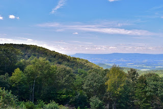
Milepost 44.0 - Crescent Rock Overlook: Crescent Rock Overlook provides views westbound into the Ida Valley, one of several tracts set up for residents displaced by the creation of the park.
Milepost 45.6 - Hawksbill Gap Parking: Trailhead parking for Cedar Run Trail and Lower Hawksbill Trail.
Milepost 46.5 - Upper Hawksbill Parking: Trailhed for Upper Hawksbill Trail.
Milepost 49.0 - Franklin Cliffs Overlook:

Milepost 53.0 - Naked Creek Overlook:

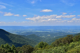
Milepost 55.5 - The Point Overlook: A short trail leads from the overlook down to a rock outcrop with views of the Shenandoah Valley.

Milepost 61.0 - Baldface Mountain Overlook:
Milepost 62.5 - South River Overlook: View of the South River drainage.

Milepost 62.8 - South River Picnic Area: Picnic area with access to South River Falls Trail.
Points of Interest:
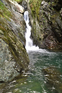
Cedar Run Canyon Falls:
Cedar Run Canyon Falls is waterfall on upper Cedar Run. This is one of many waterfalls on the Cedar Run-Whiteoak Canyon circuit hike. From Hawksbill Gap Parking at milepost 45.6, take Cedar Run Trail as it follows its namesake downstream. In about 1.2 miles, scramble down to the creek to see the waterfall. It tumbles in multiple streams over and under some huge boulders in the creek.

Cedar Run Upper Falls:
Upper Cedar Run Falls is a narrow slide waterfall in a beautiful canyon.
Cedar Run Middle Falls:
Middle Cedar Run Falls is a 50-foot waterfall on lower Cedar Run.

Cedar Run Lower Falls:
Lower Cedar Run Falls is a 30-foot waterfall on Lower Cedar Run.

South River Falls:
South River Falls is an 83-foot waterfall on its namesake.

Tims River Falls:
Tims River Falls is located just below Whiteoak Canyon.

Whiteoak Canyon Falls #1:
Whiteoak Canyon Falls #1 is the first waterfall in Whiteoak Canyon and marks the start of the canyon.

Whiteoak Canyon Falls #2:
Whiteoak Canyon Falls #2 is about 0.5 miles past the first one.

Whiteoak Canyon Falls #3:
Whiteoak Canyon Falls #3 is about 0.2 miles past the second one. The trail passes a rock outcrop with a view of the waterfall; I didn't make it to the base of this one.

Whiteoak Canyon Falls #5:
Whiteoak Canyon Falls #5 is upstream of #6, but there is no trail to it.

Whiteoak Canyon Falls #6:
Whiteoak Canyon Falls #6 is the last waterfall in the canyon and marks the end.

Blog Entries:
26-Aug-2018: Overall Run Falls and Hawksbill
25-Aug-2018: Cedar Run and Whiteoak Canyon
24-Aug-2018: South River Falls
03-Aug-2014: Old Rag
02-Aug-2014: Little Devil Stairs
No comments:
Post a Comment