
Hike Length: 4.2 miles
Estimated Time: 3 to 4 hours
Difficulty: Strenuous
Location: Central District of Shenandoah National Park
Trail Users: Hiking only
Dogs: Yes
Features: Waterfalls (7)
Crowds: High
Warnings: The rocks around waterfalls are very slippery.
Trailhead GPS: 38.55603,-78.38671
Waterfall GPS: 38.54265,-78.36773 (Upper Falls), 38.53779,-78.36237 (Middle Falls), 38.53739, -78.36148 (Lower Falls)
Directions:
From Charlottesville, head north on US-29 for about 12 miles and turn left on US-33. Drive 14 miles and turn right to Skyline Drive. The park admission gate is here. Turn left onto Skyline Drive northbound and go 19.7 miles to Hawksbill Gap Parking at milepost 45.6.
Map:

Hike Description:
Pick up Cedar Run Trail to follow its namesake downstream. In about 1.6 miles the trail passes by the top of the Upper Cedar Runs Falls. Just a little bit further, there is an obvious path down to the base. Since it's in a narrow canyon, you'll have to get in the creek to see it well. The pool at the base would probably make a nice swimhole.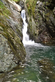
Continue on the trail another half mile and a short scramble path leads down to a rocky area at the top of Middle Cedar Run Falls. Cross the creek and climb down the rocks on the river-left side to the base.

Return to the trail and go another 0.1 miles to Lower Cedar Run Falls. A very steep scramble path leads down from the trail to the base of the lower waterfall.

Blog Entries:
25-Aug-2018: Cedar Run and Whiteoak Canyon
External Links:
National Park Service website: https://www.nps.gov/thingstodo/cedar-run-whiteoak-circuit.htm
No comments:
Post a Comment