
Map:
Trails:
Cow Creek Trail:
Cow Creek Trailhead is located at McGraw Ranch north of Estes Park. The trail starts at the far end of the ranch and North Boundary Trail splits to the left immediately. In 1.2 miles, Gem Lake Trail splits to the right and in 2 miles, Black Canyon Trail splits to the right. The first 2 miles or so of trail are through open meadow along Cow Creek and is a great place to spot wildflowers. The trail then heads into the woods for the last mile. Following Cow Creek more closely, the trail gets steeper and rocky towards the end, terminating at Bridal Veil Falls.

Mount Ida Trail:
Mount Ida is an unofficial and unmaintained trail, but is easy to follow and popular. Most of the trail is above the treeline so don't attempt to hike if there's a chance of thunderstorms. The trailhead is at Milner Pass along Trail Ridge Road at the continental divide. Follow Ute Trail past Lake Poudre as it switchbacks up to a split at 0.6 miles from the trailhead. Turn right on Mount Ida Trail. The trail gets above the treeline shortly and follows just below the continental divide. Because it's open, there are fantastic views from all along the trail. In about 2.5 miles, the trail passes a false summit at 12,150 feet then descends to the base of Mount Ida. From here, there's not much of a trail to follow, but it's pretty easy scrambling over the talus and boulders - just keep going up to the top. Wonderful views from the summit of Mount Ida - this was one of my favorite hikes in the park.

North Boundary Trail:
North Boundary Trail starts at the Cow Creek Trailhead at McGraw Ranch north of Estes Park. The trail starts at the far end of the ranch where Cow Creek Trail goes straight and North Boundary Trail goes right. The trail immediately leaves the park and enters Comanche Peak Wilderness. After steeply climbing up a ridge, it then descends down to West Creek, crossing on a footbridge. West Creek Falls Trail splits to the left after about 1.5 miles from the trailhead. Right after the split, the trail climbs another ridge then descends more gradually to Fox Creek. Shortly after crossing Fox Creek on a footbridge, the trail re-enters Rocky Mountain National Park. The trail continues to North Fork Trail but I've only hiked as far as the park boundary.

Odessa Lake Trail:
Odessa Lake Trail is a 4-mile trail that leads from Flattop Mountain Trail to Fern Lake. The southern end of the trail splits from Flattop Mountain Trail, about 1 mile from Bear Creek Trailhead. The trail leads about 2 miles along the southern flank of Joe Mills Mountain. Unmarked side trails lead to Two Rivers Lake and Lake Helene. After the side trail to Lake Helene, the trail descends into Odessa Gorge. The trail leads down and past Odessa Lake, with a short spur leading up to the lake. After the spur, the trail follows Fern Creek downstream to Fern Lake and the end of the trail.

Tundra Communities Trail:
Tundra Communities Trail is a 1-mile paved trail that leads through alpine tundra above the treeline. This is one of the only ways to hike in this environment without a strenuous mountain climb. The trailhead is along Trail Ridge Road near Rock Cut. The trail heads up and levels out as it approaches Mushroom Rocks, ending at another rock outcrop.

West Creek Falls Trail:
West Creek Falls is a 0.6-mile spur of North Boundary Trail that leads to its namesake waterfall. North Boundary Trail starts at the Cow Creek Trailhead. In about 1.5 miles, after crossing West Creek on a footbridge, West Creek Falls trail splits to the left from North Boundary Trail. The trail follows West Creek upstream to the waterfall.

Trail Ridge Road:
Trail Ridge Road (US-34) is the highest paved through road in the United States. There are several scenic overlooks to stop at along the road as well as a number of trailheads.
Rainbow Curve is 12.1 miles west of Beaver Medicine Visitor Center and provides great views looking east into the Fall River valley, especially at sunrise.

Lava Cliffs is 20.9 miles west of Beaver Medicine Visitor Center.

Gore Range Overlook, 22 miles west of Beaver Medicine Visitor Center or 1 mile east of Alpine Visitor Center.

Lakes:
There are more than 100 alpine lakes throughout the park.
Bear Lake:
Bear Lake is located at the end of Bear Lake Road in the heart of the park. It is one of the most popular areas of the park and the parking lot can fill quickly. An easy half-mile trail leads around the lake from the parking area.

Bluebird Lake:
Bluebird Lake is a beautiful high elevation lake in the southeast of the park and can be access from the Wild Basin trailhead. The hike is more than 12 miles round trip and challenginer. Follow the Thunder Lake Trail for about 3 miles to Bluebird Lake Trail and go left. Past the spur to Ouzel Lake, the trail gets steeper and there was a wonderful wildflower display when we visited. The last part of the hike involved navigating up a small snow field.

Fern Lake:
Fern Lake is located in the heart of the park. The trailhead is at the end of Moraine Park Road off Bear Lake Road. The Fern Lake Trail leads about 4 miles to the lake.

Lake of Glass:
Lake of Glass is a spectacular high elevation lake on Icy Brook. The lake can be accessed from Glacier Gorge Trailhead. Follow the trail up past Alberta Falls and North Longs Peak Trail. Shortly after the split with Mills Lake, the trail leads to the Loch and around the northwestern shore towards. After the split with Andrews Glacier, Timberline Falls will be visible from the trail. As you approach the waterfall, you'll have to climb up the chute to the right of the Timberline Falls. Lake of Glass is just above the waterfall.

Lake Helene:
Lake Helene is a high elevation lake at the headwaters of Fern Creek. The lake can be most easily accessed from Bear Lake Trailhead. Follow Flattop Mountain Trail for about 1 mile to a split and go right towards Odessa Lake. In about 3 miles from the trailhead the trail will begin to descend into Odessa Gorge. Just before it does, an unmarked side trail to the left goes out to the lake.

The Loch:
The Loch is a lake on Icy Brook and can be accessed from the Glacier Gorge Trailhead. Follow the trail up past Alberta Falls and North Longs Peak Trail. Shortly after the split with Mills Lake, the trail leads to the Loch and around the northwestern shore towards Sky Pond.

Odessa Lake:
Odessa Lake is along Fern Creek. It is about halfway between the Bear Lake and Fern Lake trailheads so can be accessed from either or do a shuttle hike between the two. From Fern Lake Trailhead, follow Fern Lake Trail for about 4 miles to Fern Lake. Across the bridge over Fern Creek at the foot of the lake, Odessa Lake Trail starts and leads about 1 mile to a split. The right fork is a spur to Odessa Lake.

Ouzel Lake:
Ouzel Lake is located in the southeast of the park in the Wild Basin area. From the trailhead, follow Thunder Lake Trail for about 3 miles and turn left onto Bluebird Lake Trail. In about a mile, Ouzel Lake Trail splits to the left and leads a half-mile to the lake.

Poudre Lake:
Poudre Lake is located at Milner Pass along Trailridge Road at the continental divide.

Sky Pond:
Sky Pond is a spectacular lake below Taylor Glacier. The hike is challenging, about 10 miles round trip and the trailhead is Glacier Gorge. Follow the trail up past Alberta Falls and North Longs Peak Trail. Shortly after the split with Mills Lake, the trail leads to the Loch and around the northwestern shore towards. After the split with Andrews Glacier, Timberline Falls will be visible from the trail. As you approach the waterfall, you'll have to climb up the chute to the right of the Timberline Falls. Continue past Lake of Glass to the end of the trail at Sky Pond.

Two Rivers Lake:
Two Rivers Lake is a beautiful high-altitude lake at the headwaters of Mill Creek. The lake can be most easily accessed from Bear Lake Trailhead. Follow Flattop Mountain Trail for about 1 mile to a split and go right towards Odessa Lake. In about 3 miles from the trailhead, an unmarked side trail to the left goes out to the lake.

Mountains:
There are more than 60 mountain peaks in the park with elevation over 12,000 feet.
Mount Ida:
Elevation: 12,874 feetMount Ida is located in the center of the park along the Continental Divide. The mountain can be accessed from Milner Pass trailhead along Trail Ridge Road about 5 miles west of Alpine Visitor Center. The hike begins following Ute Trail for about 0.6 miles to a split. Go right for Mount Ida Trail, an unmaintained trail, but easy to follow. The trail soon gets above the treeline and follows the continental divide up to the summit. The last mile of trail is over a talus field and can be hard to follow; just keep going up. The round trip hike is just over 9 miles with about 2500 feet of elevation gain. It's moderately difficult but great views and was one of my favorite hikes in the park. Most of the hike is exposed so be aware of the weather and avoid if there's a chance of thunderstorms.

Waterfalls:
Alberta Falls:
Alberta Falls is a really pretty 30-foot waterfall on Glacier Creek in the Bear Lake area.

Bridal Veil Falls:
Bridal Veil Falls is a 20-foot waterfall on Cow Creek in the northern part of the park.

Calypso Cascades:
Calypso Cascades is a tall cascading waterfall in the Wild Basin area of the park.

Chasm Falls:
Chasm Falls is a waterfall on Fall River where it flows through a narrow chasm.

Copeland Falls:
Copeland Falls is a small waterfall in two sections on North Saint Vrain Creek access from the Wild Basin area of the park.

Fern Falls:
Fern Falls is a beautiful 60-foot waterfall on Fern Creek.

Glacier Falls:
Glacier Falls is a small waterfall on Glacier Creek. The trailhead is Glacier Gorge Trailhead. It's over 4 miles round trip to the waterfall and would only be worth for the hike to Mills Lake. Glacier Gorge Trail follows Glacier Creek upstream past Alberta Falls and the intersection with North Longs Peak Trail. At about 2 miles, the trail to the Loch and Sky Pond splits; go left towards Mill Lake. As the trail climbs up the rocks along Glacier Creek, Glacier Falls is down to the left. There's not a good view from the cliffs up here. It might be possible to reach the base from earlier on the trail.

Glacier Gorge Falls:
Glacier Gorge Falls is an unnamed waterfall on Glacier Creek. The starting point is the Glacier Gorge Trailhead. Glacier Gorge Trail initially descends and crosses Chaos Creek then ascends to follow Glacier Creek upstream. In under a mile, the trail passes Alberta Falls then heads away from the creek. Where it swings back to the creek, Glacier Gorge Falls is just below the trail. It's a very steep climb down to the creek for a good view. Since the waterfall is unnamed, I called it Glacier Gorge Falls.

Grace Falls:
Grace Falls is a tall waterfall dropping from the north face of Notchtop Mountain. The trailhead is at Bear Lake. Follow Flattop Mountain Trail for about a mile to a split and go right towards Odessa Lake. In about 3 miles from the trailhead, the trail descends into Odessa Gorge. Look across the gorge to Notchtop Mountain and the waterfall can be seen. It's fed by snowmelt from the mountain, so best to visit in the spring when it's flowing the most.

Horseshoe Falls:
Horseshoe Falls is a waterfall on Raging River at the alluvial fan formed by the Lawn Lake flood.

Marguerite Falls:
Marguerite Falls is a cascading waterfall on Fern Creek, just downstream of Fern Lake.

Ouzel Falls:
Ouzel Falls is a beautiful 40-foot waterfall on Ouzel Creek in the Wild Basin area of the park.

Timberline Falls:
Timberline Falls is a 100-foot waterfall at the outflow of Lake of Glass.

West Creek Falls:
West Creek Falls is a two-tiered waterfall in the northern part of the park.

Wildlife:
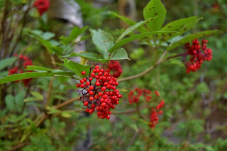
Red elderberry (Sambucus racemosa) is a small tree that produces red berries eaten by birds, but the raw berries are poisonous to humans.
White campion (Silene latifolia) is an introduced species with white flowers.

White marsh marigold (Caltha leptosepala)

Spruce-fir fleabane (Erigeron eximius)

Alpine gentian (Gentiana newberryi)

American bistort (Bistorta bistortoides)

Pearly pussytoes (Antennaria anaphaloides)

Rocky Mountain hemlock parsley (Conioselinum scopulorum)

Western Indian paintbrush (Castilleja occidentalis)

Ross' avens (Geum rossii)

Mountain goldenrod (Solidago multiradiata)

Common blanket flower (Gaillardia aristata) is a very beautiful flower, commonly used as an ornamental.

Splitleaf Indian paintbrush (Castilleja rhexiifolia)

Pineywoods geranium (Geranium caespitosum)

Elephanthead lousewort (Pedicularis groenlandica)

Colorado blue columbine (Aquilegia coerulea)

Tall fringed bluebells (Mertensia ciliata)

Aspen fleabane (Erigeron speciosus)

Wild bergamot (Monarda fistulosa)

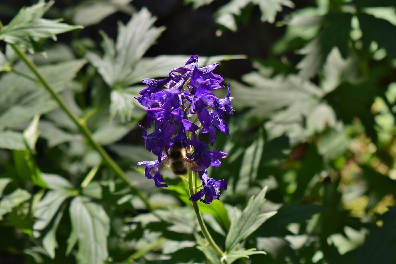
Barbey's larkspur (Delphinium barbeyi)

Western monkshood (Aconitum columbianum)

Red admiral (Vanessa atalanta)

White-lined sphinx (Hyles lineata)

Pine grosbeak (Pinicola enucleator)

Hairy woodpecker (Leuconotopicus villosus)

Black-billed magpie (Pica hudsonia)

White-tailed ptarmigans (Lagopus leucura) live primarily on arctic tundra above the treeline. In the summer, their feathers a grey and brown to blend in with the rocks, but change to white in the winter.

Dusky grouse (Dendragapus obscurus)

American pika (Ochotona princeps)

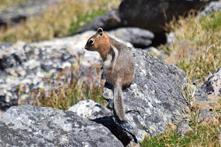
Golden-mantled ground squirrel (Callospermophilus lateralis)
Yellow-bellied marmot (Marmota flaviventris)

Mule Deer (Odocoileus hemionus)

Elk (Cervus canadensis)

Moose (Alces alces)

30-Aug-2019: Bluebird Lake
29-Aug-2019: Sky Pond
28-Aug-2019: Bear Lake to Fern Lake
27-Aug-2019: Mount Ida
26-Aug-2019: Rocky Mountain Wilderness Waterfalls
National Park Service website: https://www.nps.gov/romo/index.htm
Wilderness.net website: https://wilderness.net/visit-wilderness/?ID=745

White campion (Silene latifolia) is an introduced species with white flowers.

White marsh marigold (Caltha leptosepala)

Spruce-fir fleabane (Erigeron eximius)

Alpine gentian (Gentiana newberryi)

American bistort (Bistorta bistortoides)

Pearly pussytoes (Antennaria anaphaloides)

Rocky Mountain hemlock parsley (Conioselinum scopulorum)

Western Indian paintbrush (Castilleja occidentalis)

Ross' avens (Geum rossii)

Mountain goldenrod (Solidago multiradiata)

Common blanket flower (Gaillardia aristata) is a very beautiful flower, commonly used as an ornamental.
Splitleaf Indian paintbrush (Castilleja rhexiifolia)

Pineywoods geranium (Geranium caespitosum)

Elephanthead lousewort (Pedicularis groenlandica)

Colorado blue columbine (Aquilegia coerulea)

Tall fringed bluebells (Mertensia ciliata)
Aspen fleabane (Erigeron speciosus)

Wild bergamot (Monarda fistulosa)

Barbey's larkspur (Delphinium barbeyi)
Western monkshood (Aconitum columbianum)

Red admiral (Vanessa atalanta)

White-lined sphinx (Hyles lineata)

Pine grosbeak (Pinicola enucleator)

Hairy woodpecker (Leuconotopicus villosus)

Black-billed magpie (Pica hudsonia)

White-tailed ptarmigans (Lagopus leucura) live primarily on arctic tundra above the treeline. In the summer, their feathers a grey and brown to blend in with the rocks, but change to white in the winter.
Dusky grouse (Dendragapus obscurus)

American pika (Ochotona princeps)
Golden-mantled ground squirrel (Callospermophilus lateralis)

Yellow-bellied marmot (Marmota flaviventris)

Mule Deer (Odocoileus hemionus)
Elk (Cervus canadensis)

Moose (Alces alces)
Blog Entries:
30-Aug-2019: Bluebird Lake
29-Aug-2019: Sky Pond
28-Aug-2019: Bear Lake to Fern Lake
27-Aug-2019: Mount Ida
26-Aug-2019: Rocky Mountain Wilderness Waterfalls
External Links:
National Park Service website: https://www.nps.gov/romo/index.htm
Wilderness.net website: https://wilderness.net/visit-wilderness/?ID=745
No comments:
Post a Comment