
Hike Length: 1.6 miles
Estimated Time: 1 to 2 hours
Difficulty: Moderate
Location: Telluride Area (Norwood Ranger District of Uncompahgre National Forest)
Trail Users: Hiking
Dogs: Yes
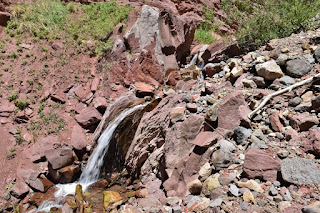
Features: Waterfalls (1)
Crowds: High
Warnings: The rocks around the waterfall are very slippery.
Trailhead GPS: 37.93750,-107.81958
Waterfall GPS: 37.94332,-107.81033
Estimated Time: 1 to 2 hours
Difficulty: Moderate
Location: Telluride Area (Norwood Ranger District of Uncompahgre National Forest)
Trail Users: Hiking
Dogs: Yes
Features: Waterfalls (1)
Crowds: High
Warnings: The rocks around the waterfall are very slippery.
Trailhead GPS: 37.93750,-107.81958
Waterfall GPS: 37.94332,-107.81033
Directions:
From Montrose, head south on US-550 for about 26 miles to Ridgeway and turn right on CO-62 west. Go 23 miles to Placerville and turn left on CO-145 south. In 12.7 miles, take the second exit in the roundabout to stay on CO-145. In another 2.9 miles, go straight through the roundabout to Colorado Avenue and turn right in 0.2 miles on South Tomboy Drive. In 0.2 miles is Carhenge, I think it's the closest free, public parking to the trailhead.
Map:

Hike Description:
From Carhenge, cross the bridge and follow South Tomboy Drive to Colorado Avenue and turn right. In 0.4 miles, turn left on North Aspen Street and follow to the end for the trailhead for Cornet Creek and Jud Wiebe Trail. Jud Wiebe Trail goes left and crosses the creek on a footbridge while Cornet Creek goes straight to follow the creek upstream. There are some small cascades on the creek.
No comments:
Post a Comment