Hike Length: 5.8 miles
Estimated Time: 3 to 4 hours
Difficulty: Moderate
Location: Salida Ranger District of San Isabel National Forest
Trail Users: Hiking
Dogs: Yes
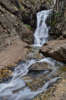
Features: Waterfalls (1)
Crowds: Moderate
Warnings: The rocks around the waterfalls are very slippery.
Trailhead GPS: 38.67216,-106.16149
Waterfall GPS: 38.65066,-106.19240
Estimated Time: 3 to 4 hours
Difficulty: Moderate
Location: Salida Ranger District of San Isabel National Forest
Trail Users: Hiking
Dogs: Yes
Features: Waterfalls (1)
Crowds: Moderate
Warnings: The rocks around the waterfalls are very slippery.
Trailhead GPS: 38.67216,-106.16149
Waterfall GPS: 38.65066,-106.19240
Directions:
From Buena Vista, head south from on US-285 for about 9 miles and turn right on County Road 270. In 1.5 miles, go straight through the 4-way stop to get on CR-272. Continue 2 miles and turn left to stay on CR-272. Drive 1.6 miles and the trailhead parking will be on the right.
Map:

Hike Description:

Blog Entries:
04-Jul-2019: Rafting the Numbers
External Links:
US Forest Service website: https://www.fs.usda.gov/recarea/psicc/recreation/ohv/recarea/?recid=12639
No comments:
Post a Comment