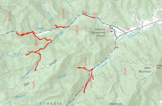
Thursday, we decided to head back to Coweeta Hydrologic Laboratory and explore the area a little more. We first drove up Ball Creek Road and parked at the gated FR-83E. Across the road, a short road headed up Henson Creek, but it fizzled out and the bushwhacking would have been tough. So we followed 83E upstream along Ball Creek.

There were some weirs along tributaries and other research equipment but this road ended shortly too. We drove up a ways further on Ball Creek Road and then headed down to Shope Fork Road and parked at the gated FR-83D. We hiked a mile or two along this road as it followed Cunningham Creek upstream.

Eventually, there wasn't much more elevation gain for this creek and we turned around. There was one nice little cascade on the creek, but it was cluttered with rhododendron.

There was another weir on Mill Creek and some other research going on here.

Back at Shope Fork Road, we hiked along the road as there were some nice cascades and drops on the creek.

It was quite steep getting down to creek level for a picture though.

We made one more stop at the Shope Fork weir before taking off.

From here, we headed back towards Franklin.
We stopped at Lazy Hiker and got dinner from the food truck and had an early dinner at the brewery. There was still some time before sunset when we finished eating, so made a quick stop to see Camp Branch Falls just off Wayah Road.

We took a little break down here and then climbed back up to the main trail. In winter there was a view of the falls and a cave high above.

It was just a couple hundred feet to Upper Camp Branch Falls. It would be a nice waterfall, but it's covered in downfall.

We made it back to the car just before sunset and headed back to Franklin.

No comments:
Post a Comment