Friday, July 31, 2020

Brush Creek and Pipestem

It had rained all night, but lightened a bit by morning.  Since there had been so much rain, we headed back to Mash Fork Falls for a couple pictures in higher water.


It was definitely a lot higher than it had been the previous evening.


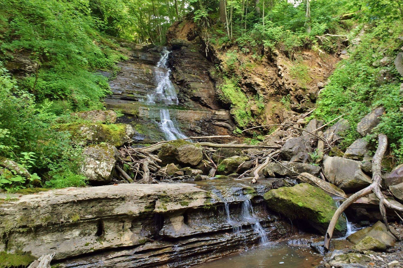
Then we continued to Brush Creek Falls.  After getting our stuff together, we started hiking down the trail.  It wasn't long until we came to Brush Creek Falls.  It's a big one and I could tell it was spectacular from the top.


We continued on the trail a bit and found a path leading down to the base.


The force of the waterfall was very impressive.


After some pictures, we continued on the trail.  There were some white wood aster blooming along the trail.


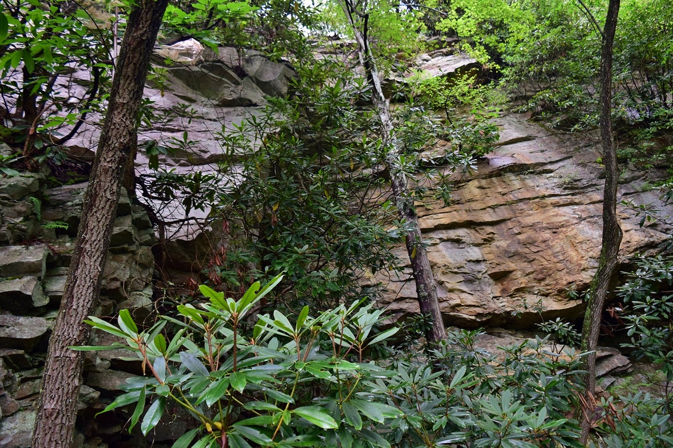
It soon entered Brush Creek Preserve and followed its namesake downstream passing by some massive cliffs.


Falls Trail continued to the confluence with Bluestone River and then turned right to follow the river downstream about a half-mile to the end where Whiteoak Creek flowed into Bluestone.


Whiteoak Creek Falls was just upstream.


It was a pretty nice waterfall, but hard to see all the sections.  I made it up to the middle section.


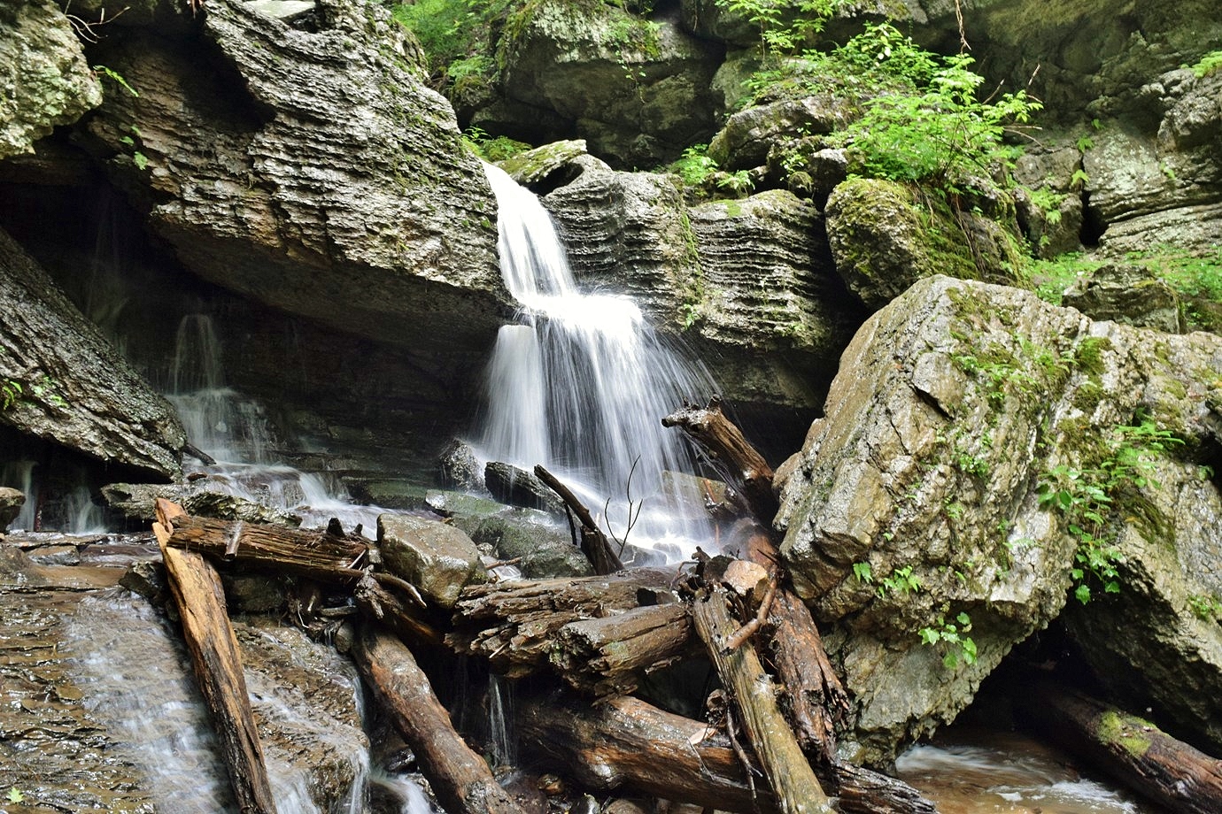
From here, it was a tricky rock scramble to the upper section and the rocks were very wet and slippery from the rain.  I decided against going up any further and we just enjoyed the waterfall from the base.  Hiking back, we spotted some common self-heal flowering along the trail.


As we passed Brush Creek Falls, it was now quite crowded, so glad we arrived early.


Next, we headed to Pipestem Resort State Park and parked at the Nature Center.  Just behind the Nature Center were some historic log cabins that had been relocated to the park.


County Line Trail began just behind here and descended steeply at first, then leveled off.  Some pearl oyster mushrooms were growing on a tree.


We also spotted some shrubby Saint John's wort flowering.


In just over a mile, we made it to the overlook for Indian Branch Falls.


With summer foliage, the view from the overlook was poor.  I scouted around but sheer cliffs prevented any reasonable way down to creek level.  We will have to try again without the dog.  Just above the waterfall were some nice cascades on Indian Branch.


The view of the top of the falls here was better than the view from the overlook.


Our next stop was at the Canyon Rim Center, where the aerial tram runs down deep into the gorge.  But we weren't staying at the Mountain Creek Lodge and so got on the Canyon Rim Trail.  This trail led steeply down for just over half a mile to Heritage Point.


The views here were just great.


We could see Mountain Creek Lodge far down below.


Dark clouds were rolling in so we started heading back, but got caught in a small downpour.  But it didn't last long and when we got back to the Canyon Rim Center, Alex had an ice cream cone!  Then we headed to McKeever Lodge and had pizza for dinner outside.  Heading back, we made one more stop at the trailhead for Pipestem Knob Trail.  A short paved trail led up to the lookout tower on Pipestem Knob.


The views from up here were fantastic.


No one else was up here so we hung out for a while enjoying the views.  A couple bugs were crawling around at the top of the tower.


A leaf beetle and a leaf-footed bug were enjoying the tower as much as we were.


After a while, we headed back.


From here, we headed back to Camp Creek State Park.  After settling into camp, I went for a hike on the Blue Jay Spur that started from our campsite.  It headed up steeply to meet with Farley Ridge Trail and drop back down.  I took Horse Bypass Trail to head back to camp.  A number of wildflowers were blooming in the evening light, including some beautiful coneflower.


I also stopped for a picture of the Campbell Millstones.


It was just a short hike on the road back to camp.


Sandy had built a fire and then we went to bed.

Thursday, July 30, 2020

Overlooks and Falls in New River Gorge

Thursday, we took a long weekend to take Alex for some camping in West Virginia.  We left early in the morning and drove up to West Virginia and got off near Athens to take WV-20 up to the gorge.  Right after Pipestem Resort State Park, we made a quick stop at Pipestem Falls Park.  It's a little roadside park with a small waterfall.  From the park, the view of Pipestem Falls was poor and mostly obstructed by trees.  We headed up a short trail above the waterfall to see some nice cascades above the main drop.


But there wasn't much to see of the main waterfall from here.


So I went back to the parking area and found a super steep scramble path down to the base.  With loose rocks and lots of garbage, it was treacherous going down.  Once at the creek, I rock-hopped up to the base of Pipestem Falls.


In low water, it wasn't too exciting, but I'd like to make another visit when the water is higher.


After some pictures, I made the steep climb back up to the road.


From here, we continued into New River Gorge National River and made a stop at Brooks Falls.


It's more of a rapid than a waterfall but pretty impressive with being so wide.


We found a nice spot to go out on the rocks and stop for a snack.


The river is really scenic here as it transitions from a wide mountain river to narrow whitewater gorge.


We had planned to hike Bad Branch Trail to see the waterfalls, but the water level was so low, it wouldn't have been worth it.  Instead, we headed to Sandstone Falls.  Like Brooks Falls, it's a river wide waterfall, but closer to 15 to 20 feet.  We first took the boardwalk out to the overlook of the main falls.


Some paths led from the boardwalk around the islands below the falls with some great closer views.


In low water, Sandstone Falls might look nicer than in high water.  Instead of one constant flow, it was dozens of smaller waterfalls and reminded me of the waterfalls in Plitvice Lakes in Croatia.


There were a number of summer wildflowers blooming on the small islands.


These islands make up the rare Appalachian Riverside Flatrock Community, an unusual ecosystem found only a few places in West Virginia.


Wild sweetwilliam, nodding onions, and shrubby St. John's Wort were flowering.


It started to rain as we got to the larger main falls and a closer view than from the overlook.


So we headed back to the boardwalk and found a path leading to a small beach further downstream.


The rain died down and we took a hike around the short Island Loop Trail around the largest island below the falls.  Back at the boardwalk, I stopped for one more view of Sandstone Falls.


Then we headed back to the car and continued on.


Our next stop was at the Grandview area of New River Gorge just north of I-64.  The rain had died down but it was cloudy.  We first stopped at the Main Overlook, which had a spectacular view of a horseshoe bend in the river.


The clouds hanging over the mountains were just beautiful.


We waited here for a bit and eventually a train passed by far below.


From here, we got on Castle Rock Trail.  There were some huge sulphur shelf mushrooms along the trail.


This rocky trail passed below some huge cliffs below the rim.


There were a few small caves in the cliffs.


It was a rocky and narrow trail but made for a great hike.


The trail ended at Canyon Rim Trail and we turned right to continue along the rim.  It was mostly forested but there were a couple spots with a break in the trees for a view of the gorge far below.


The trail ended at Turkey Spur Overlook and the rain had started again.  With this rain and slick wooden steps, we took turns going up so Alex didn't have to climb.  There are three overlooks up here and two black vultures were perched at the first.


Despite the rain, the views from up here were really nice.


With three overlooks, there were views in all directions.


Heading back down, Alex and I stood under a rock overhang to stay dry while Sandy checked out the overlook.  The rain died down again on the hike back.  We made a stop on the hike back at the North Overlook, which is just above the rocky cliffs we had passed early.


Initially, it was cloudy but a beautiful view.  Slowly, more clouds rolled in and it became a complete whiteout.


Finishing up Grandview Rim Trail, I spotted another sulphur shelf, a different species I think.


Before we left, I wanted to hike the short tunnel trail.


There's a tunnel in the sandstone rock outcrop, but it's closed for safety.


The short loop trail was very nice even with the tunnel closed and seemed cooler than the rest of the area.


After finishing the loop, we headed back to the car and started heading south.


Passing Little Beaver State Park, we made a quick stop.  The historical dam was very pretty.


I climbed up to the lake and then we took off.


After checking in at Camp Creek State Park and Forest, we set up camp at the Blue Jay Campground site number 12.  This one was across from all the other campsites so great for social distancing.  It was still raining, so we decided to hit up some of the waterfalls in the park.  First we stopped at Mash Fork Falls.


Despite the rain, the water flow was pretty low.  It was very easy to rock hop around and view the falls from different angles.  Then we headed back to camp and hiked to Campbell Falls.


This one was really scenic, even in low water.


The top of the waterfall was really interesting, with flat rocks with deep cracks through which the water was flowing.


The rain picked up so we headed back.


With heavy rain all night, we just stayed in the tent for the rest of the night.