For the Thanksgiving holiday, Sandy and I had to head up north to visit her relatives. So of course, we had to get some waterfalls on the way! We would first be heading to Forest Hill, Maryland to visit her aunt and uncle. We left early Saturday morning and started heading north on I-85 and I-95 through Virginia. Near Washington, DC, we got on I-495 and took Clara Barton Parkway to the Great Falls Tavern area of Chesapeake & Ohio Canal National Historic Park. After paying admission and parking, we headed out past the old tavern along the towpath following the canal. After passing the Mercer canal boat that was propped up in the canal, we turned right to head towards Great Falls. The Olmsted Island Bridges are a series of wooden bridges and boardwalks that extend from the towpath to the far end of Olmsted Island.
The Potomac River is turbulent here, tumbling down cascades and rocky falls as it flows past the island. We followed the bridges out to the far end of Olmsted Island at a viewing platform for Great Falls.
Great Falls is a surprisingly large waterfall on the Potomac River at the fall line - where the Piedmont transitions to the coastal plain. Even more surprising is its close proximity to Washington, DC, only about 15 miles. The falls consists of a series of cascades totaling about 76 feet in height with a huge volume of water.
We had a nice panoramic view of the falls from the overlook, but it was from a distance. Visitors are not allowed off the wooden viewing platform for a closer look. It was also quite crowded, so we got a few pictures and then headed back. We had forgotten to pick up lunch, so we quickly headed back to the car and got some snacks, then headed back down the towpath.
Right before the stop gate, we turned to get on Billy Goat Trail A, which heads out onto the rocky Bear Island. This trail is a lot of fun as it involves much scrambling over rocks and boulders and even a section where we would have to scale a cliff. The trail starts off moderate - rocky ground, but mostly flat and not too hard to follow.
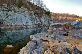
There were a couple nice spots with great views of Mather Gorge and Potomac River and the Virginia park on the other side.
About half-way, we got to the cliff. The main path up and down goes through a crevasse in the cliff to provide some footing. There were a bunch of people coming down and we didn’t really want to wait, so we just climbed up along the side to make it to the top. We continued along, eventually descending down to river level at Purplehorse Beach.
I climbed out onto the rocks for some more pictures of the river, but there was a good bit of ice out here and very slippery. Then, we finished up the trail, arriving back at the towpath about a mile down from where we had gotten off of it near Widewater.
As we started hiking back, we stopped at a little pond to see a beaver walking across.
The pond was partially frozen and the beaver was making his way across, slipping and sliding as he went. At one point, the thin ice broke and he splashed into the water, then made his way to the edge. He was poking around looking for food and eventually climbed up to the towpath to nibble on vegetation right alongside the trail.
We got some pictures and video of this beaver, who didn’t seem to be afraid of humans at all. Then we finished walking back up the towpath to the tavern and returned to our car. This is a great little park, right outside Washington, DC, and I’m glad we made it here. We’ll have to come back to explore more again some time soon when we have more time. From here, we finished the drive up to Forest Hill and had dinner with Sandy’s family before going to bed early.


No comments:
Post a Comment