Friday, November 28, 2014

Devil's Marbleyard

Sandy had to be back at work on Saturday, so we left Pennsylvania Friday morning. Given holiday traffic, we decided to avoid I-95 and take I-81 south instead. It would add a little distance but potentially save a lot of hassle if I-95 was backed up. We stopped for breakfast at Dunkin Donuts before hitting the road. Although there was much snow in the ground still in Pennsylvania and northern Virginia, as we headed further south, it got lighter and lighter and soon was only visible high up on mountain peaks. Near Natural Bridge, we got off the highway and headed towards the James River Face Wilderness in Jefferson National Forest. We were planning a hike to Devil’s Marbleyard to break up the long drive. The small parking area for Belfast Trail was full so we had to park a little further down the road and hike back to the trailhead. It was a little over a mile heading upstream along Belfast Creek to Devil’s Marbleyard. Although there was no snow on the ground when we started, there was quite a bit by the time we reached the boulder field.


Fortunately, the exposed boulders had received enough sunlight that there was no snow here.


We got off the trail and scrambled around on the rocks for a few minutes before making our way back. Along the hike up, the elevation gain had kept us warm. But once out on the exposed rocks, it was quite chilly with the wind blowing.


Once we got too cold, we started making our way back and finished up the drive home.

Thursday, November 27, 2014

Peace Valley

Thursday was Thanksgiving and by now, the snow had ended. The roads were cleared so in the morning, Sandy and I headed to Peace Valley for a walk around Lake Galena. We parked at the Peace Valley Nature Center and started walking the hike/bike path around the lake. It was a chilly morning, but the sky was clear and the views of the lake were great.


We saw large numbers of Canada geese flying through the air and floating across the lake. Despite the snow and holiday, there were quite a few other people on the trail this morning. When we finished up the loop back at the nature center, we hiked along a few of the nature trails. Unlike the main trail around the lake, there was no one else on these trails.


No people at least. We did see some deer, including a fawn with her mother.


After a nice hike and working up an appetite, we headed back and had a big Thanksgiving dinner. We would be heading home in the morning, so we started packing our stuff up in the morning.

Tuesday, November 25, 2014

Delaware Water Gap

Tuesday morning, we woke up very early and headed out well before sunrise. So early in fact, that nowhere was open for us to get breakfast. Around 630, we stopped at a Panera in Easton for a quick breakfast, then continued heading north to the Delaware Water Gap National Recreation Area. From I-80, we went north on US-209 through the water gap for about 20 miles to Raymondskill Road and parked at the trailhead for the falls. Raymondskill Falls consists of three tiers and combined, form the highest waterfall in Pennsylvania. We hiked the short trails to see the different tiers, starting at the upper falls, which is a cascade before the big drop.


We could see the top of the main drop and tell it was a big one, but needed to go down for a good view.


So we headed down the wooden boardwalks for views of the middle drop. It was quite impressive and we spent a while enjoying the view.


Right past here is the lower drop, but there weren’t very good views of it, so we hiked around to see the lower drop.


It was partially obscured by trees, but still a powerful falls and worth a closer look. Next to the lower section was a thin horsetail falls cascading down. I imagine this little falls wouldn’t exist in dry conditions. From here, we hiked back to the parking area, but wanted to get another waterfall before we took off. We crossed the street and turned left to get on the yellow-blazed Hackers Trail and followed it for about a mile to Hackers Falls. Shortly before we reached the waterfall, we could hear water crashing and followed a path to the creek, but this was just a long slide, not the waterfall. So we continued just a short ways and could soon see the waterfall from the trail.


With the foliage down, it was easy to see from a distance. We got off the trail and scrambled out on the rocks for a view of this waterfall.


Although not particularly big, it was a very scenic waterfall and worth the short hike from Raymondskill. About half way back, we got on the yellow-and-white-blazed Logger Path to make a loop back to the parking area. We turned right on Cliff Trail and made a short stop at the Tri-State Overlook.


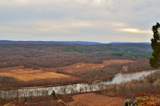
A break in the trees provided nice views of the Delaware River below, and based on the name, I assume we could see into Pennsylvania, New Jersey, and New York. After a brief stop, we followed the trail back to the parking area. We had planned on stopping at Dingmans Falls next, but the road was closed. Winter in Pennsylvania means a lot is closed. We had really wanted to visit Ricketts Glen, but that had closed a few weeks before. Although privately-owned, nearby Bushkill Falls was still open, so that was our next destination. After arriving, we paid admission to the falls...at $12.50 per person, it was a little expensive. But we really wanted to get this waterfall, and there are actually quite a few in a short walk around the property. A big winter storm was in the forecast, so we were fortunate to make it before they closed for the season. Talking to the lady who sold us our tickets, she suspected that this would be the last day the falls were open. And with few other visitors, we mostly had the area to ourselves. We hiked along the Red Trail, the longest trail in the park. At only two miles, it wouldn't be much of a challenge, but we would hit all the waterfalls. Starting out we turned right, following the trail upstream along Little Bushkill Creek. Shortly, we reached the first waterfall - Pennell Falls, a small cascading waterfall.


We crossed the bridge over the creek below the falls and continued through the woods to the next intersection. Continuing straight, we stayed on the Red Trail, crossing Pond Run Creek and then heading downstream along a series of steps and wooden overlooks. There are three waterfalls right in a row here.


First was Upper Bridesmaid’s Falls, a two-tiered waterfall partially tucked away in the gorge. Bridal Veil Falls, the largest of the three, is a nice cascading waterfall, 28 feet high.


And right below that is Lower Bridesmaid’s Falls, probably the smallest of the three, but very pretty with a freefall followed by a cascade.


After stopping for some pictures at each we continued on the trail and crossed back over the creek at the confluence of Little Bushkill and Pond Run Creeks.


We hiked up the gorge passing Lower Gorge Falls and then made it to the base of the main Falls.


Bushkill Falls is a nearly 100-foot cascading waterfall and was quite impressive.


We got some pictures from the bridge over the base of the falls and then climbed up to get some from the top.


We finished up our hike through the Upper Canyon above the main falls and then headed back to the car. It was past lunch time and we only had a few more hours of daylight left, so we wanted to make it count. So we headed to George W. Childs Park, once a Pennsylvania State Park, but now a recreation area in the water gap. We parked here and had a picnic lunch, then headed out for a hike. There are three waterfalls along Dingmans creek in this area. From the parking area, we hiked down the trail and passed the top of Factory Falls, though we couldn’t see much from here.


Then, we came out near the top of Fulmer Falls. I climbed out on a rock outcrop close to the top of the falls, though we couldn’t see the whole thing.


We found a bridge to cross to the other side of the creek, but the only place to see all of Fulmer Falls was along the trail through a break in the trees.


Scrambling down to the base would be rather tricky and we didn’t have a lot of time, so I didn’t try anything crazy.


We did head upstream a bit for a better view of Factory Falls, which was a pretty cool waterfall.


Then we continued downstream to see Deer Leap Falls, the last one in the area. At this one, the water flows through a narrow chute, crashing down on a rock at the base.


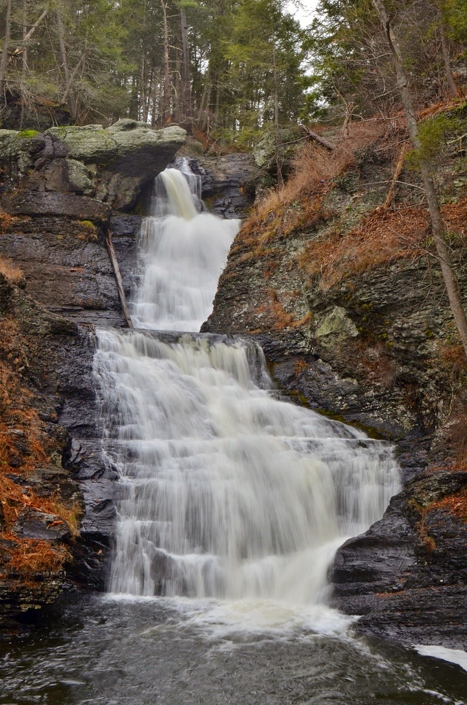
This was the last waterfall in the area, but I had a plan for one more. We were on Dingmans Creek just a mile or so upstream of Dingmans Falls. The road to the falls was closed, but perhaps we could just follow the creek downstream. We crossed the creek once again on the bridge below Deer Leap Falls and found a faint path following the creek downstream. We got on this and hiked about a half-mile to cross Milford Road and then continued downstream. After the road crossing, the path was very easy to follow and in about another mile, we came out at the top of Dingmans Falls. At about 130 feet high, this is a tall waterfall. And that meant a lot of stairs to go down to reach the base. But the waterfall was spectacular, my favorite of our trip.


And apparently we weren’t the only who got creative in finding a way in as we saw one other couple at the falls. We climbed down to the base and got some pictures then continued on just a short ways to Silverthread Falls. This waterfall is about 80 feet high and very thin, plunging down in two tiers through a narrow crack in the shale.


After we got some pictures, we started making our way back. Climbing the stairs to the top of Dingmans Falls was the most difficult part and once back on the unofficial trail, the going was pretty easy. We made it back to the car and then started making the drive back to Doylestown.

Monday, November 24, 2014

Ringing Rocks

Monday morning, we had breakfast with Sandy’s dad again and then packed our stuff up and started making our way to Pennsylvania. We would be spending Thanksgiving with her other aunt and uncle in Doylestown, north of Philadelphia. Along the way, we stopped at the mall in King of Prussia, so Sandy could get in a little holiday shopping and take advantage of Pennsylvania’s lack of sales tax on clothing. We had lunch at Rock Bottom, a brewery and restaurant, where I tried their Ichabod’s Pumpkin Ale, complete with a cinnamon-and-sugar-rimmed glass. It was yummy! Leaving King of Prussia, we headed towards Doylestown, but stopped for another waterfall just outside of town. We headed north of Doylestown on PA-611 and headed to Ringing Rocks County Park. Not only is there a waterfall at this park, but there are also musical rocks! After parking, we hiked down the short trail past the rock field to Ringing Rocks Falls.


We came out at the top of the waterfall and had to scramble down to the base for good views of the waterfall. The water flows over a rock face and falls about 18 feet in two streams. It’s not a particularly exceptional waterfall, but rather unexpected in the rolling hills of Bucks County.


After some pictures, we headed back on the trail and then headed out to Ringing Rocks. Having planned for an excursion here, I remembered to pack a hammer to bring with us. There were several other people here, so we climbed out to an unoccupied area and began hitting the rocks.


Due to an unusual resonance of the rocks, they ring like a bell when hit with a hammer. We spent a while here, banging on the rocks and making “music”. It was a really unique experience. When we were finished, we headed to Doylestown and unpacked. Sandy’s uncle told us people had been banging those rocks since he was a child.

Sunday, November 23, 2014

Rocks and Wolves

Sunday morning, we woke up and went to breakfast with Sandy’s dad. After breakfast, we started heading north. There was a detour on MD-24 at Rocks State Park and we had to go a little out of the way. We followed MD-23 to MD-165 and took the short gravel drive to the Falling Branch area of the park. We arrived just before 10 and had to wait a couple minutes for the gates to open. Once the park opened, we headed out on the short hike to Kilgore Falls, the second highest free-falling waterfall in the state of Maryland.


At 18 feet, it’s not a particularly high waterfall, but very pretty with three distinct streams flowing over the rock face. As we approached the waterfall, we realized that we would have to rock hop across Falling Branch to get a good view of the waterfall. Not expecting a challenging hike, neither of us had worn hiking boots or brought trekking poles. But we found a couple of sticks on the ground to act as poles and made it across and headed up to near the base of the waterfall. It was a chilly morning and there was ice around the waterfall, making the waterfall that much more scenic.


It’s my understanding that this is a popular waterfall and swimming hole in the warmer months, but early on a November morning, we had the place to ourselves. We didn’t linger long, however, as we had to get up to Pennsylvania. We drove for a little over an hour through Lancaster to the Wolf Sanctuary of PA. Sandy’s mom had suggested we visit while we were in the area. We arrived right at 12, purchased our tickets, and started the tour. There were a lot of people here and our tour group was fairly large, but our tour guide, Denny, did a great job and the tours still felt personal. For about 2 hours, Denny took us around to meet the different packs.


The first pack we visited was Merlin’s pack, including him, Keisha, and his son Tioga. Merlin was the alpha, but he wasn't interested in food or visitors today. Tioga, was very interested in food, however. If Merlin had been interested, Tioga would have had to wait for his treats. At one point, Tioga peed in his enclosure. Almost immediately, Merlin jumped up, ran across the enclosure, peed over Tioga’s spot, then ran back and went back to sleep! It was amazing how he showed his dominance.


Later, we visited the large pack with about a dozen wolves, some who were hungry and excited for treats, others who didn’t bother getting up.


Sandy’s favorite wolf was Winston, an older wolf who lived in this pack. Denny said he had to specially give Winston his food as the others sometimes bullied him.


At one point on the tour, Denny made howling sounds. Soon, one wolf joined in howling, then a couple more, and pretty soon, just about all the wolves were howling! It was a beautiful sound.


We had a really good time on this tour and it was great to see how these people were taking care of these beautiful animals.


Our tour finished up a little after 2 and we started heading back to Maryland. But before we headed back to her relatives’ house, we stopped back at Rocks State Park and went to the Rock Ridge Picnic Area. It was getting late and we didn’t have a lot of time, so we quickly hiked the short red trail to King and Queen Seat.


This huge rock outcrop above Deer Creek provided great views in the waning daylight. It’s believed to have once been a ceremonial meeting place for the Susquehannock people. We climbed around on the rocks for a bit and got some pictures of the lovely views over the Deer Creek valley and then headed back to the in-laws.


We had dinner with her family again and then started getting our stuff packed up in preparation to head to Pennsylvania.

Saturday, November 22, 2014

Great Falls and Billy Goat Trail

For the Thanksgiving holiday, Sandy and I had to head up north to visit her relatives. So of course, we had to get some waterfalls on the way! We would first be heading to Forest Hill, Maryland to visit her aunt and uncle. We left early Saturday morning and started heading north on I-85 and I-95 through Virginia. Near Washington, DC, we got on I-495 and took Clara Barton Parkway to the Great Falls Tavern area of Chesapeake & Ohio Canal National Historic Park. After paying admission and parking, we headed out past the old tavern along the towpath following the canal. After passing the Mercer canal boat that was propped up in the canal, we turned right to head towards Great Falls. The Olmsted Island Bridges are a series of wooden bridges and boardwalks that extend from the towpath to the far end of Olmsted Island.


The Potomac River is turbulent here, tumbling down cascades and rocky falls as it flows past the island. We followed the bridges out to the far end of Olmsted Island at a viewing platform for Great Falls.


Great Falls is a surprisingly large waterfall on the Potomac River at the fall line - where the Piedmont transitions to the coastal plain. Even more surprising is its close proximity to Washington, DC, only about 15 miles. The falls consists of a series of cascades totaling about 76 feet in height with a huge volume of water.


We had a nice panoramic view of the falls from the overlook, but it was from a distance. Visitors are not allowed off the wooden viewing platform for a closer look. It was also quite crowded, so we got a few pictures and then headed back. We had forgotten to pick up lunch, so we quickly headed back to the car and got some snacks, then headed back down the towpath.


Right before the stop gate, we turned to get on Billy Goat Trail A, which heads out onto the rocky Bear Island. This trail is a lot of fun as it involves much scrambling over rocks and boulders and even a section where we would have to scale a cliff. The trail starts off moderate - rocky ground, but mostly flat and not too hard to follow.


There were a couple nice spots with great views of Mather Gorge and Potomac River and the Virginia park on the other side.


About half-way, we got to the cliff. The main path up and down goes through a crevasse in the cliff to provide some footing. There were a bunch of people coming down and we didn’t really want to wait, so we just climbed up along the side to make it to the top. We continued along, eventually descending down to river level at Purplehorse Beach.


I climbed out onto the rocks for some more pictures of the river, but there was a good bit of ice out here and very slippery. Then, we finished up the trail, arriving back at the towpath about a mile down from where we had gotten off of it near Widewater.


As we started hiking back, we stopped at a little pond to see a beaver walking across.


The pond was partially frozen and the beaver was making his way across, slipping and sliding as he went. At one point, the thin ice broke and he splashed into the water, then made his way to the edge. He was poking around looking for food and eventually climbed up to the towpath to nibble on vegetation right alongside the trail.


We got some pictures and video of this beaver, who didn’t seem to be afraid of humans at all. Then we finished walking back up the towpath to the tavern and returned to our car. This is a great little park, right outside Washington, DC, and I’m glad we made it here. We’ll have to come back to explore more again some time soon when we have more time. From here, we finished the drive up to Forest Hill and had dinner with Sandy’s family before going to bed early.