Tuesday, April 5, 2016

Tennessee State Parks Waterfalls

Tuesday, we headed back to the Cumberland Plateau region, heading towards Cookeville. North of Cookeville, we headed to Cummins Falls State Park. This small state park is centered around the 75-foot waterfall on Blackburn Fork River. From the parking lot, we first hiked the short Fall Overlook Trail to the overlook with a decent view of the falls, but the best views would be from the base.


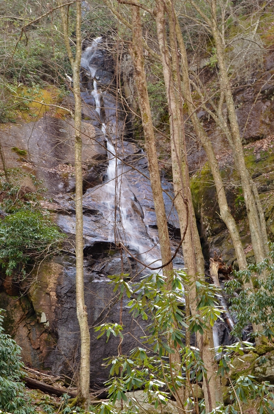
We then followed Blackburn Fork River Trail down to river level and then started following the river upstream towards the falls. About half-way, we could see a small tributary waterfall tumbling down from the other side of the river.


After this point, there was no more trail and we couldn’t find a way across. It was particularly cold and the water level was up and there was no easy way across. We walked around searching for a decent way across but had no luck. Since we had many more waterfalls for the day, we decided to just give up and head back. In hindsight, we should have made more of an effort and gotten across.


At least we saw a number of pretty wildflowers on the hike back up out of the gorge, including trillium and Dutchman's breeches.


Originally, our next waterfall was Burgess Falls. Unfortunately, the park closed the trail to the main waterfall due to storm damage, so we decided to go to Rock Island State Park instead. We stopped first at Great Falls just beyond the dam.


A short trail leads down to river level for good views of this huge river-wide waterfall. Unfortunately, when we arrived, a park ranger informed us that the trail was closed due to high water. So we could only get some photos from the overlook. From here, we could see one section of Great Falls as well as Twin Falls in the distance.


We drove a little further back and found another overlook next to the Great Falls Cotton Mill. More of Great Falls was visible from here and we wanted to see as much as possible with the trail to the base close.


After a couple pictures, we continued to the other side of the river to the Twin Falls Observation area. Although the Upstream Trail was closed, the Downstream Trail was not so we could get some good views of Twin Falls. The best view was from an open spot just upstream of the waterfall.


We went a little further and climbed out on the rocks, but the waterfall is just too big. It's really an interesting waterfall. When the Great Falls Dam was constructed near the confluence of Caney Fork and Collins River, the water level of Collins River rose. This extra water flooded an underground cavern, which ultimately exits through Twin Falls. Although it's a man-made waterfall, it was very impressive. Next we headed to Fall Creek Falls State Park. Our first stop was at the Nature Center near Cane Creek Falls. After getting our stuff together we headed to the suspension bridge over Cane Creek and then down to the Cane Creek Cascades.


This nice 40-foot waterfall is basically the upper portion Cane Creek Falls. Then we headed to the overlook to see the Cane Creek and Rockhouse Falls.


There was enough spray that a double rainbow was visible in the pool below. To the right, we could see Rockhouse Falls, a smaller but even higher free-falling waterfall.


We planned to go to the base, but the Cable Trail was closed and yet again, we couldn’t make it down. We went to the other overlook for the falls, but the view was not very good. Trees blocked seeing much of the waterfall. So we continued on to Fall Creek Falls. The trail to the base of this one was open! We first stopped at the overlook which provided a very nice view of Fall Creek Falls and the adjacent Coon Creek Falls.


Fall Creek Falls is below the dam, so even in high water the flow wasn’t too great. But these waterfalls are among the highest free-falling waterfalls in the eastern US. I couldn’t help but think that the only waterfall with the trail to the base open was the one with the best overlook view. We were definitely regretting not getting to the base of Cummins Falls this morning. After some pictures from the overlook, we headed down into the gorge on the Base of Falls Trail.


It was a steep trail, leading down into the gorge via a couple switchbacks. Then, we headed upstream along Fall Creek past some huge rock cliffs.


At the base, I played around and climbed on the rocks to get pictures of the waterfalls from different angles.


Then we started slowly making our way back up. From the parking area, we continued on the one-way scenic loop, stopping at a couple overlooks for views of the Cane Creek gorge.


We also stopped at Millikan's Overlook with a view of the Piney Creek Gorge and confluence with Caney Creek.


Then we made one last stop to see Piney Creek Falls. The overlook isn’t great and the views are somewhat blocked by trees, but it’s a real short hike.


After a couple pictures, we started making our way back to Cleveland. We stopped and picked up a pizza for dinner on the way.

Monday, April 4, 2016

Virgin Falls

Monday morning, we were heading north back to the Cumberland Plateau area for a great day hike. We drove towards Crossville and headed into Scott's Gulf to the Virgin Falls State Natural Area. It’s a good long hike, so we planned to spend the entire day here. After getting our stuff together, we set off on the trail. The first mile or so is pretty easy and flat, following Big Branch downstream. In just over a mile, right after crossing the creek, we came to our first waterfall of the day – Big Branch Falls.


This is the smallest waterfall in the area with a drop of about 20 feet. It's also the only "normal" waterfall with the water continuing to flow above ground after the waterfall. We stopped for a couple of pictures and then continued on down to Big Laurel Creek and the cable crossing. Even in fairly high water levels, the crossing was pretty easy and I don't think the cable was necessary. From here, the trail became more steep as we headed downstream along Big Laurel Creek. It was all downhill, so not so tough going down, but it would be more strenuous on the way back out. We saw a group of backpackers making their way out and we knew it would be a tough hike back up. We continued down the creek until came to Big Laurel Falls.


This amazing waterfall drops 40 feet over a cliff, then flows backwards into a rockhouse behind the falls and disappears! The water flows into the ground and presumably flows underground until it reaches Caney Fork River.


We walked around for a while getting pictures of the waterfall from different angles and checking out the cave behind the falls.


A sign at the trailhead indicated that all the caves were closed to reduce the risk to bats, so we didn't explore in the cave itself. Then we continued on the trail, following the now-underground creek downstream, though there was no creek to see - just a depression in the ground. As we got closer to Caney Fork River, we reached the Loop Trail and turned right and headed towards Sheep Cave. Like Big Laurel Falls, this waterfall drains into a sinkhole and disappears.


But it also comes out of a cave! Unfortunately, there were too many trees and vegetation to get a picture of the entire thing. We climbed up to Sheep Cave and had a snack here, watching the water flow out of the cave and then over the waterfall. I found a ledge to climb out on and get a picture of the upper section of the falls.


Then we headed back and continued on towards Virgin Falls. Looking down, we could see where the underground creeks likely were located, draining the water from the waterfalls. Continuing on a short ways, we came to Virgin Falls. The water for Virgin Falls originates from a cave, drops 110 feet and falls into a sinkhole, disappearing from view.


This is truly a spectacular waterfall! We got some pictures from the midpoint and walked around a bit.


I found a nice patch of beautiful trout lilies blooming near the falls.


Then we headed up to the top to see the cave. Located about 40 feet from the brink, all of the water came out of a small cave in the side of the mountain.


Where that water came from, I have no idea. A cool breeze was emanating from the cave and felt like air conditioning. We got some pictures from up here, then continued back down to the base and started making our way back. On the way, we made a detour to Caney Fork River. The river was very pretty with a number of small rapids.


There appeared to be a ford at this point, but the water level was way too high to cross. We also saw lots of pretty wildflowers blooming along the shore.


After a snack break, we started making our way back. We stopped again at Big Laurel Falls as a rainbow was now visible.


Continuing up the trail past the waterfall, there were a number of nice cascades that we had passed on the way down.


We made a couple quick stops to scamble down and see some of these nice cascades. Most of them had great swim holes, but it was way too cold to think about swimming today. We made another quick stop at Big Branch Falls as the lighting was better than it had been in the morning.


Then we finished our hike back to the car. I spotted some beautiful eastern redbud blooming right by the parking area.


We headed into Crossville for dinner at Cancun Mexican Restaurant and then drove back to our hotel in Cleveland.

Sunday, April 3, 2016

Cumberland Plateau Waterfalls

Sunday morning, we checked out of the hotel early and had breakfast at IHOP. Then we headed towards the Cumberland Plateau area. We got on I-40 west towards Nashville, getting off on US-70 near Crab Orchard. Our first waterfall for the day was Ozone Falls. This is a beautiful 100-foot free fall with an easy hike.


Being a weekend, we wanted to get there early before the crowds. We arrived around 9 (central time) and were the first people here. From the parking area, we headed down to the waterfall, passing the tall cliffs and the Gamblers’ Den, a location for illicit gambling in the past.


Past this we came to a viewpoint at about the middle of the waterfall. I usually like to see waterfalls from the base, but this one had a great viewpoint from the middle.


I think the waterfall actually looked bigger from the middle than from the base. We then climbed down to the base to get some pictures from this perspective as well as the cascades below the main drop.


Then we headed back to the car and continued on to the next waterfall. We got on TN-68 towards Spring City, turning onto Firetower Road just past Grandview to park at the Piney Falls State Natural Area. There are two waterfalls here – the upper and lower falls on Piney Creek. We started hiking down the trail and turned right at the split to head towards the top of Upper Piney Falls. Under normal conditions, it’s possible to cross the creek above the falls and work down to the base. But the water was way too high today. So we backtracked and went first to Lower Piney Falls. The trail comes out at the top of the waterfall, but there isn’t a good view from here.


The tall cliffs prevented getting any further down. As we were heading back, I saw some people coming from a side path. Thinking that might lead to the base, we turned and tried to follow the path, but found no way to get down to creek level.


Finally giving up, we headed to the base of Upper Piney Falls. Just before getting there, I saw the couple from before and asked if they had figured out how to get to the base, but they had no more luck than we did.


I got some pictures from the base of Upper Piney Falls and tried to go behind the falls, but they spray was so intense, I turned back.


On the way back, we tried one more time to try to get to the base of Lower Piney Falls, but couldn’t find any reasonable path. So we headed back to the car and continued to Shut In Gap Road to Stinging Fork Falls State Natural Area. The first part of the hike was through new-growth forest and eventually started heading down to the creek into a more natural area. As we got to near the top of the falls, we saw some people scrambling down to the base and followed. Getting back up would be tricky, but it turns out we had gotten off the trail and following the trail would be a much easier hike back up. Stinging Fork Falls is a really beautiful waterfall with a great swimming hole at the base.


It was way too cold for swimming today and unfortunately, the sun was shining right on the waterfall. I tried to get a couple pictures and then we followed the trail back. There were some nice cascades along the creek downstream from the falls and stairs provided a much easier path to the top.


On the way back, we swung by the overlook, but the views were mostly obscured by trees. The creek was not visible below (though it was easily heard), though the surrounding cliffs were very pretty. We then headed back to the car and continued up the road a short ways and turned on Walden Mountain Road to the Cumberland Trail parking. Right at the parking area, a large number of tiger swallowtail butterflies were puddling on the ground.


We started hiking along the Cumberland Trail following Duskin Creek downstream. There were lots of scenic little cascades along the creek.


In a mile or so, we made it to White Pine Cascades. It’s a really scenic cascading waterfall on the creek with an inviting swim hole at the base. Unfortunately, the sun was shining directly on it, ruining any chance for a decent picture.


Without a cloud in the sky, there wasn’t much chance the situation would change any time soon, so we started hiking back. We stopped at several of the little cascades along the way.


Back at the car, we headed back to paved roads and drove towards Cleveland. We checked into our hotel, Holiday Inn Express, and then went across the street for dinner at Fulin’s Asian Cuisine.

Saturday, April 2, 2016

Hampton Area Waterfalls

The first week of April, Sandy and I headed to Tennessee for a week of waterfalls in the Cumberland Plateau region. We left before 6 on Saturday morning and headed west. In Winston-Salem, we took US-421 north through Boone. After turning on US-321 past Boone, we made our first stop for a couple quick waterfalls in North Carolina before crossing the state line. Our first stop was Laurel Creek Falls, also called Trash Can Falls. We parked along US-321 near where Laurel Creek drains into Watauga River, crossed the street and followed a short path up along Laurel Creek. Laurel Creek Falls is a 15-foot waterfall in two streams over some large boulders.


There’s a nice swim hole at the base and then a series of cascades and slides leading back down to the road. I got some pictures of the main drop and then scrambled down to see the lower part. It's a nice waterfall, despite the nickname.


Then we backtracked to the car and drove less than a quarter-mile further up US-321 to another pull out. A very steep scramble path led down from the road to the Watauga River. Watauga Falls is here, but it’s a stretch calling it a waterfall – more of a rapid.


But it was marked on the topo map and we were right here, so we made a quick stop. After this, we returned to the car and headed into Tennessee. A few miles past the state line, we turned left on Poga Road and went three miles or so. We made a right turn on Clawson Road and then right on Dark Ridge Road and drove a short ways to a parking area on the left after it turned to gravel. Our next waterfall was Twisting Falls, also called Compression Falls, on Elk River. Once we got our stuff together, we started hiking down the path to the powerlines and then the very steep hike down to the river. I got almost all the way to the bottom and realized I forgot my camera, so ran back up to get it. It was quite a strenuous trip back up. After retrieving the camera, I headed back down and followed Elk River a short ways upstream to the waterfall.


From here, we could only see the lowest 30-foot drop of the waterfall as well as a second stream flowing down in parallel. The river level was way up and everything was soaked from spray. I got as close as possible to get a picture of the falls, but could only see the main drop. So I headed back a ways to get a picture of both streams.


Then I went a little further back to get a shot of the falls from a distance with the river in the foreground.


Overall, this is a very nice waterfall and extremely popular swim hole in the summer. Then, we had to make the steep climb up, a second time for me. Back at the car, we continued back to US-321 and continued towards Hampton. We pulled off at the parking area long US-321 at the trailhead for Laurel Fork Falls. We got our stuff together and started hiking down the blue-blazed Hampton Blueline/Laurel Falls Trail (#501). The trail headed up to a ridgeline and followed Laurel Fork upstream, soon entering the Pond Mountain Wilderness. Shortly, we went right at the fork to follow the low-water route and hike along the creek through a beautiful gorge area. High rocky cliffs rose along the bubbling creek.


About a mile into the hike, we came to the Appalachian Trail (#1) and followed this southbound by bearing right at the fork. There were a few sections with some elevation gain, but overall a pretty easy section of trail. As we approached the waterfall, we had to scramble over some rocks through another beautiful gorge section and then made it to the base of the Laurel Fork Falls.


This is a beautiful 60-foot waterfall that is nearly as wide as it is tall. We took a break down here and had a snack, enjoying the view of the waterfall. I got some pictures from different angles and then we started making our way back.


The hike back along the AT and Blueline Trail was just as scenic on the way out as it was on the way in.


I think there's a shorter way to get to the waterfall coming the other way on the AT, but this was such a nice hike, there was no reason to shorten it. We drove just a short ways further on US-321 and then turned onto Dennis Cove Road. This road is paved, but very steep and windy. It was about 4.5 miles to the pull-off for Coon Den Falls. The parking spot is very small – only big enough for one car, and we initially passed it and had to turn around. Only a metal stake indicated the trail started here. It’s only a half-mile to the waterfall, but it’s uphill the entire way, gaining over 400 vertical feet. We followed the trail up along Coon Den Branch to the waterfall for a couple pictures.


It’s a fairly tall waterfall, with the water sliding down through a narrow crack in the rock. There was too much vegetation in the way to get a good picture though.


So we headed back down to the car and drove about a quarter-mile further to park outside the closed Dennis Cove Campground. We were going to hike to Dennis Cove Falls, which is about a mile up Laurel Fork Trail from here. There are a couple fords on the way to the waterfall, so we hiked in water shoes. In about a half-mile, we came to the first crossing. There was a cable strung across, but the water was so deep and fast-moving, it didn’t look safe. We decided to turn around and give up. From here, we drove into Johnson City and had dinner at Firehouse Restaurant. They had some pretty good barbeque. Then we checked into our hotel for the evening – the Red Roof Inn. It was a cheap option since we were only staying one night before heading further into Tennessee.