
There’s a nice swim hole at the base and then a series of cascades and slides leading back down to the road. I got some pictures of the main drop and then scrambled down to see the lower part. It's a nice waterfall, despite the nickname.

Then we backtracked to the car and drove less than a quarter-mile further up US-321 to another pull out. A very steep scramble path led down from the road to the Watauga River. Watauga Falls is here, but it’s a stretch calling it a waterfall – more of a rapid.

But it was marked on the topo map and we were right here, so we made a quick stop. After this, we returned to the car and headed into Tennessee. A few miles past the state line, we turned left on Poga Road and went three miles or so. We made a right turn on Clawson Road and then right on Dark Ridge Road and drove a short ways to a parking area on the left after it turned to gravel. Our next waterfall was Twisting Falls, also called Compression Falls, on Elk River. Once we got our stuff together, we started hiking down the path to the powerlines and then the very steep hike down to the river. I got almost all the way to the bottom and realized I forgot my camera, so ran back up to get it. It was quite a strenuous trip back up. After retrieving the camera, I headed back down and followed Elk River a short ways upstream to the waterfall.

From here, we could only see the lowest 30-foot drop of the waterfall as well as a second stream flowing down in parallel. The river level was way up and everything was soaked from spray. I got as close as possible to get a picture of the falls, but could only see the main drop. So I headed back a ways to get a picture of both streams.

Then I went a little further back to get a shot of the falls from a distance with the river in the foreground.

Overall, this is a very nice waterfall and extremely popular swim hole in the summer. Then, we had to make the steep climb up, a second time for me. Back at the car, we continued back to US-321 and continued towards Hampton. We pulled off at the parking area long US-321 at the trailhead for Laurel Fork Falls. We got our stuff together and started hiking down the blue-blazed Hampton Blueline/Laurel Falls Trail (#501). The trail headed up to a ridgeline and followed Laurel Fork upstream, soon entering the Pond Mountain Wilderness. Shortly, we went right at the fork to follow the low-water route and hike along the creek through a beautiful gorge area. High rocky cliffs rose along the bubbling creek.

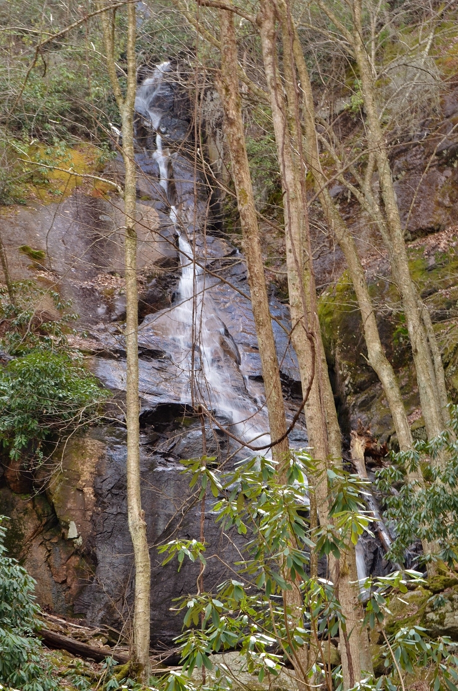
About a mile into the hike, we came to the Appalachian Trail (#1) and followed this southbound by bearing right at the fork. There were a few sections with some elevation gain, but overall a pretty easy section of trail. As we approached the waterfall, we had to scramble over some rocks through another beautiful gorge section and then made it to the base of the Laurel Fork Falls.

This is a beautiful 60-foot waterfall that is nearly as wide as it is tall. We took a break down here and had a snack, enjoying the view of the waterfall. I got some pictures from different angles and then we started making our way back.

The hike back along the AT and Blueline Trail was just as scenic on the way out as it was on the way in.

I think there's a shorter way to get to the waterfall coming the other way on the AT, but this was such a nice hike, there was no reason to shorten it. We drove just a short ways further on US-321 and then turned onto Dennis Cove Road. This road is paved, but very steep and windy. It was about 4.5 miles to the pull-off for Coon Den Falls. The parking spot is very small – only big enough for one car, and we initially passed it and had to turn around. Only a metal stake indicated the trail started here. It’s only a half-mile to the waterfall, but it’s uphill the entire way, gaining over 400 vertical feet. We followed the trail up along Coon Den Branch to the waterfall for a couple pictures.

It’s a fairly tall waterfall, with the water sliding down through a narrow crack in the rock. There was too much vegetation in the way to get a good picture though.
So we headed back down to the car and drove about a quarter-mile further to park outside the closed Dennis Cove Campground. We were going to hike to Dennis Cove Falls, which is about a mile up Laurel Fork Trail from here. There are a couple fords on the way to the waterfall, so we hiked in water shoes. In about a half-mile, we came to the first crossing. There was a cable strung across, but the water was so deep and fast-moving, it didn’t look safe. We decided to turn around and give up. From here, we drove into Johnson City and had dinner at Firehouse Restaurant. They had some pretty good barbeque. Then we checked into our hotel for the evening – the Red Roof Inn. It was a cheap option since we were only staying one night before heading further into Tennessee.
No comments:
Post a Comment