Upper Buckeye Creek Falls (Beech Mountain)

Upper Buckeye Creek Falls is an 8-foot waterfall on its namesake in Avery and Watauga County, North Carolina.  The waterfall is located along the Beech Mountain Trails.

Hike Length: 5.8 miles
Estimated Time: 2 to 3 hours
Difficulty: Moderate
Location: Beech Mountain Trails
Trail Users: Hiking only
Dogs: Yes
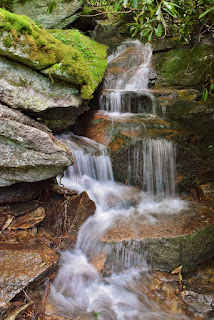
Features: Waterfalls (1)
Crowds: Moderate
Warnings: The rocks around waterfalls are slippery.
Trailhead GPS: 36.21999,-81.90407 
Waterfall GPS: 36.20068,-81.89392

Directions:


From Boone, head west on US-321 North for about 15 miles and turn left onto Buckeye Road. Continue on Buckeye Road for about 3.5 miles and turn left on Buckeye Creek Road. Go about 2.5 miles on Buckeye Creek Road and turn left on Pine Ridge Road. The Buckeye Recreation Center will be on the left in 0.5 miles..

Map:


Hike Description:


From the recreation center, turn left on Pine Ridge Road and walk a short ways to the trailhead for Grassy Gap Trail. This trail follows its namesake creek upstream on a natural surface trail for a mile or so, crossing a couple old roads. Eventually, the trail turns right and follows an old road for a while with Red Fox Trail joining up. Where the two trails split, go right to stay on Red Fox Trail and follow to the end at Pinnacle Ridge Road. Turn left and follow the road a short ways to Woodland Road on the right, which is also Smoketree Trail. The trail heads down and then up with two switchbacks. At the second, the trail follows Mill Pond Lane a short distance, then bears left onto Smoketree Road. In about a half-mile, the trail crosses Buckeye Creek and the waterfall is immediately upstream of the road. It's a small waterfall, but photogenic in high water.


There may be a shorter way to get here, but Beech Mountain is rather confusing to navigate and this is how I got here.

Blog Entries:


External Links:


Beech Mountain website: https://beechmtn.com/hiking/

No comments:

Post a Comment