
Directions:
Beech Mountain is located west of Boone in the northwest corner of North Carolina. From Boone, follow NC-105 south for 13 miles and turn right on NC-184. Go 4.2 miles, turn left and then right to stay on NC-184. NC-184 continues up to and ends in Beech Mountain. The roads in Beech Mountain are rather confusing and its recommended to pick up a map at the visitor center.
Map:
Trails:
There are 28 miles of trails throughout Beech Mountain.
Buckeye Lake Loop:
Length: 1.6 miles
Blaze: Green
Difficulty: Moderate
Buckeye Lake Loop is a 1.6 mile loop around the lake. The trail can be accessed from the Buckeye Recreation Center or Shane Park. It runs concurrently with Falls Trail from the dam to the recreation center. There are nice views of the lake from the trail.

Falls Trail:
Length: 1 mile
Blaze: Red
Difficulty: Moderate
Falls Trail is a 1-mile loop trail that starts and ends at the Buckeye Recreation Center. From just beyond the playground, the trail descends to a split where the loop forms. Going right, the trail heads down towards Grassy Gap Creek near the confluence with Buckeye Creek. Buckeye Creek Falls, a nice 25-foot waterfall, is just upstream of the confluence. A wooden footbridge provide passage across the creek and then the trail follows Buckeye Creek upstream passing some scenic cascades. At the dam, the trail runs concurrently with Buckeye Lake Loop to finish the loop.

Grassy Gap Creek Trail:
Length: 2 miles
Blaze: Pink
Difficulty: Easy to Moderate
Grassy Gap Trail is a 2-mile trail that leads from Pine Ridge Road near the Buckeye Recreation Center to Hawthorne, following its namesake upstream. The lower trailhead is along Pine Ridge Road just northeast of the Buckeye Recreation Center. The trail crosses Sassafras Road/Trail in about a half-mile and then Raccoon Road shortly after. A detour requires taking Raccoon Road and Red Fox back. Along Arrowhead Road, the trail splits and heads up to follow Grassy Gap Creek up to Hawthorne Road, the eastern terminus.
Lower Pond Creek Trail:
Length: 0.6 miles
Blaze: Purple
Difficulty: Moderate to Strenuous
Lower Pond Creek Trail leads from Lake Coffey to Locust Ridge Road, following Pond Creek downstream. The trail is rocky and rugged and more challenging than other trails in Beech Mountain. Pond Creek is almost continuous cascades and small drops along this section. She Falls Falls is located about half way down the trail.

Overlook Trail:
Length: 0.4 miles
Blaze: Yellow
Difficulty: Moderate
Overlook Trail is one of the newest trails in Beech Mountain. The trail leads from the Parkway Overlook down to Perry Park on Tamarack Road. The overlook provides nice views of the surrounding countryside and there is a small waterfall at Perry Park.
Red Fox/Arrowhead Trail:
Length: 1.5 miles
Blaze: Red
Difficulty: Easy to Moderate
Red Fox/Arrowhead Trail follows gravel roads, beginning at Red Fox Lane along Pinnacle Ridge Road. In under a half-mile, Grassy Gap Creek Trail joins and the two run together for a quarter mile and then split, with this trail going right and following Arrowhead Road back out to Pinnacle Ridge Road.
Sassafras Trail:
Length: 0.9 miles
Blaze: Yellow
Difficulty: Easy
Sassafras Trail follows a gravel road from Pinnacle Ridge Road to Jackpine Road. It crosses Grassy Gap Trail near Jackpine Road.
Smoketree Trail:
Length: 1.8 miles
Blaze: Red
Difficulty: Easy to Moderate
Smoketree Trail follows gravel roads beginning at Woodland Road along Pinnacle Ridge Road. The trail descends to Bear Branch then heads up. After the second switchback, the trail follows Mill Pond Road for a short ways then bearing left, it follows Smoketree Road. Where the trail crosses Buckeye Creek, Upper Buckeye Creek Falls is immediately upstream. The trail continues on, ending at Beech Mountain Parkway.

Waterfalls:
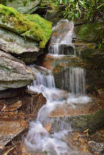
Buckeye Creek Falls:
Buckeye Creek Falls is a 25-foot waterfall accessed from Falls Trail at the Buckeye Recreation Center.

Buckeye Creek Upper Falls:
Upper Buckeye Creek Falls is an 8-foot waterfall on the upper reaches of Buckeye Creek.
Perry Park Waterfall:
Perry Park Waterfall is a small roadside waterfall on Pond Creek at Perry Park.

She Falls Falls:
She Falls Falls is a 20-foot waterfall on Pond Creek.

Wildlife:
Mountain laurel (Kalmia latifolia)

Hemlock Varnish Shelf (Ganoderma tsugae) is a polypore mushroom that typically grows on hemlock trees.

Blog Entries:
17-Jun-2023: Beech Mountain Hike
09-Jun-2018: Beech Mountain Waterfalls
External Links:
Beech Mountain website: https://beechmtn.com/hiking/
No comments:
Post a Comment