
Directions:
Peaks of Otter is located about ten miles northwest of Bedford. From Bedford, take VA-43 north for about ten miles to the Blue Ridge Parkway. The Peaks of Otter Visitor Center is right here at the intersection. From I-81, take exit 162 for Buchanan and turn on US-11 north. Go about 2.5 miles and turn right on State Road 625. In 3.5 miles, turn right on VA-43 south. Go about 3 miles and turn left on the Blue Ridge Parkway and drive 5 miles to the Peaks of Otter Visitor Center.
Map:
Trails:
Abbott Lake Trail:
Length: 1 mile (loop)
Difficulty: Easy
Abbott Lake Trail is a 1-mile accessible loop around the lake.

Fallingwater Cascades Trail:
Length: 1.6 miles (loop)
Difficulty: Moderate
Fallingwater Cascades Trail is a 1.6-mile loop that provides access to Fallingwater Cascades. The trail can be accessed from two pulloffs on the Blue Ridge Parkway between mile posts 83 and 84 - Flat Top Parking Area and Fallingwater Parking Area. From Flat Top Parking Area, cross the parkway and almost immediately come to a split. Bear right and you will pass the other parking area shortly. The trail then heads down towards Fallingwater Creek and crosses on a footbridge at the top of the cascades. The trail then heads downstream along the creek with a spot to see the waterfall from the base. Continuing on, the trail will cross the creek again. There was a bridge here, but when I visited in October 2014, it had washed out. Even without the bridge, it was easy to cross the creek. The trail then heads back up to the split.

Flat Top Trail:
Length: 4.4 miles (one way)
Difficulty: Strenuous
Flat Top Trail leads from the base of Flat Top Mountain near the picnic area along VA-43 up to the summit then back down the other side, ending at the Flat Top Parking area near milepost 83.5 along the Blue Ridge Parkway. It is a strenuous hike to the summit from either side, gaining about 1500 feet of elevation.

Sharp Top Trail:
Length: 1.5 miles (one way)
Difficulty: Strenuous
Sharp Top Trail leads from the Sharp Top Parking Area up to the summit. Although the trail is relatively short, it gains around 1500 feet over its course with many stone stairs leading steeply up the mountain and so is a challenging hike. 1.3 miles from the start, a spur leads to Buzzard's Roost, a rocky outcrop near the summit. Past this intersection, it's about another quarter-mile to the summit of Sharp Top.

Points of Interest:
Buzzard's Roost:
Buzzard's Roost is a rocky outcrop near the summit of Sharp Top Mountain with views of Sharp Top's summit and the surrounding countryside. The outcrop is reached via the Sharp Top Trail. Hike up the trail 1.3 miles from the base of the mountain to a signed intersection. Turn right here and hike about one-eighth of a mile to reach Buzzard's Roost. Although the spur trail is relatively flat compared to the main trail, it takes a little bit of rock scrambling to climb up on the outcrop.

Cross Rock:
Cross Rock is an overlook along Flat Top Trail about 0.5 miles northeast of the summit.

Fallingwater Cascades:
Fallingwater Cascades is a scenic waterfall accessed from the Fallingwater Cascades or Flat Top Parking areas on the parkway.

Flat Top Mountain:
Flat Top Mountain, at 3994 feet above sea level, is the highest of the three Peaks of Otter. The summit is reached by hiking the Flat Top Trail. Hikers can start at either end of the trail as the summit is roughly in the middle of the trail. Flat Top's summit is forested but a few rocky outcrops near the summit provide good spots for views of the surrounding landscape.

Polly Woods Ordinary:
Polly Woods Ordinary is a 19th century inn, or "ordinary", that provided ordinary amenities to weary travelers, such as a warm bed, a hot meal, and a place to stable horses. The historic building is located near Abbott Lake.

Sharp Top Mountain:
Sharp Top Mountain, at 3862 feet above sea level, was once believed to be the highest point in Virginia. Virginia sent rocks from the peak for construction of the Washington Monument. It is not, however, the highest peak in Virginia - that title belongs to Mount Rogers. In fact, nearby Flat Top is even higher than Sharp Top. The summit is reached by hiking the Sharp Top Trail from the Sharp Top Parking Area. This is a strenuous trail that gains about 1500 vertical feet in 1.5 miles. Alternately, there is a bus that takes visitors from the parking area up to near the summit, but it doesn't run all the time and there is a fee for the ride. See the Peaks of Otter Lodge website for more information about the bus.

Camping & Lodging:
There is a developed campground run by the National Park Service at the base of Sharp Top Mountain. There are 90 tent sites and 56 RV sites. Amenities include potable water, flush toilets, and cold-water sinks, but no showers or hookups. Some campsites take reservations and others are first-come first-served. Reservations can be made at http://www.recreation.gov/.
For those looking for a less rugged experience, the Peaks of Otter Lodge provides more luxurious accommodations. Visit http://www.peaksofotter.com for more information and reservations. There is a restaurant at the lodge with views of Abbott Lake from the dining room.
Wildlife:
White wood aster (Eurybia divaricata)

White snakeroot (Ageratina altissima) is a poisonous plant that can cause milk sickness if milk is drank from cows that ate it.

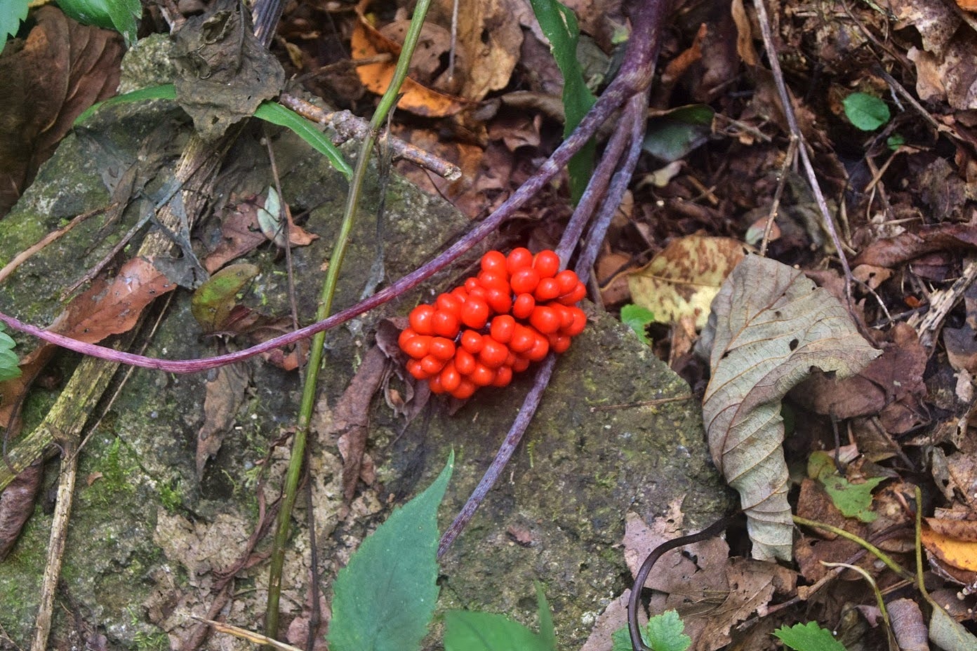
Jack in the pulpit (Arisaema triphyllum) produces bright red berries.
Blog Entries:
20-Oct-2024: Sharp Top Hike
03-Oct-2020: Peaks of Otter Hikes
12-Oct-2014: Peaks of Otter Waterfalls
11-Oct-2014: Clouds on Peaks of Otter
02-Jul-2011: Peaks of Otter Hike
External Links:
Peaks of Otter Lodge website: http://www.peaksofotter.com/
National Park Service website: https://www.nps.gov/blri/planyourvisit/peaks-of-otter-mp-85-6.htm
No comments:
Post a Comment