
Hike Length: 4.4 miles
Estimated Time: 2 to 3 hours
Difficulty: Moderate
Location: North District of Shenandoah National Park
Trail Users: Hiking only
Dogs: Yes
Features: Waterfalls (2)
Crowds: Moderate
Warnings: The rocks around waterfalls are very slippery.
Trailhead GPS: 38.76056,-78.29759
Waterfall GPS: 38.78277,-78.29420 (Overall Run Falls), 38.78079,-78.29111 (Upper Falls)
Directions:
From Charlottesville, head north on US-29 for 23 miles to Madison. Bear left on US-29 Bus north for 1.3 miles and bear left on VA-231 north. Go 20.5 miles and turn left on US-522 north for 0.9 miles. Turn left on US-211 west and go 6.8 miles to the Thornton Gap Entrance Station for Shenandoah on the right. Drive 9 miles north on Skyline Drive and turn left into Mathews Arm Road and park next to the registration station.
Map:

Hike Description:
From the parking area, pick up Traces Trail to the left and follow for 0.3 miles to Mathews Arm Trail and go left. Follow this old road to its end at Tuscarora-Overall Run Trail at 1.8 miles. Turn left here and go just over 0.1 miles and Upper Overall Run Falls will be on the left.
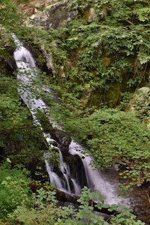
Continue on Overall Run Trail for another quarter-mile to an overlook with views of Overall Run Falls, the highest waterfall in the park.
Overall Run is a very small stream and unless Unless it's rained recently, there may not be much of a waterfall to see.

Even if there isn't much water, the view from the overlook is great.

External Links:
National Park Service website: https://www.nps.gov/thingstodo/overall-run-falls.htm
No comments:
Post a Comment