Contact Information:
300 W. Carolista Drive
Nags Head, NC 27959
Phone: (252) 441-7132
Email: jockeys.ridge@ncparks.gov
GPS: 35.9642, -75.6330
Map:
Trails:
Mountains-to-Sea Trail:
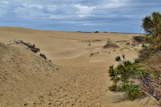
Jockey's Ridge marks the eastern terminus of the statewide Mountains-to-Sea Trail. The trail enters the park at the main entrance and follows a sidewalk to the parking area. It piggybacks on Tracks in the Sand for a short ways, then bears left to lead to the Ridge Top of the dunes. The eastern trailhead is the highest point on the dunes, which is constantly changing.
Soundside Nature Trail:
Distance: 0.6 miles
Soundside Nature Trail starts from the Soundside Road parking lot. It makes a short loop through shrub thicket with views of the dunes and Roanoke Sound.
Tracks in the Sand Trail:
Distance: 1.2 miles
Tracks in the Sand Trail leads from the southwest corner of the parking lot to the dunes. The shifting sands prevent construction of typical trails, so the route is marked by 14 stations. After leading along the dunes, the trail loops around to a view of Roanoke Sound then meets back up with the trail.
Wildlife:
Although the harsh environment of the dunes is inhospitable to most life, a few hardy plants and animals can be found among the dunes. The southern live oak (Quercus virginiana) is one such hardy plant that can withstand such conditions.
Pollen cones of longleaf pine (Pinus palustris)
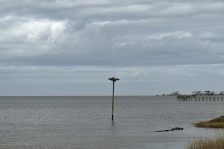
The marshes along the Roanoke Sound are teeming with life. Ospreys (Pandion haliaetus) can be seen hunting for fish in the sound. Tall man-made stands in the sound provide additional nesting space for mating pairs.
Blog Entries:
30-Jan-2021: Outer Banks Hikes
06-Apr-2019: Jockey's Ridge Hikes
30-Dec-2013: Paddling Alligator River
External Links:
NC State Parks website: https://www.ncparks.gov/jockeys-ridge-state-park
Friends of Jockey's Ridge website: https://friendsofjockeysridge.org/


No comments:
Post a Comment