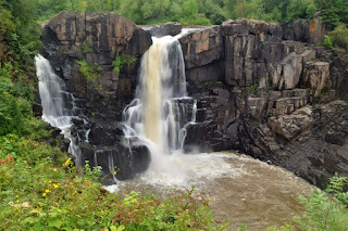
Grand Portage State Park is a 300-acre Minnesota State Park in Cook County. Native Americans and fur traders faced with the 120-foot waterfall and towering cliffs on the Pigeon River had to navigate a nine-mile detour around these obstacles, the Grand Portage. The park was established in 1989 through cooperative efforts between the state of Minnesota and Grand Portage Band of Chippewa Indians. Several trails lead to waterfalls along the Pigeon River separating the United States and Canada, including High Falls, the highest in Minnesota.
Contact Information:
9393 East Highway 61
Grand Portage, MN 55605
Phone: (218) 475-2360
Directions:
From Grand Portage, head north on MN-61 for 5 miles. Immediately before the Canadian border, turn left into the park.
Map:
Trails:
High Falls Trail:
High Falls Trail is a 1-mile round trip hike on a paved trail and boardwalks to views of the waterfall.
Middle Falls Trail:
Middle Falls Trail is a 4.5-mile round trip hike. The trail splits off from High Falls Trail and passes a spur to a scenic overlook at the high point of the park. The trail then forms a loop that leads down to the river at Little Falls and Middle Falls.
Points of Interest:
High Falls:
High Falls, at 120-feet, is the highest waterfall in Minnesota.
Little Falls:
Little Falls is a small cascading waterfall on Pigeon River just upstream of Middle Falls.
Middle Falls:
Middle Falls is a 20-foot waterfall about a mile upstream of High Falls.
Wildlife:
Bigleaf aster (Eurybia macrophylla)
Pear-shaped puffballs (Apioperdon pyriforme)
Scaly pholiota (Pholiota squarrosoides)
External Links:
Minnesota Department of Natural Resource website: https://www.dnr.state.mn.us/state_parks/park.html?id=spk00173#homepage


No comments:
Post a Comment