Hike Length: 2.2 miles
Estimated Time: 1 to 2 hours
Difficulty: Moderate
Location: Lee Ranger District of George Washington National Forest
Trail Users: Hiking, biking and equestrian
Dogs: Yes
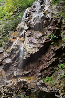
Features: Waterfalls (1)
Crowds: Low
Warnings: The rocks around waterfalls are very slippery.
Trailhead GPS: 38.88145,-78.75972
Waterfall GPS: 38.88422,-78.76972
Directions:
From Harrisonburg, head north on I-81 for about 27 miles to exit 279. Turn left on and drive 4.8 miles on Route 675. Turn right on VA-42 and then left back onto Route 675. Drive another 2.9 miles and turn left on CR-717. In 2.5 miles, turn right on CR-691. Go 0.5 miles and turn left on Forest Road 252. Follow this gravel road 5.2 miles to a small parking area before the gate.
Map:

Hike Description:
Follow FR-252 past the gate for 0.1 miles and turn right on the yellow-blazed Falls Ridge Trail (#572). The trail heads steeply up. After a left-hand switchback, the trail will curve to the right. There is a cairn here. Follow the obvious path to the left. In about 0.1 miles from the trail, the path splits. Go left and down towards the waterfall. You'll pass some big cliffs right before reaching the waterfall.

The water level was a little low when we visited, so best during spring or after a heavy rain.

No comments:
Post a Comment