Sunday, I had breakfast at the hotel, then checked out and headed to Starved Rock State Park. The park is extremely popular, so I wanted to get there early and beat the crowd. Light morning rain also helped keep the tourists at bay. Several parking lots were closed due to flooding so I parked at the lodge. I first headed to French Canyon. A little spur led into the canyon but I couldn't get all the way to the base due to wet rocks, but could still get a decent view of the falls.

Then I passed back by the lodge and headed towards St. Louis canyon. Along the way, I passed Aurora and Sec Canyon. I couldn't find a way to the base of Sec Canyon, but I got an obscured view of the falls from the trail.

Continuing on, there were some interesting sandstone cliffs along the trail. These too had been vandalized.

Canadian columbine was blooming near here.

At the end of Bluff Trail, a spur led into St. Louis canyon. There were some great waterleaf flowering in here.

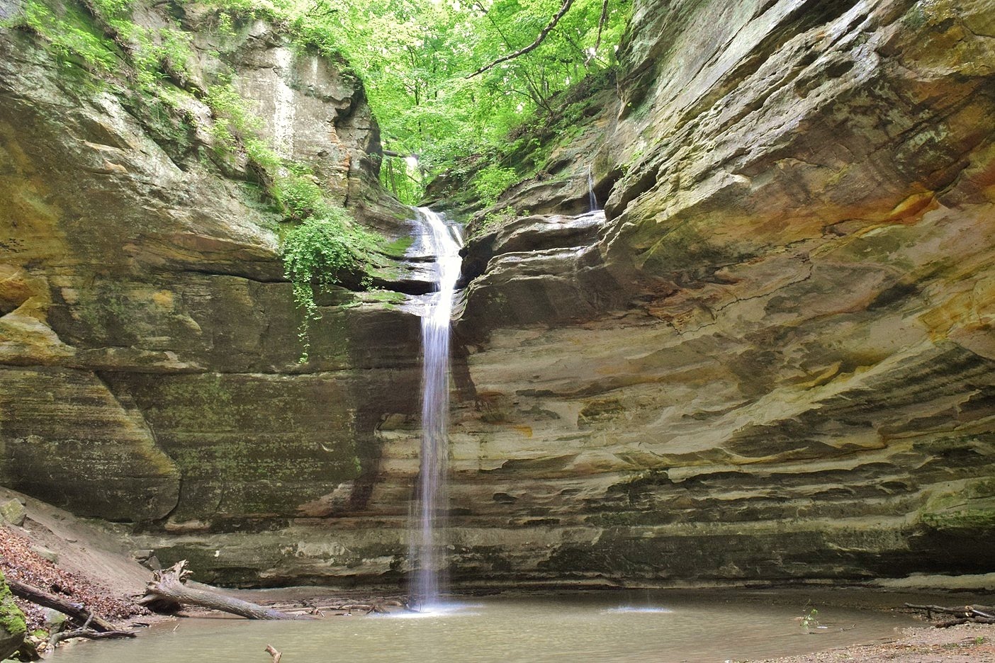
The canyon was really scenic.

And the waterfall at the end was really tall and flowing really well in the high water.

And I had it all to myself.

Hiking back towards the lodge, I made a short detour into Aurora Canyon. The water was low, but still a nice canyon.

Back at the lodge, I got on the Bluff Trail and headed towards Wildcat Canyon. A white-tailed deer ran across the trail and stopped long enough for a picture.

I reached Wildcat Canyon at an overlook on the rim. The main waterfall was visible and there was another smaller one too.

Continuing on, there was another overlook on the other side.

Then, I had to climb the stairs down to get into the canyon. The waterfall in Wildcat Canyon was another really beautiful one.

More people were entering the canyon so I departed to keep my lead ahead of the crowds and climbed back up the steps. Continuing on, the trail became really muddy and slick. And with very steep drop offs, no good options to avoid the mud. I hiked through the mud along Bluff Trail for a ways; before it ended down at the river, I got a view of the Illinois River from Sandstone Point Overlook.

Then I took the stairs down to river level at Lone Tree Canyon. No waterfall in this one - just a lone tree.

A little further along the river was the spur to LaSalle Canyon just across the bridge. More great waterleaf were blooming along this trail.

Soon I made it to the waterfall - I think this was my favorite waterfall and canyon. The water made a 25-foot veil and then a small cascade into a pool.

This waterfall had probably the best flow of them all.

The trail led behind the waterfall and continued to Tonti Canyon. There were actually two waterfalls in this canyon, at least today in the high water, but I could only get a good view of one.

Back on the main trail, I hiked along the river and through the mud to the next canyon - Owl Canyon. A spur led into the canyon, but this one didn't have too much water flowing.

Continuing on, it was more mud to Hennepin Canyon. The trail passes over the waterfall, but there's no way I could find into the canyon and actually see it. And the rim was too overgrown to see anything from up here. Hennepin Overlook was not much further but it was a view of the Illinois River, not the canyon. From here to the road crossing, the mud was exceptionally bad with almost no breaks. Shortly after the road, however, I came to two more canyons. First I headed into Ottawa Canyon and a nice waterfall in here.

The canyon itself was beautiful.

Where there two canyons meet was Council Overhang, a tall overhanging ledge.

It was a little tricky getting into Kaskaskia Canyon and I had to cross the creek a couple times. But it was short to the scenic waterfall.

This waterfall had some down logs on it, but was really pretty nonetheless.

And this would be my last waterfall of the day. I had been planning to continue on to Illinois Canyon, but I had had enough of the mud and it was a long hike back. I stayed close to the river on the hike back and spotted a couple water snakes right at the water's edge.

Just past Lone Tree Canyon was Basswood Canyon, but no waterfall in here.

There were some beautiful Canadian columbine blooming along the river.

I also spotted some wild geranium.

As I got closer to the lodge, I stopped at Eagle Rock Overlook for views of Illinois River.

Lover's Leap Overlook had views on the side of the dam.

There were some white pines and northern white cedar growing here - not a lot of conifers in the park.

I also hiked around the park's namesake, Starved Rock.

There was some invasive honeysuckle flowering here.

By this time, the sun had come out now and it was really crowded so I took off.

After returning the rental car, I checked in to the Holiday Inn and took a shower to get the mud off. I walked to Giardino's for some Chicago deep dish pizza and then packed up. The flight home was uneventful and I actually arrived early.

Then I passed back by the lodge and headed towards St. Louis canyon. Along the way, I passed Aurora and Sec Canyon. I couldn't find a way to the base of Sec Canyon, but I got an obscured view of the falls from the trail.

Continuing on, there were some interesting sandstone cliffs along the trail. These too had been vandalized.

Canadian columbine was blooming near here.

At the end of Bluff Trail, a spur led into St. Louis canyon. There were some great waterleaf flowering in here.

The canyon was really scenic.

And the waterfall at the end was really tall and flowing really well in the high water.

And I had it all to myself.

Hiking back towards the lodge, I made a short detour into Aurora Canyon. The water was low, but still a nice canyon.

Back at the lodge, I got on the Bluff Trail and headed towards Wildcat Canyon. A white-tailed deer ran across the trail and stopped long enough for a picture.

I reached Wildcat Canyon at an overlook on the rim. The main waterfall was visible and there was another smaller one too.

Continuing on, there was another overlook on the other side.

Then, I had to climb the stairs down to get into the canyon. The waterfall in Wildcat Canyon was another really beautiful one.

More people were entering the canyon so I departed to keep my lead ahead of the crowds and climbed back up the steps. Continuing on, the trail became really muddy and slick. And with very steep drop offs, no good options to avoid the mud. I hiked through the mud along Bluff Trail for a ways; before it ended down at the river, I got a view of the Illinois River from Sandstone Point Overlook.

Then I took the stairs down to river level at Lone Tree Canyon. No waterfall in this one - just a lone tree.

A little further along the river was the spur to LaSalle Canyon just across the bridge. More great waterleaf were blooming along this trail.

Soon I made it to the waterfall - I think this was my favorite waterfall and canyon. The water made a 25-foot veil and then a small cascade into a pool.

This waterfall had probably the best flow of them all.

The trail led behind the waterfall and continued to Tonti Canyon. There were actually two waterfalls in this canyon, at least today in the high water, but I could only get a good view of one.

Back on the main trail, I hiked along the river and through the mud to the next canyon - Owl Canyon. A spur led into the canyon, but this one didn't have too much water flowing.

Continuing on, it was more mud to Hennepin Canyon. The trail passes over the waterfall, but there's no way I could find into the canyon and actually see it. And the rim was too overgrown to see anything from up here. Hennepin Overlook was not much further but it was a view of the Illinois River, not the canyon. From here to the road crossing, the mud was exceptionally bad with almost no breaks. Shortly after the road, however, I came to two more canyons. First I headed into Ottawa Canyon and a nice waterfall in here.
The canyon itself was beautiful.

Where there two canyons meet was Council Overhang, a tall overhanging ledge.

It was a little tricky getting into Kaskaskia Canyon and I had to cross the creek a couple times. But it was short to the scenic waterfall.

This waterfall had some down logs on it, but was really pretty nonetheless.

And this would be my last waterfall of the day. I had been planning to continue on to Illinois Canyon, but I had had enough of the mud and it was a long hike back. I stayed close to the river on the hike back and spotted a couple water snakes right at the water's edge.

Just past Lone Tree Canyon was Basswood Canyon, but no waterfall in here.

There were some beautiful Canadian columbine blooming along the river.

I also spotted some wild geranium.

As I got closer to the lodge, I stopped at Eagle Rock Overlook for views of Illinois River.

Lover's Leap Overlook had views on the side of the dam.

There were some white pines and northern white cedar growing here - not a lot of conifers in the park.

I also hiked around the park's namesake, Starved Rock.

There was some invasive honeysuckle flowering here.

By this time, the sun had come out now and it was really crowded so I took off.

After returning the rental car, I checked in to the Holiday Inn and took a shower to get the mud off. I walked to Giardino's for some Chicago deep dish pizza and then packed up. The flight home was uneventful and I actually arrived early.


