Sunday, February 17, 2019

Fayetteville Waterfalls

Sunday, we checked out of the hotel and headed north towards Fayetteville.  We first drove to J. Bayard Clark Park and Nature Center and the Cape Fear River Trail parking.  After getting our stuff together, we headed into the park.  Clark Park Falls is right behind the Nature Center.


It's not a huge waterfall, but pretty impressive being in Fayetteville.  Right next to the nature center was a covered bridge.


Across the bridge, we could get to the other side of the gorge for some more pictures of the falls.  There was a lot of down trees in the gorge so hard to get an unobstructed view.


Then we set off on the Cape Fear River Trail heading north.  This paved greenway trail is part of the East Coast Greenway.  About two thirds of the way, the trail runs over a covered bridge under the railroad tracks.


After the railroad tracks, the trail crosses another bridge over Sandy Dam on a tributary of Cap Fear River.  There was another waterfall here.  The upper part is over a manmade dam but it was really scenic in high water.


Another unexpected waterfall in Fayetteville.  We followed the trail to the end at Jordan Soccer Complex and turned around.  Our next stop was at Methodist University.  Parking at the baseball fields at the back of the campus, we hiked the Pauline Longest Nature Trail system to another tributary waterfall.


This one fell into a small slot canyon.  Really scenic and out of the ordinary for here in the Sandhills.  After some pictures, we started making back and driving home.


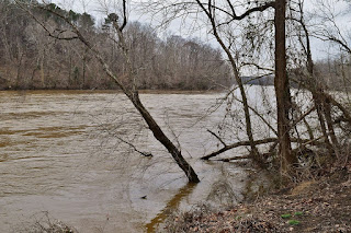
Near Erwin, we parked at the Cape Fear River Trail Park.  A half-mile gravel road ran along the river parallel to the road and factory.  Right past the factory, a connector trail led to the Dunn-Erwin Greenway Trail.  The trail ended where a small tributary dropped into Cape Fear River.


And there was another small waterfall down here.  I found a way down to river level here.


It was tricky getting back up the tributary for a picture of the waterfall.


When we were done, we headed back to the car and finished making the drive home.

Saturday, February 16, 2019

Lake Waccamaw and Lumber River

On Saturday we headed to southeastern North Carolina for some hiking and umexpected waterfalls.  We first headed to Lake Waccamaw State Park, arriving around 10.  First, we got Alex's passport stamped.


On display in the Visitor Center was a whale fossil that had been discovered in the lake, evidence that this area was once a shallow sea.


Then we followed Boardwalk Trail 2 down to the lake.  It was lightly drizzling when we started but stopped shortly.  The boardwalk ended at a nice view of the lake.


Then we got on the Lake Shore Trail and headed south.


This trail leads about four miles right along the shore of the lake.  As it stays close to the shore, there are plenty of great views of the lake.  We spotted an interesting looking reindeer lichen along the trail.


Soon we approached Boardwalk Trail.


This one is longer and goes way out into the lake.


A little further, we passed through the campsites.  One had a yurt, for slightly less primitive camping.  After, the campsites, the trail continued along the lake.  At one point, the trail was surrounded on one side by the lake and the other by a swamp.


There were also several nice little beaches to stop for a break and enjoy the view.


We finished up at the small dam on the lake.


The trees around the dam were really covered in Spanish moss.


A recently completed boardwalk over the dam led to a parking area.


From here, we turned around to start heading back.  At the camping area, we took the Pine Woods Trail to make a partial loop back.  The trail first passes through an area where longleaf pine are growing.


Further on, it was through a more mature pine forest.


This trail made a nice contrast from the swampy and wet area along the lake.  Pine Woods Trail ends at Loblolly Trail, also passing through pine woods.


A right turn led a half-mile back to the visitor center.


Leaving Lake Waccamaw, we headed west to our next stop, Princess Ann area of Lumber River State Park.  The park office is closed on weekends, but they have an outside box for stamps for Alex's passport.


We set off on the short Griffin's Bluff Trail that led along the bluff on the river.  There were nice views of the river from here.  The trail turned around at Griffin's Whirl, an interesting reverse flow section of the river.


In high water, it was obvious the main path of the river.


From here, the trail looped back around up along the bluff.  It was here that the community of Princess Ann was located, safely up on the bluff.  As railroad travel increased and river travel decreased, the town dwindled away and now nothing remains but the road named for it.  There was an old log from when this area was extensively logged.


This log was so big and heavy, it couldn't be moved; it was too big for even the sawmill.  Finishing up the loop, we went down to the boat ramp for a few more pictures of the river.


Then we took off and headed toward Lumberton.


We got take-out from Village Station and checked in to the Best Western, a dog friendly hotel.  It was Alex's first stay in a hotel and he enjoyed sleeping with us on the king size bed.

Sunday, February 10, 2019

Merchants Millpond Hike

Sunday morning, it was very cold when we woke up and it was tough getting out of the tent.  After we got our stuff together, we drove to the visitor center at Merchants Millpond State Park to park and hike the entire Lassiter Trail today.  First, we got Alex's passport stamp.


It was quite chilly this morning, but hiking at a brisk pace kept us warm.  We stopped again at the scenic boardwalk near the picnic area - I think this is the most scenic part of the trail.


After splitting away from the Fire Road, the trail led past Lassiter Swamp, where Merchants Millpond begins.


After this point, it looped back around and soon we were on familiar trail again.  Back at the visitor center, we headed down to the boat dock for a nice view of the millpond.


We couldn't paddle today since we had Alex, so got on Bennetts Creek Trail and followed it to a road crossing.  Across the road, the trail made a partial loop.  There was an overlook about half way through the loop with a view of the swampy Bennetts Creek downstream from the millpond.


The trail finished up back at the road and we crossed over the dam.


At the boat ramp parking, we hiked the Coleman Trail, another 2-mile loop.  We stopped for a break and spotted an interesting mushroom growing on a dead pine tree.


The trail led to another view point on Merchants Millpond.


After we finished the loop, we followed the road back to Bennetts Creek Trail and finished our hike back at the visitor center.  We were all pretty tired by this point and it was an uneventful drive home.

Saturday, February 9, 2019

Flat Tire

Sandy had this past weekend off, so we took Alexander out for a weekend of camping and hiking.  Our plan was to head out to Dismal Swamp State Park and then camp at Merchants Millpond.  We left early Saturday morning and about 30 minutes from Dismal Swamp, we got a flat tire, conveniently in the middle of nowhere.  I was able to change it out for the donut and we continued to the park, which is right next to a rest area so hopefully a better location to deal with our tire issue.  I went into the visitor center to get Alex's passport stamped.


Since I was here, I asked the ranger where we might get another tire since we couldn't make it back to Raleigh on a donut.  He suggested a couple places that might be open on a Saturday.  Alex was getting very frustrated being stuck in the car for so long, so before we left, we took him for a short hike around the Swamp Boardwalk trail.


It makes a figure-8 through the Great Dismal Swamp.


Then we headed back across the bridge over the canal.


This canal runs from Virginia south and is part of the intercoastal waterway managed by the Army Corps of Engineers.


From here, we headed to Tom Perry's in Sunbury.  He had a used tire that he put on the car that would get us home and was a real life saver.  By this time, we were hungry so went to China King for take-out and had a picnic lunch at Merchants Millpond State Park.  After lunch, we checked in and set up our tent at the family campground.  It was still early and Alex needed to get some hiking in, so we took the campground spur to Lassiter Trail.  The trail crosses a tributary on a boardwalk at one of the most scenic parts of the millpond.


Further on, there were some more scenic views of the swamp.


We would be hiking this trail tomorrow so, used the fire roads to mix it up a bit.


As we finished up the loop, the sun was getting lower in the sky.


The pond was really pretty in the evening light.


Lots of cypress knees all along the shore.


When we finished up, we started a fire back at camp.  It was nearing sunset so I headed back to the Millpond for some last pictures.


It got really cold after the sun went down so we made a big fire to keep warm.  Even Alex wrapped up in a blanket to sleep - not too often that he gets cold.