Saturday, we took Alex for some hikes up to Kerr Lake on the Virginia state line. Our first stop was the visitor center for Kerr Lake State Recreation Area at Satterwhite Point Recreation Area, still in North Carolina. After getting Alex's passport stamped, we set off for a short hike.

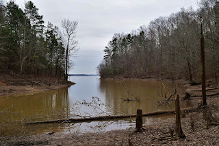
Kerr Lake State Recreation Area is comprised of seven access areas around the North Carolina side of the lake. Most of the amenities are for camping and lake activities, with just a couple of short trails. We hiked the Forestry Trail, the park's Track Trail. The trail starts off paved and spur led out to a bench with a view of the lake.

Being winter, the views were enhanced by the lack of foliage. Continuing on, the trail turned to natural surface after the amphitheater and followed the lake shore. There were a couple other spots to go out for a view of the lake.

There was also an old cemetery off the trail with the grave marker for Richard Henderson, the father of North Carolina Supreme Court Justice Leonard Henderson, for whom the nearby city of Henderson is names.

The trail ended after about 3/4 of a mile and we turned around here.

Back at the car, we continued north into Virginia to Greenwood Wildlife Management Area at the western trailhead for Robert Munford Trail. This trail led along the lake's shore on land owned by the Army Corps of Engineers as part of John H. Kerr Dam and Reservoir. The trail is named for Robert Munford III, a prominent citizen of Mecklenburg County in the late 18th century. The main trail was blazed purple and followed an old road. In under a mile, we turned right where the blazes were blue to lead out to the cemetery where Robert Munford is buried.

To make a loop, we followed a white-blazed trail back to the main trail. There were some nice views of the lake along here.
We also found what seemed to be the remains of and old home site.

Back on the main trail, we turned right to continue following the purple blazes. The trail leads to a trailhead near Eagle Point Recreation Area after about 7 miles, but we didn't go the whole way. We turned around at a tributary near the Taylor's Ferry Road and made the hike back. Some holly trees still had berries on them.

To make the hike a little shorter, we stayed on the purple-blazed road and bypassed the trails leading back out to the cemetery.


Kerr Lake State Recreation Area is comprised of seven access areas around the North Carolina side of the lake. Most of the amenities are for camping and lake activities, with just a couple of short trails. We hiked the Forestry Trail, the park's Track Trail. The trail starts off paved and spur led out to a bench with a view of the lake.

Being winter, the views were enhanced by the lack of foliage. Continuing on, the trail turned to natural surface after the amphitheater and followed the lake shore. There were a couple other spots to go out for a view of the lake.

There was also an old cemetery off the trail with the grave marker for Richard Henderson, the father of North Carolina Supreme Court Justice Leonard Henderson, for whom the nearby city of Henderson is names.

The trail ended after about 3/4 of a mile and we turned around here.

Back at the car, we continued north into Virginia to Greenwood Wildlife Management Area at the western trailhead for Robert Munford Trail. This trail led along the lake's shore on land owned by the Army Corps of Engineers as part of John H. Kerr Dam and Reservoir. The trail is named for Robert Munford III, a prominent citizen of Mecklenburg County in the late 18th century. The main trail was blazed purple and followed an old road. In under a mile, we turned right where the blazes were blue to lead out to the cemetery where Robert Munford is buried.

To make a loop, we followed a white-blazed trail back to the main trail. There were some nice views of the lake along here.

We also found what seemed to be the remains of and old home site.

Back on the main trail, we turned right to continue following the purple blazes. The trail leads to a trailhead near Eagle Point Recreation Area after about 7 miles, but we didn't go the whole way. We turned around at a tributary near the Taylor's Ferry Road and made the hike back. Some holly trees still had berries on them.

To make the hike a little shorter, we stayed on the purple-blazed road and bypassed the trails leading back out to the cemetery.

No comments:
Post a Comment