Tuesday, I woke up and had breakfast at the hotel before checking out. My first hike of the day was just a short drive to Falling Waters State Park, home to Florida's highest waterfall. After paying admission, I drove to the main parking lot and set out. It was just a short walk on a concrete pathway down to Falling Waters Sink.

A small creek tumbles down 72 feet deep into a sinkhole - Florida's highest waterfall. The overlook is partly down in the sinkhole and provides great views looking down into the sinkhole as the water disappears into an unknown cavern.

This is a really unique waterfall - Florida may not have many, but this one sure is cool. After some pictures, I figured I'd hike around the small park. I got on Wiregrass Trail and shortly came to the capped oil well.

One of the first oil wells in Florida was drilled here. They drilled down more than 4000 feet, but never found a commercially-feasible quantity and capped the well in 1921. Past here, the trail came out at Falling Waters Lake.

From the lake I took Terrace Trail up towards the campground. There were quite a few azaleas in bloom.

I think these are mountain azalea.

I also spotted some longleaf pine in the grassy stage. One had a candle sticking up from the top, indicating it would start growing vertically soon.

After finishing up the short trails, I headed back to the car.

I got back on I-10 east towards Tallahassee and into Apalachicola National Forest. Parking at Leon Sinks Geological Area, I got ready to hike the loop and see the many sinkholes in this fascinating area. Starting on the Sinkhole Trail, I went right at the T-intersection and passed the first couple sinkholes, which were dry and barely noticeable. The first one I could really tell was a sinkhole was Turner Sink.

It had some beautiful flowering dogwood blooming around it.

Next, I came to Palmetto Sink - obvious how this one got its name with the saw palmetto all around.

Past here was Back Sink and then I came to the gorgeous Hammocks Sink, my favorite of the holes. This sinkhole was wet and filled with the most beautiful blue-green water.

Professional cave divers had explored the underwater caves below this sinkhole, discovering more than 28 miles of caves that connect to Wakulla sinks, 10 land miles away. Shortly past here was Tiny Sink, which as the name suggests, was very small.

The next one was not small at all - Big Dismal Sink. Big Dismal is the biggest in the area and the viewing deck was way above the sinkhole.

The view was partly obscured by foliage but it was pretty amazing to see it. Continuing on the Sinkhole Trail, the next one was Big Eight Sink though there wasn't much to see.

Magnolia Sink was just past this, but it was so full of downed trees, the sinkhole wasn't even visible.

A little further on was Black Sink, presumably named for the dark, tannic water in the sinkhole.

Next I came to Fisher Creek, the lost stream, which disappears into another sinkhole after flowing for less than a mile.

Duckweed Sink was on the other side of the ridge.

From here, it was just a short ways to finish up Sinkhole Trail near where Fisher Creek rises.

The trail had passed over a natural bridge that crossed over Fisher Creek, where it drops into a sinkhole and flows under the trail.

Fisher Creek rises on the other side then flows down to where I had been earlier. At this point, I got on the Gum Swamp Trail and hiked through a very different landscape. There were lots of palmetto growing along the trail and I spotted some mountain azalea blooming.

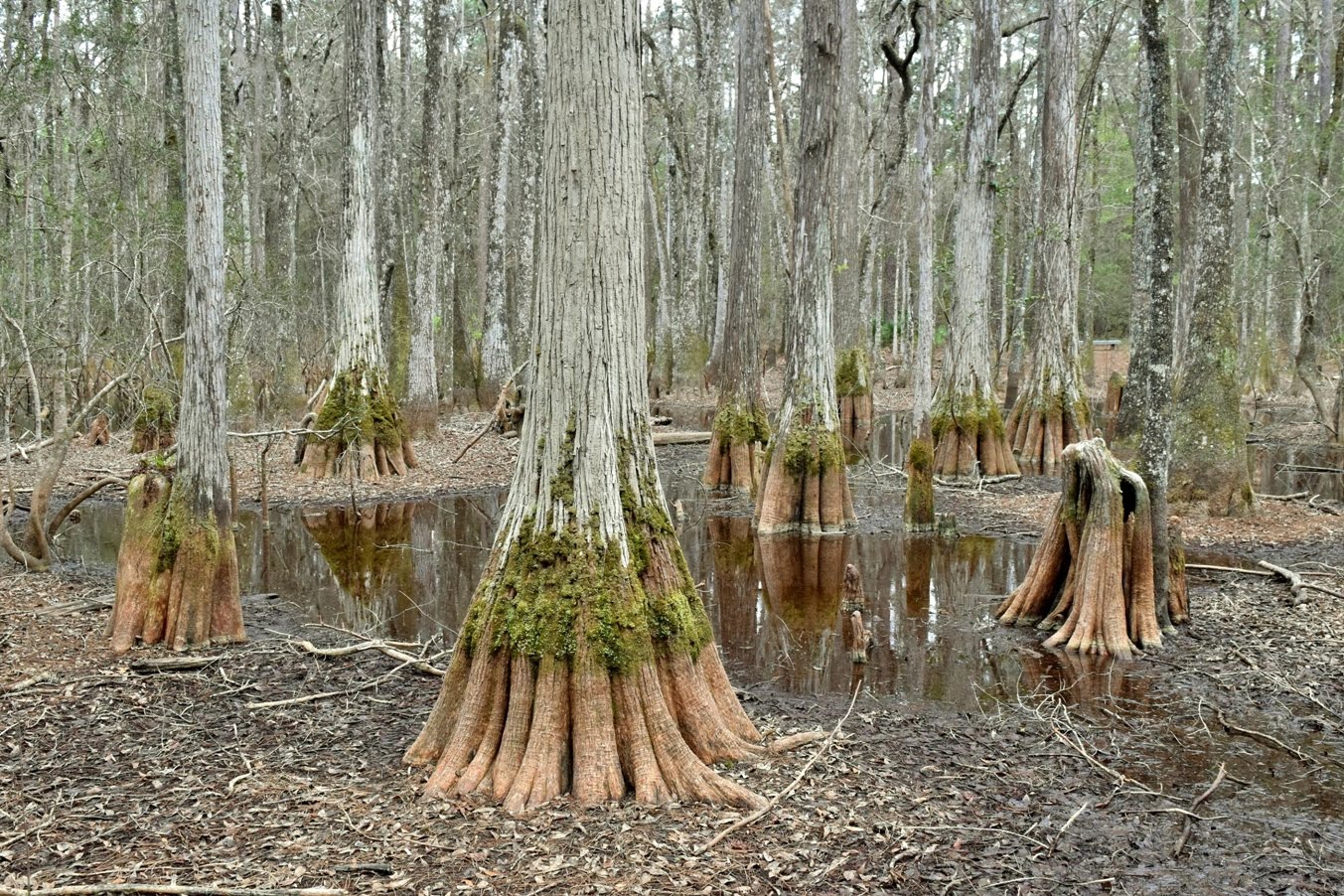
As the name suggests, there were several swamps along the trail. The first was Bear Scratch Swamp with really beautiful tupelo gum trees.

The next was South Swamp along the southern boundary of the area.

And the last was Shadows Swamp.

Past here, Gum Swamp Trail ended at the junction with Sinkhole and Crossover Trail. Turning left, I got on Crossover Trail to a long boardwalk.

It led across Center Swamp with nice views of the giant trees.

Finishing up this trail, I got back on Sinkhole Trail and made a quick detour on Hutchison's Spur to Gopher Hole.

This was really more of a cave than a sinkhole. It was just a short ways back to the parking.

Back at the car, I started heading west, making a stop near Bristol at Apalachicola Bluffs & Ravines Preserve, a Nature Conservancy property. The Garden of Eden Trail starts out following an old road through a pine savanna.

The first half mile or so was very flat, but then it entered a more forested area and dropped steeply into a ravine. Hard to believe such a drastic change in topography. The trail followed a ridge and then dipped back down into another ravine at Kelley Branch. The Nature Conservancy removed a dam and is restoring this tributary of Apalachicola River. There were some beautiful Florida anise blooming down here.

Across the ravine, the trail headed steeply up and then through another flat savanna. I some some longleaf pine saplings in the grassy stage along here.

At the edge of the savanna was a split and I went right. There was some Spanish moss draping from branches over the trail.

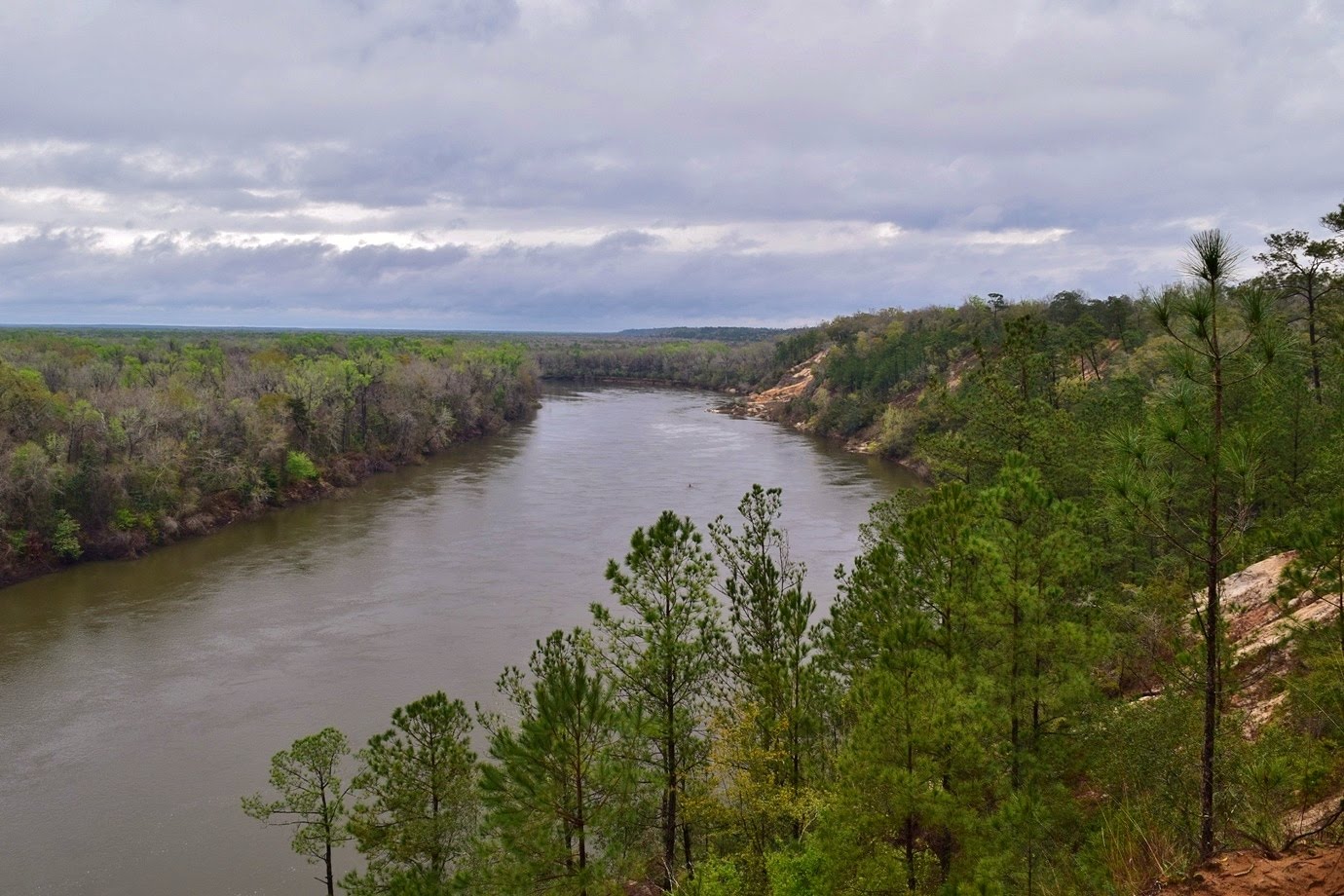
Then it came out on the high bluff above Apalachicola River.

The view from up here was great and I could see Alum Bluffs in the distance. The trail followed the bluffs for a ways with a couple more nice viewpoints high above the river.

At the edge of the bluff, the trail dipped back down into a ravine and climbed back up to finish the loop. A surprisingly strenuous hike for Florida with a lot of elevation change. It was a really cool and beautiful area, though the mosquitoes were really bad.

From here, I drove about 2 hours west to Pensacola and spent the night at the Holiday Inn.

A small creek tumbles down 72 feet deep into a sinkhole - Florida's highest waterfall. The overlook is partly down in the sinkhole and provides great views looking down into the sinkhole as the water disappears into an unknown cavern.

This is a really unique waterfall - Florida may not have many, but this one sure is cool. After some pictures, I figured I'd hike around the small park. I got on Wiregrass Trail and shortly came to the capped oil well.

One of the first oil wells in Florida was drilled here. They drilled down more than 4000 feet, but never found a commercially-feasible quantity and capped the well in 1921. Past here, the trail came out at Falling Waters Lake.

From the lake I took Terrace Trail up towards the campground. There were quite a few azaleas in bloom.

I think these are mountain azalea.

I also spotted some longleaf pine in the grassy stage. One had a candle sticking up from the top, indicating it would start growing vertically soon.

After finishing up the short trails, I headed back to the car.

I got back on I-10 east towards Tallahassee and into Apalachicola National Forest. Parking at Leon Sinks Geological Area, I got ready to hike the loop and see the many sinkholes in this fascinating area. Starting on the Sinkhole Trail, I went right at the T-intersection and passed the first couple sinkholes, which were dry and barely noticeable. The first one I could really tell was a sinkhole was Turner Sink.

It had some beautiful flowering dogwood blooming around it.

Next, I came to Palmetto Sink - obvious how this one got its name with the saw palmetto all around.

Past here was Back Sink and then I came to the gorgeous Hammocks Sink, my favorite of the holes. This sinkhole was wet and filled with the most beautiful blue-green water.

Professional cave divers had explored the underwater caves below this sinkhole, discovering more than 28 miles of caves that connect to Wakulla sinks, 10 land miles away. Shortly past here was Tiny Sink, which as the name suggests, was very small.

The next one was not small at all - Big Dismal Sink. Big Dismal is the biggest in the area and the viewing deck was way above the sinkhole.

The view was partly obscured by foliage but it was pretty amazing to see it. Continuing on the Sinkhole Trail, the next one was Big Eight Sink though there wasn't much to see.

Magnolia Sink was just past this, but it was so full of downed trees, the sinkhole wasn't even visible.

A little further on was Black Sink, presumably named for the dark, tannic water in the sinkhole.

Next I came to Fisher Creek, the lost stream, which disappears into another sinkhole after flowing for less than a mile.

Duckweed Sink was on the other side of the ridge.

From here, it was just a short ways to finish up Sinkhole Trail near where Fisher Creek rises.

The trail had passed over a natural bridge that crossed over Fisher Creek, where it drops into a sinkhole and flows under the trail.

Fisher Creek rises on the other side then flows down to where I had been earlier. At this point, I got on the Gum Swamp Trail and hiked through a very different landscape. There were lots of palmetto growing along the trail and I spotted some mountain azalea blooming.

As the name suggests, there were several swamps along the trail. The first was Bear Scratch Swamp with really beautiful tupelo gum trees.
The next was South Swamp along the southern boundary of the area.

And the last was Shadows Swamp.

Past here, Gum Swamp Trail ended at the junction with Sinkhole and Crossover Trail. Turning left, I got on Crossover Trail to a long boardwalk.

It led across Center Swamp with nice views of the giant trees.

Finishing up this trail, I got back on Sinkhole Trail and made a quick detour on Hutchison's Spur to Gopher Hole.

This was really more of a cave than a sinkhole. It was just a short ways back to the parking.

Back at the car, I started heading west, making a stop near Bristol at Apalachicola Bluffs & Ravines Preserve, a Nature Conservancy property. The Garden of Eden Trail starts out following an old road through a pine savanna.

The first half mile or so was very flat, but then it entered a more forested area and dropped steeply into a ravine. Hard to believe such a drastic change in topography. The trail followed a ridge and then dipped back down into another ravine at Kelley Branch. The Nature Conservancy removed a dam and is restoring this tributary of Apalachicola River. There were some beautiful Florida anise blooming down here.

Across the ravine, the trail headed steeply up and then through another flat savanna. I some some longleaf pine saplings in the grassy stage along here.

At the edge of the savanna was a split and I went right. There was some Spanish moss draping from branches over the trail.

Then it came out on the high bluff above Apalachicola River.
The view from up here was great and I could see Alum Bluffs in the distance. The trail followed the bluffs for a ways with a couple more nice viewpoints high above the river.

At the edge of the bluff, the trail dipped back down into a ravine and climbed back up to finish the loop. A surprisingly strenuous hike for Florida with a lot of elevation change. It was a really cool and beautiful area, though the mosquitoes were really bad.

From here, I drove about 2 hours west to Pensacola and spent the night at the Holiday Inn.
No comments:
Post a Comment