Wednesday, December 26, 2018

Crowders Mountain Day Hike

Wednesday, Sandy and I both had off, so we took Alex for a day hike at Crowders Mountain State Park.  We got to the park around 10 and first got Alex's passport stamped.


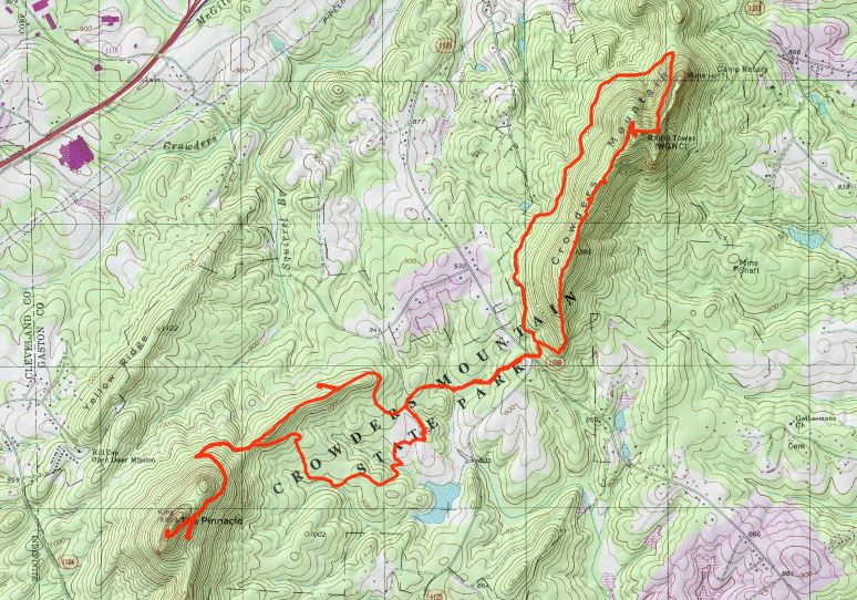
Then we set out on Crowders Trail to the park's namesake.  Across the road, we turned right to get on Rock Top Trail and started climbing steeply up the ridge.


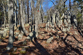
There are some great rock scrambling sections along this trail.  We took a break once up on the ridge to enjoy the views.


At one spot, there was a nice view of the cliffs along Crowders Mountain with the Charlotte skyline visible in the distance.


Then we continued on to the summit of Crowders Mountain.  It was crowded here with hikers and rock climbers so we didn't stay long.  Taking Backside Trail back down, we turned left on Crowders Trail and took that back towards the visitor center.  Going straight, we got on Pinnacle Trail and headed up to the highest point in the park.


The last rock scramble to get up to the top is a little tricky and Alex was having trouble.  So I found an easier way to get up and we had a nice break up here.


There were some nice views up here, but it was pretty crowded too.


On the way, to make a loop, we took Turnback Trail to go back to the visitor center.  This trail was a lot less crowded than the others.


Before heading home, we stopped in Gastonia and had a great dinner at Hickory Tavern.  The staff were very sweet to Alex.  After dinner, we made the drive home.

Monday, December 24, 2018

Cedarock and Eno Riverwalk

Monday was a holiday so I headed to Cedarock Park south of Burlington for a hike.  I parked near the Park Office and restrooms and picked up Rock Creek Trail near the picnic area.  The trail descended down to the creek and then made a loop - I went left, crossing rock creek twice and reaching another split.  Rocky Branch, a small tributary tumbled down into the creek at a bridge.


Across the bridge was a second loop on Rock Creek Trail and I went left again.  A little further, I passed the old mill dam.


Although not natural, the waterfall over the dam was quite scenic and higher than I expected.


Continuing on the paved Curtis Mill Trail, I stopped for some pictures on the other side of the creek.


Then I got back on the first loop and continued on.  Near the end, I took the Connector Trail to hit the other side of the park.  The connector trail is a loop and I first went on the lower portion.  It was really muddy and swampy being in the Rock Creek floodplain.  I was glad there was an alternative for the way back.  At the other end, I picked up Spoon Branch Trail and went left, following its namesake up.


Then I looped back around the other side of the stream and took the bridge over Rock Creek.  The trail led up to the parking at Garrett Historical Farm.  Along the way, it passed a nice little waterfall on Fox Branch.


Finishing up the loop on Spoon Branch Trail, I took the upper Connector Trail to avoid the swampy mess and then Rock Creek Trail back to my car.


Sandy was still working and I wanted to get another hike in, so I stopped in Hillsborough along the way at Gold Park.  The town's Riverwalk along the Eno is now part of the Mountains-to-Sea Trail.  From Gold Park, I followed the trail eastbound through Hillsborough along Eno River.  Right past the park, the trail passed under an old railroad bridge.


The paved greenway trail follows right along the river with nice views.


And it passes right through downtown Hillsborough, so a great way to get around town.  A Sight to Behold, a Stickwork sculpture was right off the trail.


Where the Riverwalk ended, a gravel road led through the Classical American Homes Preservation Trust sites, including the Historic Occoneechee Speedway.  Past the speedway, the trail led through James M. Johnston Nature Preserve.  The trail was a bit more rugged here - narrow, steep and rocky.


It wasn't a long section, but very scenic and I enjoyed it.  The trail ended at US-70 and it's road walking from here to Eno River State Park, so I turned around.

Sunday, December 23, 2018

Haw River State Park

Sunday morning, it was quite cold when we woke up.  Alex had kept us warm in the tent, but it was rough getting out.  After breakfast, we broke camp.  Alex seemed quite disappointed that we were taking down the tent - he really loves camping.  Sandy had to work in the evening, but we wanted to get a hike in on the way home.  Our original plan was Guilford Courthouse National Military Park in Greensboro, but it was closed with the federal government shutdown.  So instead, we went to Haw River State Park north of Greensboro.  First, we went to the visitor center at the Summit Center area of the park.


After getting Alex's passport stamped, we hiked the Piedmont Loop Trail.  Heading down, we stopped to see Robins Nest Lake.


Continuing on, there was a split with Wetlands Boardwalk.


The boardwalk to the north headed out to a scenic view of Haw River.


The main trail then looped back around to the lake and back to the visitor center.  Next, we headed to the Iron Ore Belt Access Area to hike the Great Blue Heron Loop.


Although the trail didn't get too close to Haw River, the flood plain was completely underwater.


North Carolina's gotten so much rain this year.  After finishing up the loop, we started making our way home.

Saturday, December 22, 2018

Lake Norman Camping

Saturday, we took Alex to go camping at Lake Norman State Park.  We got there around 10 and parked at the Visitor Center to get Alex's passport stamped.


Then we started hiking the short Alder Trail.  This trail follows the little peninsula behind the Visitor Center between Norwood Creek and Hicks Creek, staying very close to the lake shore.  With all the recent rain and melting snow, the water level was way up.  A short spur went out to the dam and spillway that formed the Park Lake.


It was a scenic little spot with the visitor center visible across the small lake.  After a short break, we got back on the main trail and continued around the loop.


There were several other spots along the trail to go out for a view of the lake.  With the water so high, it was very brown and full of sediment.


Where the trail looped back to the beginning, we took the paved Dragonfly Trail to an overlook.


Then it was back to the parking lot.  Continuing further into the park, we next stopped at the trailhead for Lake Shore Trail.  This is the longest hiking trail in the park at about 5 miles in a loop.  We started hiking north along the trail.  The lake was very scenic.


After crossing the park road there was a split where left was a spur to the Group Camp.  We took the short spur to add a little distance.


This spur crossed a scenic little tributary - it wasn't marked on the topo map but there was a little water flowing today.  Continuing on, the trail passed the Boat Launch and then looped around the southern part of the park.


Across the lake were some really huge lake homes.  I really enjoyed this trail - it was hilly enough to be a nice workout but not too strenuous.  And the trail never departed from the shoreline, there were a lot of great views.  I spotted some orange jelly fungus growing on a pine tree.


Past here, a short spur led up to the campsite where we would be spending the night.  Soon the trail came back to the trailhead where we had parked.  It was a little too early to check in to camp, so we headed into Troutman and had dinner at Kyjo's.  We split hibachi and a sushi roll.  Then it was back to camp to set up at site #1.  Being winter, the park was not crowded, so no one else camping near us.  But the sites were really spacious - it was a very nice campground.  We got the tent all set up with just over a half-hour to sunset.  So we took the little spur trail down to the lake to a great spot looking west.


It was a really beautiful sunset!


The sky lit up in pink, orange and purple as the sun went behind the horizon.


As it started to get dark, we made our way back to the campsite and built a nice bonfire.


It got real cold over night so the fire was great to keep us warm.  Then we retired for the evening.  As a husky, Alex makes an excellent space heater for the tent!

Saturday, December 1, 2018

Goose Creek Hike

Saturday, we took Alex for a day hike to Goose Creek State Park.  First, we stopped at the visitor center to get Alex's passport stamped.


The park had taken some damage hiking Hurricane Florence and the far end of Palmetto Boardwalk was closed.  So we did this one as an out and back.  The boardwalk leads through a beautiful swamp and then a more open marsh area.


At the caution tape was our turnaround point.  Since the boardwalk doesn't connect to the other trails we parked at Ivey Gut Trailhead and started hiking Tar Kiln Trail.  As the name suggests, the trail passes the remains of several old tar kilns. Some were hard to discern with all the newly fallen trees.  At the end we turned left on Mallard Creek Trail and went out to the overlook.


From here, we got on Live Oak Trail to head towards the beach on Pamlico River.  I think this is the nicest part of the park and that's saying a lot.


Live oaks with branches draped in Spanish moss hang over the Pamlico River.


We found a nice spot to sit and have a break enjoying the views.


Past the Swim Beach, we took Goose Creek Trail that parallels Pamlico towards its namesake.  Boardwalks traverse a gum and cypress swamp.


Although most of the leaves were down, there were still a few patches of color.


At the far end, there is a tree with the ground around it completely eroded away, but it's still standing strong - even with another tree haven fallen on it.  Past the campsites is a canoe launch for Goose Creek.


We backtracked a short ways and then got on Ivey Gut Trail.  We did the loop with a couple spots to go out for views of Goose Creek.


There was a lion's mane mushroom growing on the tree here.


Some of the boardwalks here had been damaged by the hurricane, but were passable.  This trail finished back up at our parking lot.


On the way home, we stopped at Flower Hill Nature Preserve in Johnston County, so Alex could get a hike for TLC challenge.


It was raining now, but only lightly.  We hiked out to the end of the property and back.  The south-facing bluffs along Moccasin Creek support an unusual population of Catawba rhododendron.


They weren't blooming now, but are still noticeable.  The only leaves that were still orange were the beech trees.


We finished the hike back at the car and drove the rest of the way home.