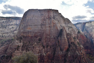
Thursday, we had breakfast and headed back to Zion National Park one last time. We were planning to hike to Angels Landing and this is one of the most popular hikes in the park, so we wanted to get an early start. We parked at the visitor center and took the shuttle to stop #6, the Grotto. Crossing the street and the river on a footbridge, we turned right to hike West Rim Trail. The trail starts out gradual with nice views of the Virgin River and Angels Landing towering above.

We could also see Weeping Rock and Red Arch Mountain from the trail.

Soon, the trail begins to get steeper and switchback up into Refrigerator Canyon.

Finally, as we approached Angels Landing, the trail entered the canyon and leveled off a bit. There was some beautiful fall color in the canyon here.

After the relatively flat section through the canyon the trail made an abrupt turn.

This section of the trail is Walters Wiggles, a series of extremely steep, short switchbacks that heads up to Scouts Lookout.

It was really cool how the trail had been designed here; Walters Wiggles are really an engineering marvel. At the top of Walters Wiggles we came to Scouts Lookout, where West Rim Trail continued and Angels Landing split from here. We took a short break before beginning. The trail followed narrow ridgelines with 1000-foot drop offs on either side. This is definitely not the trail for someone with a fear of heights. Much of the trail had chains, which provided something to hold on to. After the first climb up, we had to go back down a ways across a saddle and then steeply climb back up again.

Perhaps the most difficult part was passing around people, which inevitably occurred at the most narrow and difficult parts. I guess we didn't start quite early enough, though it was definitely more crowded coming back down. Soon we made it to the top and it was so worth the effort.

The views from up here were just great. Looking south, we could see all the way down Zion Canyon.

Looking north, we could see towards the Temple of Sinawava and the start of the Narrows.

To the northeast, Weeping Rock was visible way, way down. And looking southeast, we had a clear view of the Great White Throne.
We had a snack up here and relaxed, enjoying the view. As more and more people arrived, we started making our way back down. I'm glad we didn't start any later than we did. The hike down was much easier and there were a lot of people heading up the trail.

As we got further down, we spotted another little Uinta Chipmunk right along the trail.

He too was probably accustomed to being fed by tourists. As we were finishing our hike back on West Rim Trail, I took one last look back at Angels Landing and really pondered how high it was above us.

Then we finished our hike back at the Grotto.

Once back, we took the shuttle down canyon heading towards the visitor center. There were some loud people on the shuttle, so we got off at Canyon Junction, stop #3 and decided to walk. Just upstream from the shuttle stop was what looked like a nice cascade on North Fork Virgin River.

Upon closer inspection, it's a not a natural cascade - it's a diversion dam. Natural or not, it was pretty scenic.

Then we got on Pa'rus Trail and followed this easy trail back towards the visitor center. It was a very scenic trail.

A little further down the river was another diversion dam that was quite scenic.

This one was used to divert part of the river's flow to Springdale as their water supply. The trail crosses the river several times on pedestrian bridges.

There were really nice views of Zion Canyon throughout the hike.

Back at the visitor center, we returned to our car and drove past Canyon Junction up the Zion-Mount Carmel Highway. At the first switchback, we pulled off and hiked up an unnamed trail following Pine Creek upstream. We had great views of the East Temple from here.

The unofficial trail was easy at first, then we had a couple creek crossings that were easy to rock hop. In high water, these might not be so easy.

Then we came to a difficult spot, where he had to climb up the steep rock face along the creek to get around a deep pool of water. Just past here, we had to climb under a balanced rock and then came out at the base of Pine Creek Falls.

Even in low water, this was a real nice waterfall. The upper section had three individual streams flowing together - in high water, they probably wouldn't be distinguishable. The main lower drop was a thin ribbon of water dropping and then sliding down the rock face into the main pool.

We hung out and got some pictures before heading back; it was nice having the place to ourselves given the crowds elsewhere in Zion. Continuing up the switchbacks on Zion-Mount Carmel Highway, eventually we came to the mile-long tunnel. It was quite a long tunnel, but a few "windows" in the rock walls provided periodic bursts of light. The parking immediately past the tunnel was full so we went a little further to a spot on the left. Hiking back on the road towards the tunnel, we picked up the Canyon Overlook Trail. Only a half-mile one way, the trail packed a lot of great views into a short hike.

Looking way down from the trail, we could see the incredibly narrow Pine Creek Canyon below, which eventually leads to the waterfall.

Throughout the hike, we could peer back and catch a glimpse of the highway entering the tunnel.

Soon we got to the end at an incredible overlook above the Great Arch with amazing views of lower Zion Canyon.

Although we couldn't see the Great Arch from this point, there was another smaller arch etched into a mountain here.

The views from here were really stunning.

Looking across Pine Creek Canyon, we could see the tunnel "windows".

On the hike back, we saw a little lizard along the sandy trail. I think he was a common side-blotched lizard.

As we continued back, I look down into Pine Creek Canyon and thought about with a permit, we could canyoneer through the canyon.

It was really impressive from above. Maybe another trip. We also stopped on the way back at one of the narrow canyons along the trail to check out the huge rock formations.

Then we finished up the hike back at the parking lot. Since we hadn't had the chance much this week, we put the top down on the convertible for our drive back. Driving down the switchbacks, it was very scenic. We made a stop at one of the overlooks with a beautiful view of the Great Arch.

And then we left Zion one final time and parked at the hotel.

Sandy wanted to do some shopping while we were here. We stopped by David J. West Gallery. His photos decorated our hotel room and the lobby of the hotel and we wanted to see his gallery. Mr. West had some fantastic photographs - we bought a couple prints to take home. Then we had dinner again at Jacks Sports Bar and started packing up after dinner. I got some pictures of the moon on our last night in Springdale.


We could also see Weeping Rock and Red Arch Mountain from the trail.

Soon, the trail begins to get steeper and switchback up into Refrigerator Canyon.

Finally, as we approached Angels Landing, the trail entered the canyon and leveled off a bit. There was some beautiful fall color in the canyon here.

After the relatively flat section through the canyon the trail made an abrupt turn.

This section of the trail is Walters Wiggles, a series of extremely steep, short switchbacks that heads up to Scouts Lookout.

It was really cool how the trail had been designed here; Walters Wiggles are really an engineering marvel. At the top of Walters Wiggles we came to Scouts Lookout, where West Rim Trail continued and Angels Landing split from here. We took a short break before beginning. The trail followed narrow ridgelines with 1000-foot drop offs on either side. This is definitely not the trail for someone with a fear of heights. Much of the trail had chains, which provided something to hold on to. After the first climb up, we had to go back down a ways across a saddle and then steeply climb back up again.

Perhaps the most difficult part was passing around people, which inevitably occurred at the most narrow and difficult parts. I guess we didn't start quite early enough, though it was definitely more crowded coming back down. Soon we made it to the top and it was so worth the effort.

The views from up here were just great. Looking south, we could see all the way down Zion Canyon.

Looking north, we could see towards the Temple of Sinawava and the start of the Narrows.

To the northeast, Weeping Rock was visible way, way down. And looking southeast, we had a clear view of the Great White Throne.

We had a snack up here and relaxed, enjoying the view. As more and more people arrived, we started making our way back down. I'm glad we didn't start any later than we did. The hike down was much easier and there were a lot of people heading up the trail.

As we got further down, we spotted another little Uinta Chipmunk right along the trail.

He too was probably accustomed to being fed by tourists. As we were finishing our hike back on West Rim Trail, I took one last look back at Angels Landing and really pondered how high it was above us.

Then we finished our hike back at the Grotto.

Once back, we took the shuttle down canyon heading towards the visitor center. There were some loud people on the shuttle, so we got off at Canyon Junction, stop #3 and decided to walk. Just upstream from the shuttle stop was what looked like a nice cascade on North Fork Virgin River.

Upon closer inspection, it's a not a natural cascade - it's a diversion dam. Natural or not, it was pretty scenic.

Then we got on Pa'rus Trail and followed this easy trail back towards the visitor center. It was a very scenic trail.

A little further down the river was another diversion dam that was quite scenic.

This one was used to divert part of the river's flow to Springdale as their water supply. The trail crosses the river several times on pedestrian bridges.

There were really nice views of Zion Canyon throughout the hike.

Back at the visitor center, we returned to our car and drove past Canyon Junction up the Zion-Mount Carmel Highway. At the first switchback, we pulled off and hiked up an unnamed trail following Pine Creek upstream. We had great views of the East Temple from here.

The unofficial trail was easy at first, then we had a couple creek crossings that were easy to rock hop. In high water, these might not be so easy.

Then we came to a difficult spot, where he had to climb up the steep rock face along the creek to get around a deep pool of water. Just past here, we had to climb under a balanced rock and then came out at the base of Pine Creek Falls.

Even in low water, this was a real nice waterfall. The upper section had three individual streams flowing together - in high water, they probably wouldn't be distinguishable. The main lower drop was a thin ribbon of water dropping and then sliding down the rock face into the main pool.

We hung out and got some pictures before heading back; it was nice having the place to ourselves given the crowds elsewhere in Zion. Continuing up the switchbacks on Zion-Mount Carmel Highway, eventually we came to the mile-long tunnel. It was quite a long tunnel, but a few "windows" in the rock walls provided periodic bursts of light. The parking immediately past the tunnel was full so we went a little further to a spot on the left. Hiking back on the road towards the tunnel, we picked up the Canyon Overlook Trail. Only a half-mile one way, the trail packed a lot of great views into a short hike.

Looking way down from the trail, we could see the incredibly narrow Pine Creek Canyon below, which eventually leads to the waterfall.

Throughout the hike, we could peer back and catch a glimpse of the highway entering the tunnel.

Soon we got to the end at an incredible overlook above the Great Arch with amazing views of lower Zion Canyon.

Although we couldn't see the Great Arch from this point, there was another smaller arch etched into a mountain here.

The views from here were really stunning.

Looking across Pine Creek Canyon, we could see the tunnel "windows".

On the hike back, we saw a little lizard along the sandy trail. I think he was a common side-blotched lizard.

As we continued back, I look down into Pine Creek Canyon and thought about with a permit, we could canyoneer through the canyon.

It was really impressive from above. Maybe another trip. We also stopped on the way back at one of the narrow canyons along the trail to check out the huge rock formations.

Then we finished up the hike back at the parking lot. Since we hadn't had the chance much this week, we put the top down on the convertible for our drive back. Driving down the switchbacks, it was very scenic. We made a stop at one of the overlooks with a beautiful view of the Great Arch.

And then we left Zion one final time and parked at the hotel.

Sandy wanted to do some shopping while we were here. We stopped by David J. West Gallery. His photos decorated our hotel room and the lobby of the hotel and we wanted to see his gallery. Mr. West had some fantastic photographs - we bought a couple prints to take home. Then we had dinner again at Jacks Sports Bar and started packing up after dinner. I got some pictures of the moon on our last night in Springdale.


