Tuesday, July 28, 2015

Grinnell Glacier

Tuesday, we had another long drive to Many Glacier, leaving very early in the morning. Along the way, we stopped at Goat Lick Overlook to see the mountain goats. There were three mountain goats here that we could see, including a little kid, but they were too far away for a good picture.


From here, we continued the rest of the way to Many Glacier and first stopped at the trailhead for Apikuni Falls, just past Lake Sherburne.


This was our warm-up hike - it’s less than a mile to the waterfall, but fairly steep. From the trailhead, we could see up into the Apikuni Creek Gorge where the creek flows down from Apikuni Mountain, but the falls were not visible.


Although the trail was rather steep, there were nice views of Altyn Peak and the surrounding mountains.


As we approached the end of the trail, Apikuni Falls became visible. The waterfall is nearly 150 feet and really beautiful.


We could even see a small rainbow near the base. And the rocks all around the falls are a brilliant orange color.


We spent some time here, enjoying the falls and then started making our way back. I stopped near the top for some pictures of dead trees standing up – a testament to the difficulty of living in such conditions.


Once back at the cars, we made a short drive to the trailhead for our main hike of the day – Grinnell Glacier. The parking lot was full and we had to park on the road. This trail is popular and for good reason – it’s absolutely beautiful, my favorite hike of the trip. The trail begins heading around the west side of Swiftcurrent Lake.


Across the lake, we could see the beautiful Many Glacier Hotel.


After Swiftcurrent Lake, we walked along the west side of Lake Josephine.


The boat dock was across the lake and a few times, we saw the tour boat cruising across. On the far side of the lake, we could see some tall waterfalls tumbling down into the lake.


Once past Lake Josephine, the trail started to get steep - nothing too difficult and the beautiful scenery was a pleasant distraction. There was no shortage of stops for photos along the hike.


At one point, we stopped for a snack where several other people were resting. We talked to two ladies who were the wife and mother-in-law of the boat captain at Two Medicine, who we would be seeing the following day. From here, we had great views of Grinnell Lake and Grinnell Falls flowing into it.


This was the prettiest lake yet, a beautiful shade of blue. As the wind blew across the surface, the color changed in wild kaleidoscope patterns. The trail started to get more crowded from this point on. There was a good number of folks coming back as well as people going in the same direction as us. I tended to pass the people, then they would pass me when I stopped to take pictures.


And I stopped a lot. The wildflowers were blooming here and the views of the lake and waterfall were so gorgeous for a couple miles along the trail.


At one point, we passed a weeping wall, where water was trickling down the wall onto stairs on the trail.


We also saw a mother Columbian ground squirrel and one of her young.


She was calling out, presumably to locate her other baby. We also saw a bighorn ram far below grazing. He had a very impressive set of horns.


Near the end, we passed the group of teenagers from Michigan that we had seen at Iceberg Lake. They told us the water here was too cold even for them. As we approached Grinnell Glacier, I looked back and could see many of the lake we had hiked past on our way up - Grinnell Lake, Lake Josephine, and Sherburne Lake.


Once near the top of Grinnell Falls, the trail headed up via switchbacks, perhaps the steepest part of the trail.


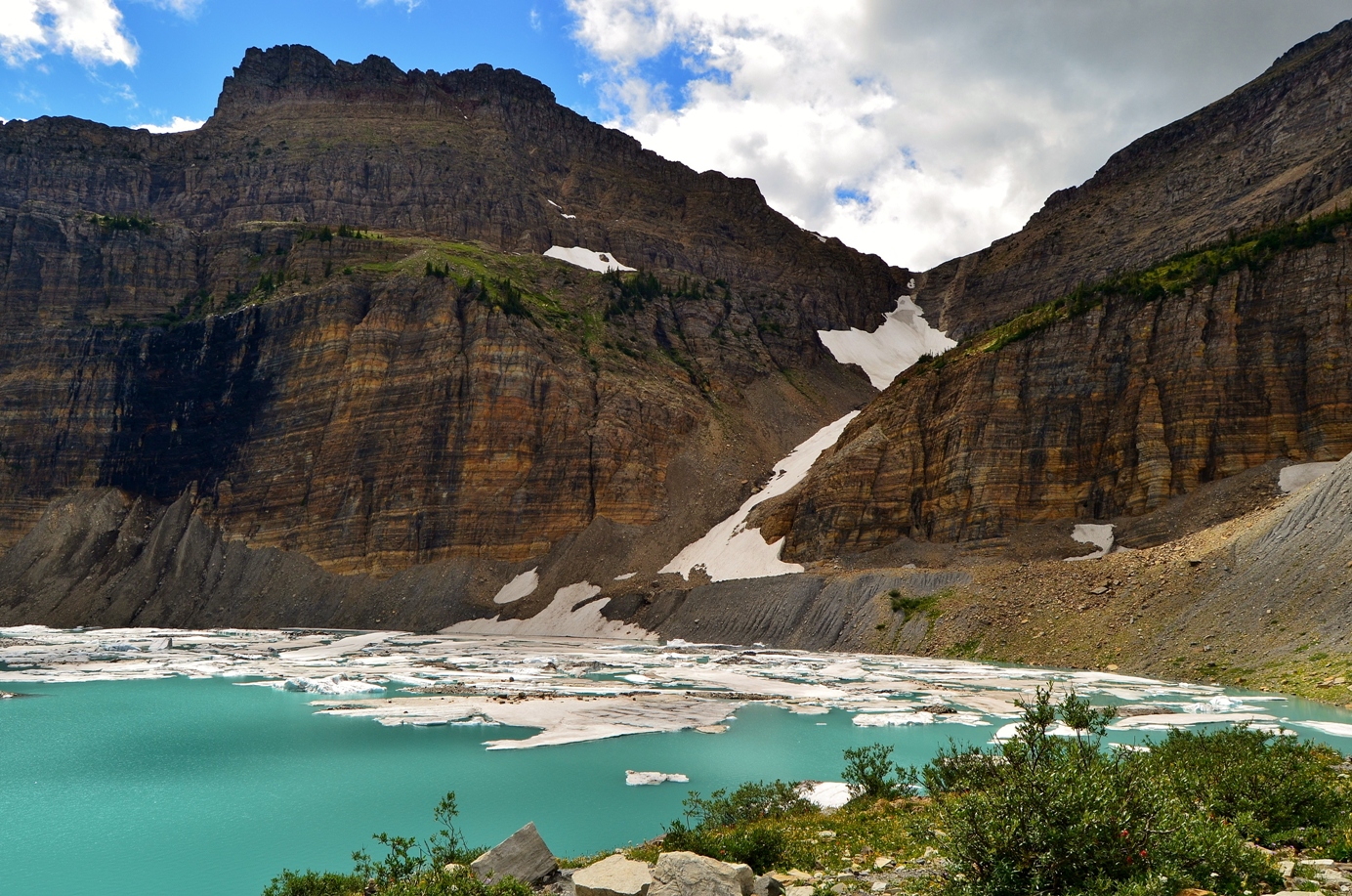
But once at the top, we could see Upper Grinnell Lake, certainly one of the most beautiful places in the world.


I headed down to the lake’s shore and indeed, the water was incredibly cold. There was no way I was getting in, even for a moment.


I contemplated it though – the icebergs were near the shore and if I could have handled the cold, I probably could have climbed onto an iceberg. But the water looked a lot deeper – after all, even the dumb high school kids didn’t get in. Across the lake, we could see Grinnell Glacier to the left and Salamander Glacier high up and in the middle. Salamander Falls flowed down from the glacier into the lake.


The water was such a beautiful color and there were many icebergs floating in the lake. I really enjoyed this hike – we hiked past four lakes, each more beautiful than the last. We spent some time here enjoying the magnificent glaciers that unfortunately, may not exist much longer.

Once finished, we started making our way back. The views were just as great hiking back.


It started to drizzle around the time we got back to Josephine Lake, but just lightly. It never really rained hard and we saw a beautiful rainbow across the lake.


The weather had cleared up by the time we got back to the parking lot and we headed to the Many Glacier area for dinner. The pizzeria next to the motel turned out to be pretty good. Our dining experiences were much better at restaurants in the park than those outside. The pizza was good and I tried a Huckleberry beer, which was very tasty. So much so that Sandy, who rarely drinks beer, had one too. After dinner, we made the long drive home from Many Glacier one more time. On the way out, we stopped again at a traffic jam.


There was another bear on the hill just above the road. This one was a mama bear with her cub. They scavenged around for food for a bit then disappeared into the woods. Once outside the park, we stopped to see the Reynolds Creek Fire.


After this point, it was starting to get dark, so we finished the drive back to Hungry Horse and went to bed immediately.

Monday, July 27, 2015

Going to the Sun Road

We slept in a bit in the morning and headed out in the late morning for a shorter drive. We headed into the park from the West Glacier side and drove Going-to-the-Sun Road to Avalanche Creek Trailhead. As we’d gotten a late start, the parking lot was full and we had to drive another mile up the road to park at Red Rock Point.


I headed down to McDonald Creek and got some pictures here - the water was a most beautiful turquoise color.


Then we walked the road to the trailhead and started off on Trail of the Cedars through a forest with some immense cedar and hemlock trees.


This forest reminded me of the Pacific Northwest. Then we got on Avalanche Creek Trail and started heading up the trail.


Shortly, there were some small waterfalls along the creek, flowing through some cool rock formations.


There were several large rocks wedged into the gorge. We stopped for pictures, then continued up the trail. This trail is relatively short and easy and so it was very popular, even in a light rain. In about 2 miles, we reached Avalanche Lake, which has at least three very tall waterfalls flowing down from Sperry Glacier into the lake.


I don’t think there’s any way to get closer, but they were quite impressive even from across the lake. Monument Falls is the only that is named on the topo map - I believe that it is the one furthest to the left. We ate lunch here sheltered under some trees from the rain, which started to pick up. So after lunch and some pictures, we headed back. Next, we continued up Going to the Sun Road, going as far as we could with the road closure due to the Reynolds Creek Fire. Past the loop, we stopped at several overlooks with views of the McDonald Creek Valley and Bird Woman Falls.


At nearly 500 feet, Bird Woman Falls is one of the highest in the park, but it can only be viewed from the overlooks, about 2 miles away.


Although I couldn’t get a close-up shot of the falls, the views were great, especially with the wildflowers blooming along the road. Heaven’s Peak was also visible, partially hidden by clouds.


We drove as far as Big Bend, where the road was currently closed and made a stop for pictures.


Then we started driving back.


We made one stop at the Loop for more views of Heaven’s Peak, then continued on towards Lake McDonald. At the head of McDonald Lake, we turned right onto a road that crosses the creek right where it feeds into the lake. Looking upstream, we could see the waterfall. We parked a little past here, then hiked McDonald Creek Trail to the waterfall.


The trail comes out near the top of the falls, but I was able to find a way to climb down some steep rocks to the base of the falls.


The falls were quite powerful and had a beautiful turquoise color, mixed in with the crashing whitewater. There were a lot of really pretty stones in the creek here as well.


I climbed back up and then we headed back to the car. We stopped at Apgar Village to buy souvenirs and I got some pictures of McDonald Lake.


We decided to just eat here at Eddie’s CafĂ©. This was the best food and service we’d had yet on the trip. Sandy had a glass of Huckleberry Riesling with dinner. We liked it so much, that we got two bottles from the gift shop after dinner. After dinner, we headed back to the house and got to bed early.

Sunday, July 26, 2015

Ptarmigan Tunnel and Iceberg Lake

Sunday morning, we woke up very early to leave the house at around 630. So early, in fact, that a deer was grazing in the backyard as we were getting ready to leave. She was surprised to see people up at this time! It was a long drive over to the Many Glacier area of the park. The Going to the Sun Road was closed due to the Reynolds Creek Fire, so we drove US-2 around the park and then headed north on MT-49 and US-89. We stopped at an overlook on US-89 near the Cut Bank entrance to the park for a couple pictures and the chance to stretch our legs. We stopped at another one further up where some horses and cows were grazing in the overlook. We arrived at Many Glacier around 930 and started our hike on the Ptarmigan/Iceberg Lake Trail. The trail starts along an open area with fantastic views of the glacier-carved mountains all around. The mountains were mostly clear of trees and so wildflowers along the slopes were exploding in color.


We had great views of Grinnell Point and Mount Wilbur.


The sky was cloudy and many of the mountain peaks were hidden by clouds.


In about 2.5 miles, we passed Ptarmigan Falls, though there was no good view of the waterfall from the trail due to dense vegetation. There didn’t appear to be any easy way to get a good view, so I would have to get creative to get a nice photo. I decided to try this on the way back. We stopped near the top of the falls for a snack break.


While we were eating, several Columbian ground squirrels came out.


Clearly, they were used to seeing people and looking for any scraps of human food to eat. After lunch, we crossed the creek and came to a split in the trail, where we turned right to head upstream along Ptarmigan Creek. The trail was a little steep, steadily heading upstream along the creek. It had started to rain, but it was just a light drizzle. All along the trail, the wildflowers were exploding in a rainbow of colors, so we hardly noticed the rain or steep incline.


Fireweed, asters, and Indian paintbrush were in full bloom along much of the trail.


In about 2 miles, we reached Ptarmigan Lake, the first of many gorgeous mountain lakes we would see this week.


From here, the trail steeply climbed up to Ptarmigan Tunnel via a couple of switchbacks.


It was a little cold and quite windy heading up, so I hiked quickly to the tunnel and had lunch inside, shielded from the wind behind the door. After lunch, I headed to the other side of the tunnel and right away, we saw some bighorn sheep.


Initially, they were right on the trail, but when they spotted people, they climbed up the cliff face. It was a small herd of females and juveniles, so their horns weren’t as impressive as a male’s. We walked a short ways past the tunnel, with nice views of Elizabeth Lake far below and Old Sun Glacier high on the mountains above.


A waterfall flowed out from in under the glacier. As we were heading back to the tunnel, a large hoary marmot came out and posed for some pictures.


He seemed to be just fine around people, but then got spooked and started climbing up the cliff face. I was amazed watching him climb – he rock-climbed just like a human.


Looking back and forth, he sought out hand holds and foot holds to boost himself up the rocks, then shimmied into a crack and climbed further up. We also saw a great big snow bank near the tunnel entrance. After such a hot summer in NC, it was nice to see snow in July! Just before we headed back into the tunnel, a golden-mantled ground squirrel popped out.


This area was a really great spot to view wildlife! We then headed back through the tunnel and down the switchbacks to Ptarmigan Lake. On the way down, we saw the herd of bighorn sheep, who had climbed over the tunnel and were now high up on Ptarmigan Wall. Heading down towards Ptarmigan Lake, it was noticeably warmer down here than up by the tunnel. From here, we backtracked towards Ptarmigan Falls and turned right to get on Iceberg Lake Trail.


The hike was along an open ridge with great views of the surrounding mountains and the wildflowers were in full bloom.


There was even a waterfall on the creek flowing out of Iceberg Lake, but it was too far away for a good picture.


As we approached Iceberg Lake, we hiked through a gorgeous wildflower meadow before the final leg of the hike, where we could see the lake.


From up here, we could see the icebergs on far side of the lake. We hiked down to the lake, but unfortunately, all the icebergs were on the other side and we didn't have as good of views.


When the icebergs are more plentiful, it’s possible to stand on them, but not today. I did take off my shoes and wade into the chilly waters, but it was too cold to go more than ankle deep.


After we were here for a while, a large group of high school students from Michigan arrived. They were actually brave (or stupid) enough to go all the way in, but that looked way too cold for me. Once in the water, they didn’t stay under long. After enjoying the beautiful lake for a while, we started making our way back.


When we got back to Ptarmigan Falls, I scrambled down the path for a better view of the waterfall. It was very steep, but I managed to get in a position for a decent shot of the waterfall.


Then I climbed back up and we continued hiking back to the parking lot. About half-way back to the parking lot from here, we spotted a moose grazing far below.


He was too far to get a good picture, but we were excited for our first moose sighting. Then we finished up the hike to the parking lot. We decided to get dinner on the way back and stopped at Serrano’s Mexican in East Glacier. It came highly recommended, though I can’t figure out why. On the way out of the park, a bunch of cars were pulled over, so we stopped too. A black bear was rummaging around just up from the road along the base of Altyn Peak.


Once out of the park, we called ahead to Serrano's as it was a big party, but still had to wait at least 30 minutes for a table. Once we finally got a table, we had to wait over an hour for our food. The waitress was not apologetic at all, I guess knowing she would get the automatic gratuity. The entire restaurant had cleared out and they were closing before they finally bothered to bring our food, which was mediocre at best. We were just glad to get out of there at that point. It was another hour or so to get back to the house in Hungry Horse and we were exhausted by the time we got back.