
Contact Information:
PO Box 515
Overton, NV 89040
Phone: (702) 397-2088
Email: vof@mvdsl.com
Directions:
Valley of Fire is located about 50 miles northeast of Las Vegas. From Las Vegas, go north on I-15 for about 30 miles and take exit 75 for Valley of Fire. Follow Valley of Fire Road for about 15 miles to the park. From Overton, take NV-169 south for about 9 miles and turn right on Valley of Fire Road. The park entrance will be in about 2 miles.
Map:
Trails:
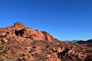
There are about a dozen hiking trails throughout the park, ranging in length from a tenth of a mile to almost seven miles. I've only visited once and had the chance to hike just a handful of the trails, but all of them had fantastic desert scenery.
Balancing Rock Trail:
Length: 0.1 miles (one way)
Difficulty: Easy
Balancing Rock Trail is a short trail that starts from the visitor center and leads out to view the Balancing Rock from different angles.

Elephant Rock Loop Trail:
Length: 1.2 miles (loop)
Difficulty: Moderate
Elephant Rock Trail is a 1.2 mile loop that starts from the parking lot at the east entrance of the park. The trail begins behind the picnic shelter and shortly reaches a split. It's a loop so you can either way, but left leads shortly to Elephant Rock. The trail approaches the road at Elephant Rock and runs parallel for a quarter-mile or so. Be sure to stay on the trail and off the road. In a quarter-mile or so, the trail departs from the road and meets up with Old Arrowhead Road Trail and the two run concurrently for the rest of the way back to trailhead.
Fire Wave Trail:
Length: 0.6 miles (one way)
Difficulty: Moderate
Fire Wave Trail begins from Turnout #3 on White Domes Road near the end of the road. The trail starts across the road from the parking and gradually heads down towards the base of Gibraltar Rock. The trail turns right and leads around to the south end of the mountain and then leads south to Fire Wave.

White Domes Loop Trail:
Length: 1.0 mile (loop)
Difficulty: Moderate
White Domes Trail begins from the picnic and parking area at the end of White Domes Road. The trail leads down along the east side of White Domes to a spot where the remains of an old film set are present. The trail then cuts through the Narrows a small slot canyon on Kaolin Wash. Through the narrow, the trail heads north along the west side of White Domes with stunning views of the surrounding landscape. At the north end of White Domes, the trail turn right and leads to the road just before the parking area.

Points of Interest:
Balancing Rock:
Balancing Rock, as the name suggests, is a rock that appears to be balancing precariously atop a rock outcrop. It's visible from White Domes Road and you can get a closer look from the short Balancing Rock Trail, accessed from the visitor center.

Dragon Rock:
I haven't seen any reference to Dragon Rock anywhere, but we spotted it right near the trailhead for Elephant Rock Trail. The rock really resembles a dragon's head and with the sunlight illuminating the mouth, it appears to be breathing fire!

Elephant Rock:
Elephant Rock is an amazing rock arch that has an uncanny resemblance to an elephant. You can see it from the road just west of the east entrance to the park, or hike the Elephant Rock Loop Trail for better views.

Film Set Remains:
Valley of Fire is a very popular for filming and producers are required to Leave No Trace. That wasn't always the case, and the remains from the 1965 movie The Professionals can be seen along the White Domes Trail. From the parking area, the remains are less than a half-mile south from the trailhead.

Fire Wave:
Fire Wave is a beautiful section of Aztec sandstone with candy-striped red and white rock. The area is accessed from the Fire Wave Trail at Turnout #3 on White Domes Road.

The Narrows:
The Narrows is a small slot canyon on Kaolin Wash. Except right after a storm, the canyon is dry. The Narrows is located about half way through the White Domes Loop Trail.

Wildlife:
Several species of cacti are found in the park. Beavertail cactus (Opuntia basilaris) is a species of prickly pear; it's not hard to figure how it got its name.

Blog Entries:
28-Oct-2017: Valley of Fire
External Links:
Nevada State Parks website: http://parks.nv.gov/parks/valley-of-fire
No comments:
Post a Comment