
Hike Length: 0.6 miles
Estimated Time: < 1 hour
Difficulty: Moderate
Location: Qualla Boundary
Trail Users: Hiking only
Dogs: Yes, but the trail is not dog friendly
Features: Waterfalls (1)
Crowds: Low
Warnings: The rocks around the waterfalls are very slippery. Use extreme caution passing by the top of Mingo Falls.
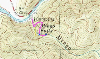
Trailhead GPS: 35.53406,-83.27618
Waterfall GPS: 35.53179,-83.27403
Directions:
From Cherokee, head north on US-441 from the junction with US-19 2.2 miles. Turn right on BIA-441 and then left on Big Cove Road in less than a quarter mile. Follow Big Cove Road for 4.8 miles and turn right on Mingo Falls Bridge Road, The parking area is across the bridge.
Map:
Hike Description:
Start hiking the Mingo Falls Trail and climb up the stairs. At the top of the stairs, go left on an overgrown path leading away from the main trail. In about 0.1 miles, the path switchbacks back towards the waterfall. There will be a path that comes in from the left; go straight until you get to a rocky area with a fence. Use caution here as you're close to the top of Mingo Falls. Scramble over the rocks and follow the path that leads upstream along Mingo Creek a short distance to the waterfall. There is a lower section first.

The trail then ends at the main section of the falls.

No comments:
Post a Comment