
Length: 1.9 miles (double loop)
Estimated Time: 1 hour
Difficulty: Easy
Location: William B. Umstead State Park
Trail Users: Hikers only
Dogs: Only if on a ≤ 6 foot leash
Features: Lakes, Creeks, Forest, Historical Ruins
Crowds: High
Warnings: None
Trailhead GPS: 35.87225,-78.76108
Directions:
The trailhead is at the last parking area at the Crabtree Creek entrance to Umstead State Park. The Crabtree Creek entrance is located about ten miles northwest of Raleigh on US-70. From I-40, take I-540 east (exit 283) for about 4 miles to to US-70 E (exit 4). The park entrance will be on the right after just over a mile. Follow the park road past the visitor center and stay straight at the left-hand turn. Park at the first parking area past the turn.
Map:
In the following map, the hike is shown in green and follows the loops in the counterclockwise direction.

Click here for an interactive map of the park.

Click here for an interactive map of the park.
Hike Description:
The hike begins at the north end of the parking lot at the trailhead for both Oak Rock and Potts Branch Trails. Start on the white-blazed Oak Rock Trail, which is the park's Track Trail. The trail splits almost immediately; go left to hike the loop counterclockwise. Tree identification signs along the trail educate hikers about the various trees found in the forest. As the trail approaches the road, it crosses Sal's Branch twice passing over an old dam.

The trail also passes by an old culvert from the time of the park's construction.

Just past here, the Oak Rock, the trail's namesake is just off the trail.

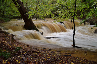
The trail loops back to the start in just over a half mile. Turn left on the orange-blazed Pott's Branch Trail. The trail will pass a picnic area and then descend to Sal's Branch towards the confluence with Pott's Branch. A scenic old dam is along the tributary here.

I visited once right after a heavy storm and the little creek was a raging torrent.
At Pott's Branch, the trail turns right to follow the creek downstream. After intersecting Sycamore Trail, the trail continues following Pott's Branch to the confluence with Sycamore Creek. An old dam is just upstream of the confluence.

Following Sycamore Creek upstream towards the dam, the trail then loops back through the picnic area back to the start.
External Links:
NC State Parks website: https://www.ncparks.gov/state-parks/william-b-umstead-state-park
No comments:
Post a Comment