Length: 12.2 miles (out and back) or 6.1 (shuttle)
Estimated Time: 4 to 5 hours
Difficulty: Moderate
Location: William B. Umstead State Park, Capital Area Greenway, Carl Alwin Schenck Memorial Forest
Trail Users: Hikers only
Dogs: No Dogs
Features: Creeks, Forest, Lakes
Crowds: Moderate
Warnings: The entrance to the Wade Avenue Tunnel is eroded and requires scaling the concrete wall with a rope for assistance. The tunnel itself is dark, rather long and usually filled with water.
Trailhead GPS: 35.83546,-78.75983 (Umstead State Park)
Shuttle GPS: 35.80089,-78.72545 (Richland Creek Greenway)
Directions:
The trailhead is at the Reedy Creek entrance to Umstead State Park. The Reedy Creek entrance is off Harrison Avenue, just north of exit 287 from I-40. The entrance is located about 11 miles west of Raleigh on I-40. From I-40, take the Harrison Ave. exit (287) and go north into the park.
To arrange a shuttle, leave the park on Harrison Avenue and turn left onto I-40 east. Go 1 mile and take exit 289 for Wade Avenue. In 1.4 miles, take the Edwards Mill exit and go right. Turn left on E. Stephen Stroud Way and the greenway parking will be on the left.
To arrange a shuttle, leave the park on Harrison Avenue and turn left onto I-40 east. Go 1 mile and take exit 289 for Wade Avenue. In 1.4 miles, take the Edwards Mill exit and go right. Turn left on E. Stephen Stroud Way and the greenway parking will be on the left.
Map:
Hike Description:
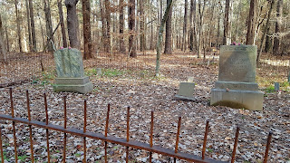
Loblolly Trail starts from the northeast corner of the Reedy Creek parking area and leads past a picnic area and the Young Cemetery.
The trail crosses a road and a powerline clearing then gradually heads down towards Reedy Creek. Large rocks were placed in the creek to provide a way across.
The trail ascends from the creek and crosses a couple intermittent streams, crossing Reedy Creek Multi-Use Trail in about 2 miles. The trail then passes Davies Pond and crosses South Turkey Creek Multi-Use Trail and leaves the park at 3.1 miles. It is now Richland Creek Trail, part of Raleigh's Capital Area Greenway. The trail emerges from the forest near the base of Richland Creek Lake.
The trail skirts the lake and comes out on Reedy Creek Road. Turn right along the sidewalk a short ways, then cross the street in a crosswalk to enter Carl Alwin Schenck Memorial Forest. No dogs and no bikes are allowed in the forest. The trail follows Richland Creek upstream through the forest along a wide floodplain that can be very muddy during wet times.
At about 5.5 miles from the start, the trail goes under Wade Avenue through a long tunnel. The entrance eroded so you have to scale across the concrete wall using the rope for assistance. This part of the trail may be difficult for some people.
The tunnel is quite long and is usually wet. The trail pops back up on the other side and leads to another short tunnel under Edwards Mill Road. After the second tunnel turn right to follow the sewer easement to the end at the greenway parking in front of PNC Arena. If you shuttled, the car will be here. Otherwise, hike back the way you came.
External Links:
NC State Parks website: https://www.ncparks.gov/state-parks/william-b-umstead-state-park
North Carolina State University Forests website for Schenck Forest: https://sites.google.com/a/ncsu.edu/ncsudof-forests/home/carlalwinschenckmemorialforest
Raleigh Parks, Recreation and Cultural Resources website for Capital Area Greenway: https://raleighnc.gov/home/content/PRecDesignDevelop/Articles/CapitalAreaGreenwayTrailSystem.html


No comments:
Post a Comment