Hike Length: 0.6 miles
Estimated Time: < 1 hour
Difficulty: Easy
Location: Brewery Park at Tumwater Falls
Trail Users: Hiking only
Dogs: Must be on a ≤ 6-foot leash.
Features: Waterfalls (3)
Crowds: High
Warnings: None
Trailhead GPS: 47.01350,-122.90446
Waterfall GPS: 47.01817,-122.90410
Directions:
From Olympia, head south on I-5 to exit 103 for 2nd Avenue. Continue for 0.1 miles and turn left on Custer Way. Across the river, turn right on Boston Street and cross the river again. Turn left on Deschutes Way and go 0.2 miles. Turn right on C Street and then left into the parking area.
Map:
Hike Description:
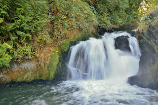
The paved trail along the river starts behind the restrooms and follows the river downstream, passing Upper Tumwater Falls right away and Middle Tumwater Falls when it passes under Custer Way. The trail ends at 0.3 miles where a footbridge crosses over the waterfall.Steps lead down to an overlook on the river. The river splits into two streams at the waterfall. Only the river-right stream is visible from here. I think you could view the river-left stream from the footbridge, but it was closed when we visited.
Blog Entries:
24-Sep-2022: Spoon Creek Falls
External Links:
Olympia Tumwater Foundation website: https://olytumfoundation.org/what-we-do/tumwater-falls-park/


No comments:
Post a Comment