Hike Length: 0.8 miles
Estimated Time: < 1 hour
Difficulty: Easy
Location: Wilkes County
Trail Users: Hiking only
Dogs: Only if on a ≤ 6 foot leash
Features: Waterfalls (1+)
Crowds: Moderate
Warnings: The rocks around the waterfalls are very slippery. The final descent to the base is steep.
Trailhead GPS: 36.28914,-80.88016
Waterfall GPS: 36.28830,-80.88447
Directions:
To visit the falls, head north from Elkin on US-21 Business for about 2 miles and turn left on E Carter Mill Road. Drive 1.6 miles and turn right on Pleasant Ridge Road. A gravel parking area at the trailhead is on the left in 0.6 miles.
Map:
Hike Description:
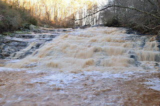
Pick up the Carter Falls Trail from the north end of the parking area, which is blazed with white circles for the Mountains-to-Sea Trail. The trail descends towards the creek then makes a wide switchback to the top of the waterfall.
The trail then reaches an intersection with Powerhouse Trail, which continues to Lower Carter Falls. Turn right and descend steeply to the base of the waterfall.
You can scramble around on the rocks to view from different angles.
The sun shines right on the waterfall so try to visit on a cloudy day or early in the morning for the best pictures.
Here's a video of the falls.
Blog Entries:
04-Mar-2023: Elkin Waterfalls
11-May-2020: Wildflowers and Waterfalls along Basin Creek
03-Aug-2019: Flowers and Falls at Doughton Park


No comments:
Post a Comment