
Contact Information:
South Rim Visitor Center
9800 Highway 347
Montrose, CO 81401
Phone: (970) 641-2337 x205
Directions:
I've only visited the north rim of the park. The south rim is easily accessed from US-50 east of Montrose. To visit the north rim, head west from Montrose on US-50 for about 17 miles to Delta. Turn right on CO-92 east and go 31 miles to Crawford. Turn right on Fruitland Mesa Road and go 4.5 miles and turn right on Black Canyon Road. In 0.8 miles, turn left to stay on Black Canyon Road. Continue for 6.9 miles, entering the park. Bear right and the North Rim Ranger Station is on the right in under a half-mile.
Map:
Hiking:
Chasm View Trail:
Chasm View Nature Trail is a short half-mile interpretive trail that starts from the South Rim Campground. Interpretive booklets are available at the trailhead. The trail passes through sagebrush and a small pygmy forest of Utah juniper and pinyon pine and then to the edge of the rim. Painted Wall is visible in the distance. The trail follows the rim a short ways with great views of the Black Canyon, then loops back around to the start.

North Vista Trail:
North Vista Trail is a 3-mile trail that leads from the North Rim Ranger Station to Green Mountain. In 1.5 miles, a short spur leads to Exclamation Point. I've only hiked the trail this far.

Inner Canyon Routes:
There are several inner canyon routes that lead from the rim down to the river. All are extremely steep and difficult. Wilderness permits are required for all inner canyon adventures and can be obtained from the ranger station or visitor center. Even in low water, it is never possible to cross the river as it is deep and fast moving.
Long Draw:
The park service calls this route the Long Draw, but it was formerly called Devil's Slide and I like that better. Parking is at the Balanced Rock View, just a mile or so southeast of the North Rim Ranger Station. From the parking, hike up the road to the curve and head down into the draw. A sign for Long Gulch is here, indicating a permit is required to continue. Devil's Slide is extremely steep, dropping 1800 vertical feet in a half-mile with a slope of more than 40%. The first part descends through a grove of box elder trees that provide something to hold on to. After that, its just loose rocks and gravel. There are two tricky sections near the middle where you'll have to climb down a small ledge and you can begin to see the river from about the halfway point.

When you reach the Gunnison River, there's only about a quarter-mile to walk up and down along the river. Downstream, sheer cliffs prevent going downstream. Upstream is the Narrows, the narrowest part of the canyon - only 40 feet with sheer cliffs on either side.

Points of Interest:
Balanced Rock View:
Balanced Rock View is an overlook about 1.2 miles southeast of the North Ranger Station. A short path leads to the overlook. A huge boulder that appears to be balancing precariously is right next to the overlook. This is the parking to hike the Long Draw Inner Canyon route and you can see how steep it is going down to the river from the overlook.

The Narrows View:
The Narrows View is about a mile southeast of the North Rim Ranger Station just before Balanced Rock View. The overlook provides views of the Narrows, the narrowest section of the canyon at only 40 feet wide at the river.

Wildlife:
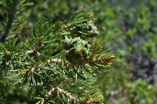
Black Canyon of the Gunnison is in the Colorado Plateau, a region of high deserts and steep canyons. Pinyon pine (Pinus edulis) is a small pine common to the pygmy forests of the canyon rim.
Another tree that grows alongside the pinyon pine is the Utah juniper (Juniperus osteosperma).

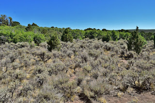
Sagebrush is a drought-tolerant bush throughout the high desert.
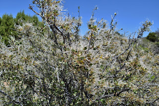
Curl-leaf mountain mahogany (Cercocarpus ledifolius) is a shrub that produces feathery flowers.
Scarlet gilia (Ipomopsis aggregata) is a wildflower in the phlox family.

Plateau lizards (Sceloporus tristichus) are the most common lizard in the park.

Golden-mantled ground squirrels (Callospermophilus lateralis) are common in the park.

Blog Entries:
01-Jul-2018: Black Canyon of the Gunnison
External Links:
National Park Service website: https://www.nps.gov/blca/index.htm
No comments:
Post a Comment