Sunday, June 18, 2017

Ponies & Waterfalls

Sunday, we woke up early and broke camp and then headed up to Massie Gap for a hike before leaving Grayson Highlands State Park.  Right at the trailhead, beautiful flame azalea were blooming fiery orange flowers.


Hiking the Rhododendron Trail, we started heading up, passing more beautiful azaleas and wildflowers, including ragwort.


The mountain laurel were starting to bloom here and we had a nice view of Twin Pinnacles in the distance.


The mountain laurel were not quite at peak, but the pink buds were very colorful.


A little further there was some flame azaleas with really deep orange flowers.


In a short ways, where the Rhododendron Trail and North Horse Trail met up, we saw our first wild ponies of the day - two adults and a little boy.


The mother pony used a trail sign as a scratching post and the little boy came over to emulate his mother.


Continuing on the trail we came to a larger group of ponies grazing just before the trail leaves the park.


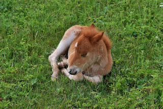
There were several adults and three little babies, alternating between nursing and grazing for food.


We spent some time here getting pictures as the babies were really cute.


One was taking a little nap without a care in the world.


Sandy and I alternated between holding Alex and viewing the ponies.  He was very excited about the ponies, but not sure what he'd do with them, so we kept him a safe distance a way.  Continuing on, we entered Mount Rogers National Recreation Area and took the Rhododendron Gap Trail towards its namesake.  Another smaller herd of ponies were right along the trail and it was tricky maneuvering Alex around them as he really wanted to play.


There were some babies here too.


We definitely picked a good time to visit and see the baby ponies.


Continuing on, the trail crosses the AT and then finally intersects with the Crest Trail near Rhododendron Gap. We went right on Crest Trail for a quarter-mile to Rhododendron Gap.  Unfortunately, the rhododendron were all past peak - recent storms had knocked off any remaining flowers, though I did find one flower.


We climbed up the rock outcrop here for a snack and to enjoy the views of Mount Rogers and the surrounding mountains.


Even without the rhododendron flowers, it's still a beautiful spot.


After our break, we took the AT back Grayson Highlands.  Back in the park, we stopped again at the larger herd of ponies.  One of the babies came up and starting rubbing himself on my pants.


I try not to get too close or approach the ponies, but this one approached me and I didn't want to make any sudden movements.  I scratched his itchy spot until he seemed satisfied and then continued on.  At the intersection, we went right on Rhododendron Trail to head back towards Massie Gap.


Getting close to the cars, we weren't quite ready to leave, so we hiked the Cabin Creek Trail, going left at the split to hike the loop in the clockwise direction.  The trail descends steeply along a tributary to Cabin Creek and then follows the creek upstream.  We stopped at Lower Waterfall on Cabin Creek for a couple of pictures.


It was kind of warm so I took off my boots and waded in the shallow pool with Alex.  Above enjoying the main drop, I rock-hopped to the small island for a view of the upper drop of the waterfall.


Continuing on, where the trail cuts back to the right to finish up the loop, we continued upstream to the Upper Waterfall on Cabin Creek.  It's a long series of steep cascades but there's no good viewing spot.


I bushwhacked up a ways and then made a difficult climb down to see the upper most drops, but there was a lot of downfall so hard to get a decent picture.  Then we finished up the loop back at Massie Gap.


On the way home, we stopped at Foothills Brewpub in Winston-Salem for dinner and drinks before finishing the drive home.

Saturday, June 17, 2017

The Channels of Virginia

Saturday, we woke up and left the park, heading northwest.  We stopped for breakfast and gas in Chilhowie and continued past Saltville to Channels State Forest and the Brumley Mountain Trailhead off VA-80.  The parking area was nearly full as this is a popular hike.  After getting our stuff together, we started hiking down the trail, which is a private road at this point.  In about a mile, the trail leaves private property and heads into The Channels State Natural Area Preserve and became steeper.  There were a number of wildflowers blooming along the trail that made for a welcome break.


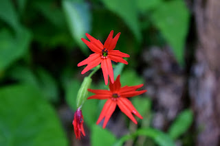
The lilies were just beautiful - not sure if they're native or invasive species.  There was also some bright red fire pink blooming along the trail.


It was about another 2 miles, mostly uphill, to a split where a short spur trail leads to the Channels.  There were some flame azalea blooming up here.


Just before the lookout tower, we went left on a short path that came out at the "Hidden Channels", a smaller version of the Channels.


The views from up top were great and it was cool peering down into the narrow crevasses, so we had lunch up here - much less crowded than the main Channels.


After lunch I went around the other side, but couldn't find a way to get in the Hidden Channels.


So we headed back towards the lookout tower.


Before heading into the Channels, we climbed up to get views above.


Peering down into the crevasses below, I could hear people walking around down there.


We then headed down into the Channels.  Being almost like a cave, it was noticeably cooler in here, a nice relief from the heat and humidity.


We wandered around up and down the narrow passageways.  Set up like a grid, it would be difficult to get lost in here.


Alex found a spot where he tried furiously to dig a hole in the sand - not sure what got into him, but he really wanted to dig and didn't care who was standing behind him.  At the far end of the Channels, I found a huge rock that looked like a bone!


After thoroughly exploring the Channels up and down, we started heading back, passing the mountain laurel near the summit.


At Brumley Mountain Trail, we turned left to continue down the mountain a short ways and then turned left on the Channels Trail that led steeply down.  The first mile or so was extremely overgrown with stinging nettle and not a particularly nice hike, though a few wildflowers were blooming along the trail.


We were going to take a left turn on a Forest Trail to start heading back, but couldn't find it.  The Channels Trail picked up North-South Road and became a little easier to follow thought it was still steep.  We spotted a huge wolf spider along the road at one spot.


After passing an area where they appeared to be doing some construction work, we turned left on Clinch Mountain Road immediately before a gate and followed this road back towards the start. Along this road we saw a cute baby box turtle.


At the third creek crossing, which was Eddington Branch, we followed a Forest Path back up to Brumley Mountain Trail near the private property boundary.  Our detour to make the hike a loop was longer than expected so we hiked quickly back to the car.  Along the way, we saw a large black snake right long the road.


At least it was all downhill from here and soon we made it back.


Back at the car, we started making our way back to Grayson Highlands, stopping to eat at Buck's Drive-In in Saltville.  We had Alex so this seemed like a good spot and the food was really good and inexpensive.  We even got Alex his own hot dog for doing so well on the trail and he really enjoyed it.  Heading back to the park, we stopped at Sugarlands Overlook for nice evening views and then headed back to camp.


After taking a shower, we built a nice campfire and had some drinks before retiring for the evening.

Friday, June 16, 2017

Wilson Creek Hike

With the sweltering heat in Raleigh, we decided to head north for the weekend and try to stay cool in the highlands of Virginia.  We left Friday after work and headed to Grayson Highlands State Park.  It rained a bit on the way up, but was dry by the time we arrived.  After setting up our tent, we took Alex for a hike while we waited for Justine and Kristen to show up.  We started hiking down Seed Orchard Road along a wide old road.  In under a mile, we went right at a fork to get on Wilson Creek Trail and head down to the creek.  Where the trail met up with the creek, we continued upstream a short ways to a small waterfall.


The water level was too high to get across, but I think there would be a better view from the other side.  Then we got back on the main trail and followed the creek downstream.  In a short ways, we came to the main Waterfall on Wilson Creek.


There are several nice drops along the creek, but the state park mentions a 25-foot waterfall on the creek and I'm pretty sure that this is the one they're referring to.  In high water, it was really impressive.  A little further down was a nice cascading section.


And a little past that was another scenic drop.


 I think all of these would have looked better from the other side, but it was getting late and crossing would have been tough in the high water.  We finished up the loop with a steep climb back up to the road and headed back to camp.  There were some flame azaleas blooming around the campground.


When we got back to our campsite, no one else had yet arrived.


Justine and Kristen ended up getting stuck in traffic and didn't arrive until well after dark.  We were all really tired by this point and went to bed early.